
File:United States House of Representatives, California District 12.png
此为最大尺寸。
United_States_House_of_Representatives,_California_District_12.png (181 × 233像素,文件大小:20 KB,MIME类型:image/png)
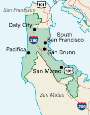
| 描述 | California Congressional District 12, clipped from U.S. National Atlas (printable congressional districts map section) en:Category:Congressional district maps of the 109th Congress | |||
| 来源 | National Atlas of the United States | |||
| 作者 | United States Department of the Interior | |||
| 授权 (二次使用本文件) |
|
原始上传日志
原始描述頁面位於這裡。下列使用者名稱均來自en.wikipedia。
- 2006-10-25 04:10 Cheeselord 181×233×8 (20419 bytes) California Congressional District 12, clipped from [http://nationalatlas.gov/printable/congress.html U.S. National Atlas (printable congressional districts map section)] {{PD-USGov-Atlas}} [[Category:Congressional district maps of the 108th Congress]] [[Category:Congressional district maps of California]] [[
文件历史
点击某个日期/时间查看对应时刻的文件。
| 日期/时间 | 缩略图 | 大小 | 用户 | 备注 | |
|---|---|---|---|---|---|
| 当前 | 2006年12月4日 (一) 17:22 | | 181 × 233(20 KB) | Shyam | {{Information |Description=California Congressional District 12, clipped from [http://nationalatlas.gov/printable/congress.html U.S. National Atlas (printable congressional districts map section)] [[:en:Category:Congressional district maps of the 109th Co |
文件用途
没有页面链接到本图像。
全域文件用途
以下其他wiki使用此文件:
- pt.wikipedia.org上的用途