File:Vesta-Elevation.jpg
Vesta-Elevation.jpg (500 × 500像素,文件大小:43 KB,MIME类型:image/jpeg)
文件历史
点击某个日期/时间查看对应时刻的文件。
| 日期/时间 | 缩略图 | 大小 | 用户 | 备注 | |
|---|---|---|---|---|---|
| 当前 | 2006年1月30日 (一) 07:57 |  | 500 × 500(43 KB) | Arnomane | higher resolution |
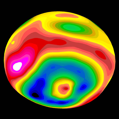
| 2005年8月24日 (三) 17:56 |  | 200 × 200(6 KB) | Vesta~commonswiki | * Description: A color-encoded elevation map of Vesta clearly shows the giant 460-kilometer diameter impact basin and "bull's-eye" central peak. The map was constructed from 78 Wide Field Planetary Camera 2 pictures. Surface topography was estimated by no |
文件用途
以下页面使用本文件:
全域文件用途
以下其他wiki使用此文件:
- als.wikipedia.org上的用途
- ar.wikipedia.org上的用途
- ca.wikipedia.org上的用途
- cs.wikipedia.org上的用途
- de.wikipedia.org上的用途
- en.wikipedia.org上的用途
- es.wikipedia.org上的用途
- eu.wikipedia.org上的用途
- fa.wikipedia.org上的用途
- fi.wikipedia.org上的用途
- fr.wikipedia.org上的用途
- ko.wikipedia.org上的用途
- lb.wikipedia.org上的用途
- mk.wikipedia.org上的用途
- oc.wikipedia.org上的用途
- pt.wikipedia.org上的用途
- ro.wikipedia.org上的用途
- simple.wikipedia.org上的用途
- sk.wikipedia.org上的用途
- sv.wikipedia.org上的用途
- uk.wikipedia.org上的用途
- www.wikidata.org上的用途


