
File:Vuiamor2.jpg
此为最大尺寸。
Vuiamor2.jpg (640 × 428像素,文件大小:136 KB,MIME类型:image/jpeg)
摘要
| 描述 |
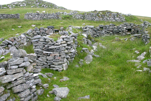
English: Ruined croft houses on w:Fuaigh Mòr. The remains of houses and sheep fanks on the deserted island. The island was cleared of its inhabitants in 1841, and is now only used for grazing sheep. w:Loch Roag.
Español: Casas de cría en ruinas en Fuaigh Mòr (isla del Reino Unido situada en Escocia). Esta zona de Fuaigh Mòr quedó deshabitada en 1841, y en la actualidad solamente es usada para pastorear ovejas.
|
||
| 日期 | |||
| 来源 |
|
||
| 作者 | Sarah Egan |

| 相机位置 | | 在以下服务上查看本图像和附近其他图像: OpenStreetMap |
|---|
| 物体位置 | | 在以下服务上查看本图像和附近其他图像: OpenStreetMap |
|---|
_region:GB-GBN_heading:270.00&language=zh)
许可协议
本文件采用知识共享署名-相同方式共享 2.0 通用许可协议授权。
- 您可以自由地:
- 共享 – 复制、发行并传播本作品
- 修改 – 改编作品
- 惟须遵守下列条件:
- 署名 – 您必须对作品进行署名,提供授权条款的链接,并说明是否对原始内容进行了更改。您可以用任何合理的方式来署名,但不得以任何方式表明许可人认可您或您的使用。
- 相同方式共享 – 如果您再混合、转换或者基于本作品进行创作,您必须以与原先许可协议相同或相兼容的许可协议分发您贡献的作品。
文件历史
点击某个日期/时间查看对应时刻的文件。
| 日期/时间 | 缩略图 | 大小 | 用户 | 备注 | |
|---|---|---|---|---|---|
| 当前 | 2008年7月7日 (一) 13:12 | | 640 × 428(136 KB) | MacRusgail | == Summary == {{Information| |Description=Ruined croft houses on w:Fuaigh Mòr. The remains of houses and sheep fanks on the deserted island. The island was cleared of its inhabitants in 1841 and is now only used for grazing sheep. w:Loch Roag. |S |
文件用途
全域文件用途
以下其他wiki使用此文件:
- az.wikipedia.org上的用途
- cs.wikipedia.org上的用途
- cy.wikipedia.org上的用途
- da.wikipedia.org上的用途
- de.wikipedia.org上的用途
- en.wikipedia.org上的用途
- es.wikipedia.org上的用途
- eu.wikipedia.org上的用途
- fi.wikipedia.org上的用途
- ga.wikipedia.org上的用途
- gd.wikipedia.org上的用途
- gl.wikipedia.org上的用途
- he.wikipedia.org上的用途
- hr.wikipedia.org上的用途
- it.wikipedia.org上的用途
- ja.wikipedia.org上的用途
- nn.wikipedia.org上的用途
- ru.wikipedia.org上的用途
- sco.wikipedia.org上的用途
- sh.wikipedia.org上的用途
- sv.wikipedia.org上的用途
- uk.wikipedia.org上的用途
- www.wikidata.org上的用途