
File:Yasi feb 1 2011 0000Z.jpg

本预览的尺寸:459 × 599像素。 其他分辨率:184 × 240像素 | 368 × 480像素 | 588 × 768像素 | 784 × 1,024像素 | 1,569 × 2,048像素 | 7,200 × 9,400像素。
原始文件 (7,200 × 9,400像素,文件大小:7.93 MB,MIME类型:image/jpeg)
| 警告 | 部分浏览器在浏览此图片的完整大小时可能会遇到困难:该图片中有数量巨大的像素点,可能无法完全载入或者导致您的浏览器停止响应。 |
|---|
摘要
| 描述 |
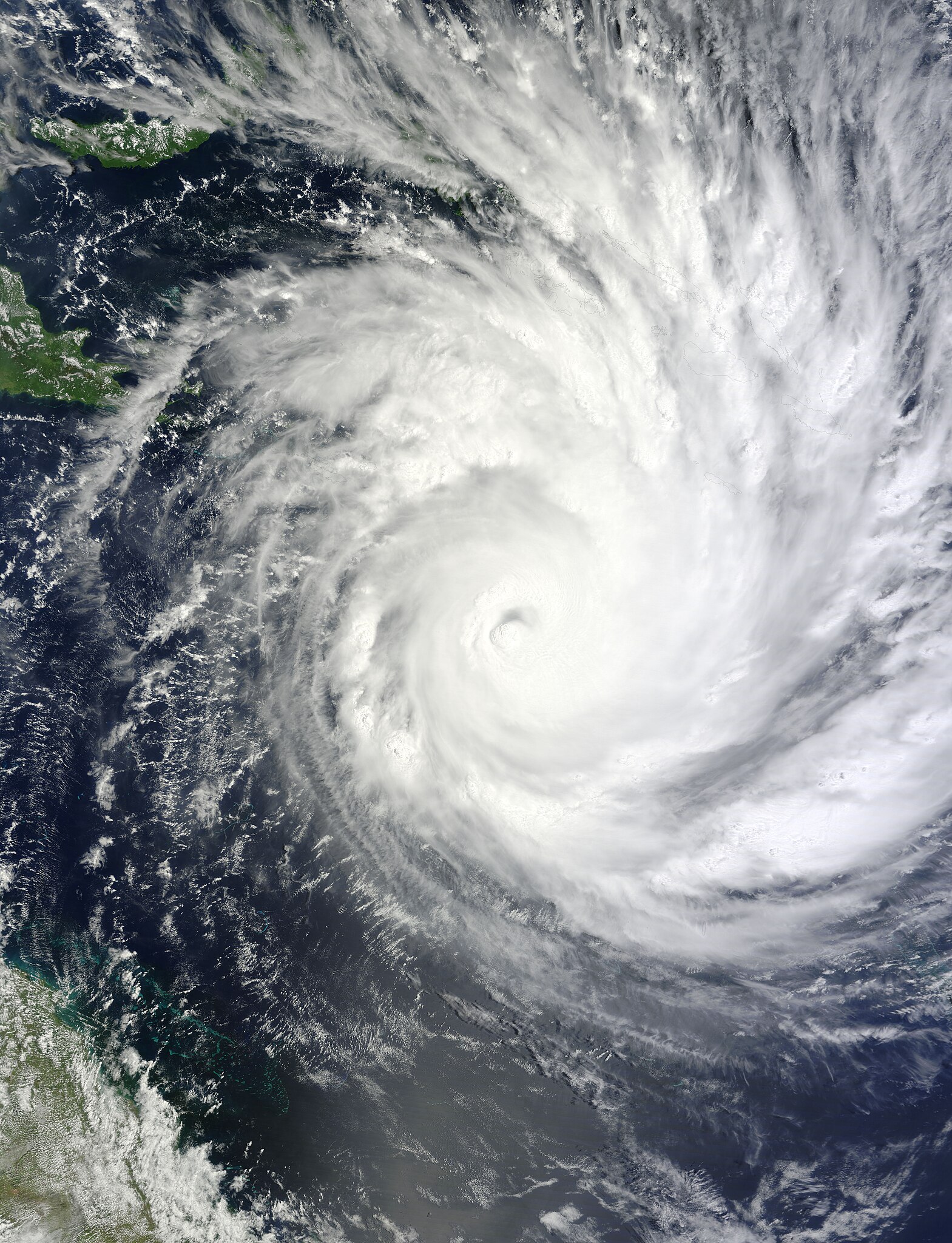
English: On February 1, 2011, Tropical Cyclone Yasi continued on its path toward Queensland, Australia. The Moderate Resolution Imaging Spectroradiometer (MODIS) on NASA’s Terra satellite captured this natural-color image at 10:00 a.m. Queensland time (00:00 UTC) on February 1. The storm extends over the Solomon Islands (outlined in black) and grazes Papua New Guinea. Part of the Queensland coast appears in the lower left corner of the image.
At 1:00 a.m. on February 2 Queensland time (15:00 on February 1 UTC), the U.S. Navy’s Joint Typhoon Warning Center (JTWC) reported that Yasi was roughly 450 nautical miles (835 kilometers) east-northeast of Cairns, Queensland, Australia. Sporting a well-defined eye, Yasi had maximum sustained winds of 120 knots (220 kilometers per hour) and gusts up to 145 knots (270 kilometers per hour). True to earlier forecasts, favorable conditions had enabled the storm to intensify rapidly over the Pacific Ocean. The JTWC forecast that Yasi would continue to strengthen and would remain on west-southwestward track. The storm was expected to make landfall just south of Cairns, bringing high winds and potentially high waves. The Sydney Morning Herald reported that tens of thousands of residents were evacuating ahead of the storm’s anticipated landfall late February 2 or early February 3. |
| 日期 | |
| 来源 | http://rapidfire.sci.gsfc.nasa.gov/gallery/?2011032-0201/Yasi.A2011032.0000.2km.jpg |
| 作者 | NASA image by Jeff Schmaltz, MODIS Rapid Response Team at NASA GSFC. Caption by Michon Scott |
许可协议
| 本文件完全由NASA创作,在美国属于公有领域。根据NASA的版权方针,NASA的材料除非另有声明否则不受版权保护。(参见Template:PD-USGov/zh、NASA版权方针页面或JPL图片使用方针。) | ||
 |
警告:
|
文件历史
点击某个日期/时间查看对应时刻的文件。
| 日期/时间 | 缩略图 | 大小 | 用户 | 备注 | |
|---|---|---|---|---|---|
| 当前 | 2023年8月13日 (日) 13:52 | | 7,200 × 9,400(7.93 MB) | Nino Marakot | Original color |
| 2011年2月1日 (二) 11:07 |  | 7,200 × 9,400(10.9 MB) | Supportstorm | {{Information |Description ={{en|1=Severe Tropical Cyclone Yasi, as a category three, on February 1, 2011.}} |Source =http://rapidfire.sci.gsfc.nasa.gov/gallery/?2011032-0201/Yasi.A2011032.0000.2km.jpg |Author =NASA/ GSFC, MODIS Rapid R |
文件用途
以下页面使用本文件:
全域文件用途
以下其他wiki使用此文件:
- en.wikipedia.org上的用途
- pt.wikipedia.org上的用途