
File:Bay-of-Piran maritime-boundary-dispute.jpg
無更高解析度可提供。
Bay-of-Piran_maritime-boundary-dispute.jpg (709 × 600 像素,檔案大小:160 KB,MIME 類型:image/jpeg)
摘要

|
File:Bay-of-Piran maritime-boundary-dispute.svg是本檔案的向量版本。 如果品質不低,就應該優先使用該檔案,而非JPG檔案。
File:Bay-of-Piran maritime-boundary-dispute.jpg → File:Bay-of-Piran maritime-boundary-dispute.svg
更多資訊請參閱Help:SVG/zh。 |
 |
| 描述 |
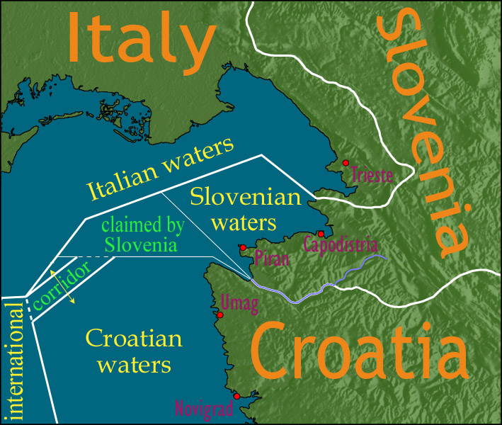
English: Map showing a diplomatic dispute resulting from Slovenia's desire to obtain a direct corridor from its own territorial waters to international waters, to avoid the necessity of Slovenian ships having to sail through the territorial waters of any other country to get to the high seas. Slovenia's only seacoast is in the Bay of Piran / Gulf of Trieste (as shown in this map), and its only commercial seaport is Capodistria / Koper (the eastern of the two red dots in Slovenia on this map), while Italy and Croatia both have long seacoasts outside the area shown in this map.
Slovenia's claim to the area labelled with green text, and the existence of a corridor to international waters, would have been allowed by Croatia under the Drnovšek-Račan agreement, but this was never ratified by either countries' parliaments. This is an English version of image de:Bild:Grenzstreit-Bucht-von-Piran.jpg, created using image Image:BorderDispute_BayOfPiran_blank.png. Raw Adobe Photoshop PSD files (with all text on different type layers) are available on request. |
| 日期 | |
| 來源 | File:BorderDispute_BayOfPiran_blank.png |
| 作者 |
|
| 授權許可 (重用此檔案) |
The underlying source Image:BorderDispute_BayOfPiran_blank.png is declared to be GFDL, while I declare my changes to it to be PD. |
| 其他版本 | 此檔案衍生的作品: Bay-of-Piran maritime-boundary-dispute.svg |

授權條款

|
已授權您依據自由軟體基金會發行的無固定段落、封面文字和封底文字GNU自由文件授權條款1.2版或任意後續版本,對本檔進行複製、傳播和/或修改。該協議的副本列在GNU自由文件授權條款中。 |
| 此檔案採用創用CC 姓名標示-相同方式分享 3.0 未在地化版本授權條款。 | ||
| ||
| 已新增授權條款標題至此檔案,作為GFDL授權更新的一部份。 |
檔案歷史
點選日期/時間以檢視該時間的檔案版本。
| 日期/時間 | 縮圖 | 尺寸 | 使用者 | 備註 | |
|---|---|---|---|---|---|
| 目前 | 2007年1月8日 (一) 14:17 | | 709 × 600(160 KB) | AnonMoos | adding city names |
| 2006年12月24日 (日) 18:13 |  | 709 × 600(156 KB) | AnonMoos | deepening colors slightly | |
| 2006年12月14日 (四) 14:00 |  | 709 × 600(156 KB) | AnonMoos | Map showing diplomatic dispute over Slovenia's desire to obtain a direct corridor from its own territorial waters to international waters, to avoid Slovenian ships having to sail through the territorial waters of any other country to get to the high seas. |
檔案用途
下列頁面有用到此檔案:
全域檔案使用狀況
以下其他 wiki 使用了這個檔案:
- de.wikipedia.org 的使用狀況
- en.wikipedia.org 的使用狀況
- en.wikinews.org 的使用狀況
- es.wikipedia.org 的使用狀況
- fy.wikipedia.org 的使用狀況
- it.wikipedia.org 的使用狀況
- ja.wikipedia.org 的使用狀況
- ko.wikipedia.org 的使用狀況
- pl.wikipedia.org 的使用狀況
- sl.wikipedia.org 的使用狀況