
File:Essonne department location map.svg

此 SVG 檔案的 PNG 預覽的大小:578 × 600 像素。 其他解析度:231 × 240 像素 | 463 × 480 像素 | 740 × 768 像素 | 987 × 1,024 像素 | 1,974 × 2,048 像素 | 982 × 1,019 像素。
原始檔案 (SVG 檔案,表面大小:982 × 1,019 像素,檔案大小:125 KB)
摘要
| 拍攝地點 | | 位於此地的本圖片與其他圖片: OpenStreetMap |
|---|
| 描述 |
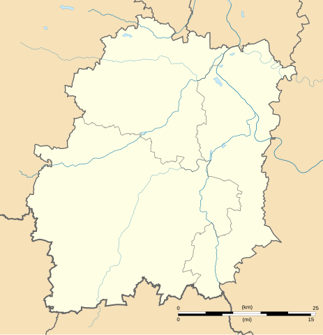
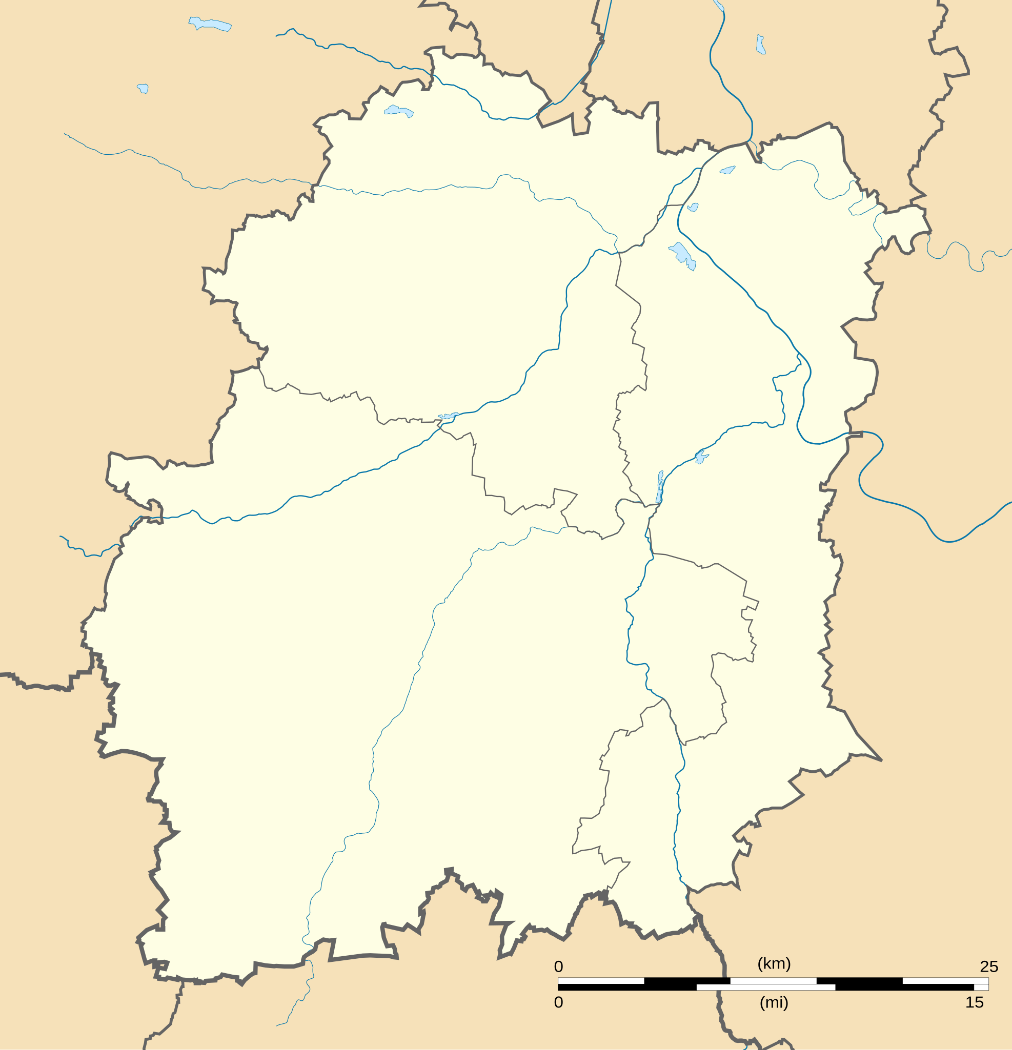
English: Blank administrative map of the department of Essonne, France, for geo-location purpose, with distinct boundaries for regions, departments and arrondissements.
Français : Carte administrative vierge du département de l'Essonne, France, destinée à la géolocalisation, avec limite distincte des régions, départements et arrondissements. Equirectangular projection, WGS84 datum
Geographic limits of the map:
|
||
| 日期 | |||
| 來源 |
自己的作品
|
||
| 作者 | Eric Gaba (Sting - fr:Sting) | ||
| 授權許可 (重用此檔案) |
|
||
| 其他版本 |
此檔案衍生的作品: Essonne Communes frontières.png
|

授權條款
我,本作品的著作權持有者,決定用以下授權條款發佈本作品:
此檔案採用創用CC 姓名標示-相同方式分享 3.0 未在地化版本授權條款。
- 您可以自由:
- 分享 – 複製、發佈和傳播本作品
- 重新修改 – 創作演繹作品
- 惟需遵照下列條件:
- 姓名標示 – 您必須指名出正確的製作者,和提供授權條款的連結,以及表示是否有對內容上做出變更。您可以用任何合理的方式來行動,但不得以任何方式表明授權條款是對您許可或是由您所使用。
- 相同方式分享 – 如果您利用本素材進行再混合、轉換或創作,您必須基於如同原先的相同或兼容的條款,來分布您的貢獻成品。

|
已授權您依據自由軟體基金會發行的無固定段落、封面文字和封底文字GNU自由文件授權條款1.2版或任意後續版本,對本檔進行複製、傳播和/或修改。該協議的副本列在GNU自由文件授權條款中。 |
您可以選擇您需要的授權條款。
檔案歷史
點選日期/時間以檢視該時間的檔案版本。
| 日期/時間 | 縮圖 | 尺寸 | 使用者 | 備註 | |
|---|---|---|---|---|---|
| 目前 | 2008年9月3日 (三) 17:54 | | 982 × 1,019(125 KB) | Bourrichon | Reverted to version as of 20:11, 13 August 2008 Révocation des pastilles qui empêchent une pleine utilisation de la carte |
| 2008年9月2日 (二) 22:35 |  | 982 × 1,019(126 KB) | Bourrichon | Déplacement des pastilles ajoutées pour qu'elles n'apparaissent pas en double (Préfectures : Évry, Palaiseau, Étampes) | |
| 2008年9月2日 (二) 22:32 |  | 982 × 1,019(126 KB) | Bourrichon | ||
| 2008年9月2日 (二) 22:08 |  | 982 × 1,019(126 KB) | Bourrichon | ||
| 2008年8月13日 (三) 20:11 |  | 982 × 1,019(125 KB) | Sting | + Yvette river | |
| 2008年8月13日 (三) 15:13 |  | 982 × 1,019(120 KB) | Sting | == Summary == {{Location|48|31|30|N|02|15|00|E|scale:1000000}} <br/> {{Information |Description={{en|Blank administrative map of the department of Essonne, France, for geo-location purpose, with distinct boundaries for regions, departments |
檔案用途
超過 100 個頁面有用到此檔案。 下列清單只列出前 100 筆有用到此檔案的頁面。 您也可以檢視完整清單。
- 丰特奈勒维孔特
- 丰特奈莱布里
- 伊尼
- 伊特维尔
- 伊韦特河畔日夫
- 克罗讷
- 利斯 (埃松省)
- 利穆尔
- 利纳斯
- 勒库德赖-蒙索
- 勒德维尔
- 博尔讷 (埃松省)
- 吉布维尔
- 吉莱尔瓦勒
- 圣热讷维耶沃代布瓦
- 埃夫里
- 埃斯图什
- 埃松河畔吉涅维尔
- 埃松河畔巴朗库尔
- 埃松河畔布蒂尼
- 埃松河畔库尔迪芒什
- 埃松河畔日龙维尔
- 埃格利
- 埃沙尔孔
- 埃特雷希
- 埃皮奈苏塞纳尔
- 埃蒂奥勒
- 塞尔尼
- 奥尔日河畔勒维尔
- 奥尔日河畔埃皮奈
- 奥尔日河畔布雷蒂尼
- 奥尔日河畔瑞维西
- 奥尔日河畔隆蓬
- 奧賽
- 孔热维尔-蒂永维尔
- 尚克伊
- 尚普朗
- 尚莫特
- 巴兰维利耶
- 布勒-茹伊
- 布勒耶
- 布吕努瓦
- 布吕耶尔勒沙泰勒
- 布朗迪 (埃松省)
- 布泰尔维利耶
- 布瓦埃尔潘
- 布瓦涅维尔
- 布瓦西勒塞克
- 布瓦西勒屈泰
- 布瓦西拉里维耶尔
- 布瓦西苏圣永
- 布维尔 (埃松省)
- 布莱莱特鲁
- 布西圣安托万
- 布里耶尔莱塞莱
- 布里苏福尔日
- 布鲁伊
- 希伊-马萨林
- 库尔库罗讷
- 库尔松-蒙特卢
- 库朗斯
- 弗勒里梅罗日斯
- 德拉韋伊
- 戈梅斯勒沙泰勒
- 戈梅斯城
- 拉尔迪
- 拉福雷勒鲁瓦
- 拉福雷圣克鲁瓦
- 方丹拉里维耶尔
- 昂热维利耶
- 昂热维尔
- 杜尔当
- 格里尼
- 欧通拉普莱讷
- 欧韦尔圣乔治
- 欧韦尔诺
- 比耶夫尔 (埃松省)
- 比诺博讷沃
- 沙卢-穆利讷
- 沙洛圣马尔
- 沙蒂尼翁维尔
- 沙马朗德
- 瑞讷河畔布赖
- 瑞讷河畔让维尔
- 福尔日莱班
- 科尔布勒斯
- 科尔贝伊-埃松
- 绍富尔莱塞特雷希
- 莱格朗日勒鲁瓦
- 蒙莱里
- 让夫里
- 谢普坦维尔
- 达讷穆瓦
- 迈斯
- 迪松-隆格维尔
- 邦杜夫勒
- 阿夫兰维尔
- 阿尔帕容
- 阿莱堡
- 阿蒂斯蒙斯
檢視連結到這個檔案的更多連結。
全域檔案使用狀況
以下其他 wiki 使用了這個檔案:
- als.wikipedia.org 的使用狀況
- de.wikipedia.org 的使用狀況
- dsb.wikipedia.org 的使用狀況
- eo.wikipedia.org 的使用狀況
- Évry (Essonne)
- Ŝablono:Situo sur mapo
- Ŝablono:Situo sur mapo/dokumentado
- Grigny (Essonne)
- Ŝablono:Situo sur mapo/testoj
- Palaiseau
- Ŝablono:Situo sur mapo Francio Essonne
- Ŝablono:Situo sur mapo/multoble
- Ŝablono:Situo sur mapo/multoble/dokumentado
- Courcouronnes
- Chamarande
- Crosne (Essonne)
- Ballancourt-sur-Essonne
- Montlhéry
- Évry-Courcouronnes
- Ballainvilliers
- Morangis (Essonne)
- Saulx-les-Chartreux
- Cerny
- Fleury-Mérogis
- eu.wikipedia.org 的使用狀況
- fr.wikipedia.org 的使用狀況
- Essonne (département)
- Chapelle Saint-Blaise-des-Simples de Milly-la-Forêt
- École polytechnique universitaire de l'université Paris-Saclay
- Centre national du rugby
- La Ville-du-Bois
- Château du Saussay
- Institut d'optique Graduate School
- Château du Marais
- Courcouronnes
- Arboretum municipal de Verrières-le-Buisson
- Château des Roches (Bièvres)
- Musée français de la photographie
- Château de Courances
- Estouches
- Wissous
- Abbaye Notre-Dame d'Yerres
檢視此檔案的更多全域使用狀況。