
File:Growth of Habsburg territories.jpg

預覽大小:800 × 475 像素。 其他解析度:320 × 190 像素 | 640 × 380 像素 | 1,024 × 608 像素 | 1,280 × 760 像素 | 2,275 × 1,350 像素。
原始檔案 (2,275 × 1,350 像素,檔案大小:1.02 MB,MIME 類型:image/jpeg)
摘要
| 描述 |
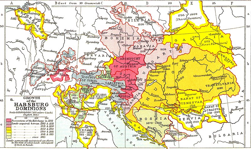
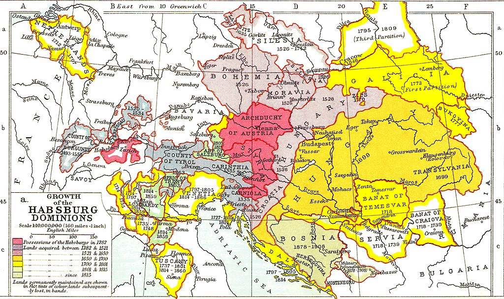
English: Growth of the Habsburg Dominions. Territorial changes of the Austrian Habsburg branch. |
| 日期 | |
| 來源 |
Ramsay Muir, 1911, Philips' New Historical Atlas for Students, plate 25a, 1st edition, Philip & Son. https://openlibrary.org/books/OL25906533M/Philips%27_new_historical_atlas_for_students |
| 作者 | Ramsay Muir |
授權條款
|
本作品在其來源國以及其他著作權期限是作者逝世後70年或以下的國家與地區屬於公有領域。 | |
| 此作品無已知的著作權限制,亦不受所有相關和鄰接的權利限制。 | |
檔案歷史
點選日期/時間以檢視該時間的檔案版本。
| 日期/時間 | 縮圖 | 尺寸 | 使用者 | 備註 | |
|---|---|---|---|---|---|
| 目前 | 2022年11月25日 (五) 19:37 | | 2,275 × 1,350(1.02 MB) | Gyalu22 | Reverted to version as of 08:54, 16 March 2016 (UTC) |
| 2017年12月23日 (六) 19:24 |  | 2,275 × 1,350(1.03 MB) | MAXHO | Reverted to version as of 2015 according with cited sources | |
| 2016年3月16日 (三) 08:54 |  | 2,275 × 1,350(1.02 MB) | Fakirbakir | back to the original version | |
| 2015年11月30日 (一) 17:12 |  | 2,275 × 1,350(1.03 MB) | Spiridon Ion Cepleanu | Some details according with « Grosser Atlas zur Weltgeschichte » (H.E.Stier, dir.) Westermann 1985, ISBN 3-14-100919-8, « Putzger historischer Weltatlas Cornelsen » 1990, ISBN 3-464-00176-8 & « Történelmi atlasz a középiskolák számára », K... | |
| 2014年5月13日 (二) 21:31 |  | 2,275 × 1,350(1.02 MB) | CSvBibra | contrast | |
| 2009年2月15日 (日) 20:27 |  | 2,275 × 1,350(956 KB) | Bizso | {{Information |Description={{en|1=Growth of Habsburg territories.}} |Source=[http://www.heritage-history.com/maps/philips/phil025a.jpg] |Author=unknown |Date=unnowkn |Permission= |other_versions= }} <!--{{ImageUpload|full}}--> |
檔案用途
下列3個頁面有用到此檔案:
全域檔案使用狀況
以下其他 wiki 使用了這個檔案:
- als.wikipedia.org 的使用狀況
- ar.wikipedia.org 的使用狀況
- azb.wikipedia.org 的使用狀況
- ba.wikipedia.org 的使用狀況
- be-tarask.wikipedia.org 的使用狀況
- be.wikipedia.org 的使用狀況
- bg.wikipedia.org 的使用狀況
- bn.wikipedia.org 的使用狀況
- br.wikipedia.org 的使用狀況
- ca.wikipedia.org 的使用狀況
- cs.wikipedia.org 的使用狀況
- da.wikipedia.org 的使用狀況
- el.wikipedia.org 的使用狀況
- en.wikipedia.org 的使用狀況
- es.wikipedia.org 的使用狀況
- et.wikipedia.org 的使用狀況
- fa.wikipedia.org 的使用狀況
- fi.wikipedia.org 的使用狀況
- frr.wikipedia.org 的使用狀況
- fr.wikipedia.org 的使用狀況
檢視此檔案的更多全域使用狀況。