
File:China, 742.svg

此SVG文件的PNG预览的大小:705 × 599像素。 其他分辨率:282 × 240像素 | 565 × 480像素 | 904 × 768像素 | 1,205 × 1,024像素 | 2,409 × 2,048像素 | 1,000 × 850像素。
原始文件 (SVG文件,尺寸为1,000 × 850像素,文件大小:168 KB)
摘要
| 描述 |
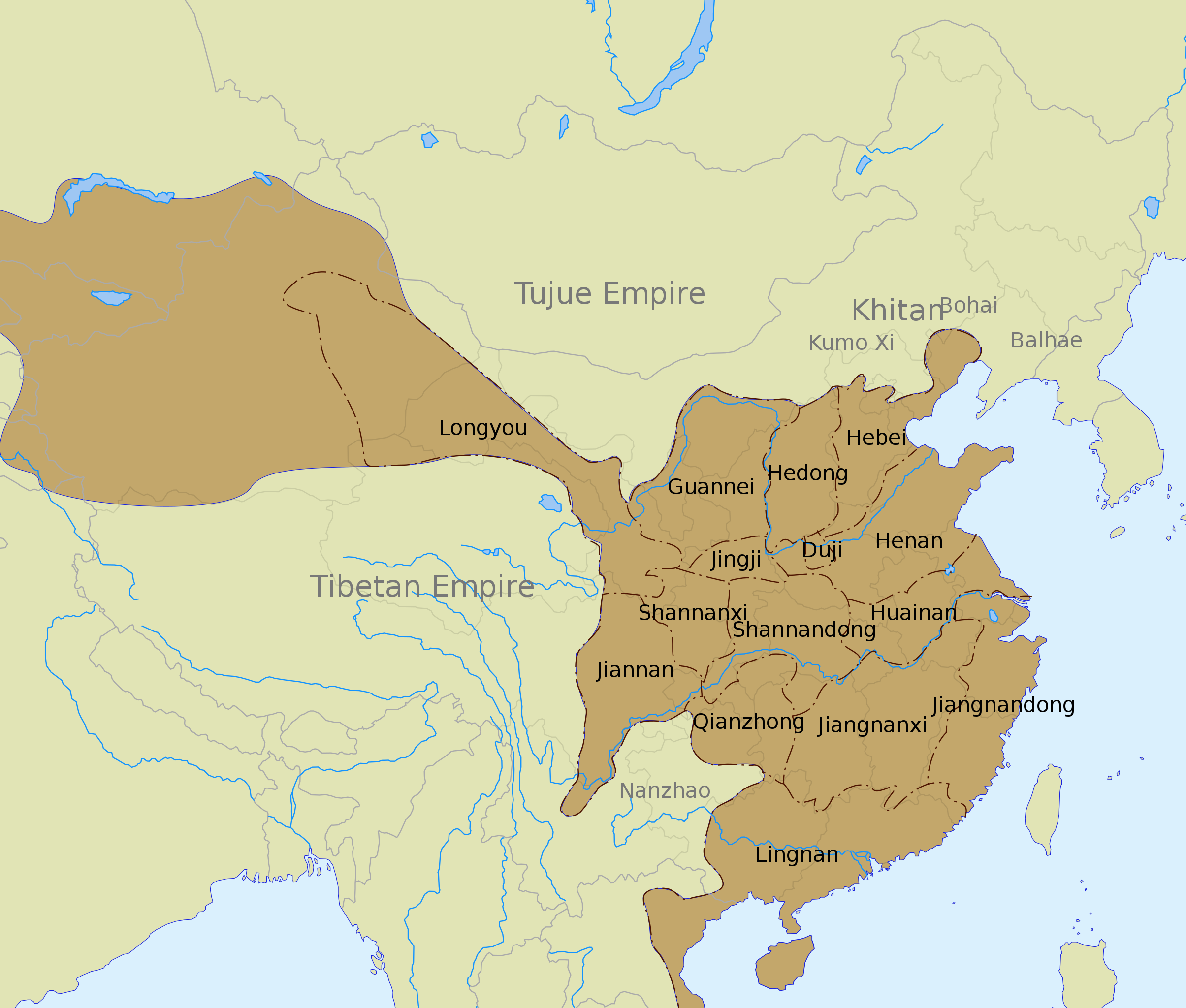
English: The Tang dynasty territory and inspection circuits (道 dào) in 742, according to the Cambridge History of China. |
| 日期 | |
| 来源 |
See also:
|
| 作者 | Yug |
| 其他版本 |
Derivative works of this file: |
| SVG开发 |
许可协议
我,本作品著作权人,特此采用以下许可协议发表本作品:
本文件采用知识共享署名-相同方式共享 3.0 未本地化版本许可协议授权。
- 您可以自由地:
- 共享 – 复制、发行并传播本作品
- 修改 – 改编作品
- 惟须遵守下列条件:
- 署名 – 您必须对作品进行署名,提供授权条款的链接,并说明是否对原始内容进行了更改。您可以用任何合理的方式来署名,但不得以任何方式表明许可人认可您或您的使用。
- 相同方式共享 – 如果您再混合、转换或者基于本作品进行创作,您必须以与原先许可协议相同或相兼容的许可协议分发您贡献的作品。
文件历史
点击某个日期/时间查看对应时刻的文件。
| 日期/时间 | 缩略图 | 大小 | 用户 | 备注 | |
|---|---|---|---|---|---|
| 当前 | 2020年3月12日 (四) 01:45 | | 1,000 × 850(168 KB) | Jonteemil | Fake SVG Reverted to version as of 17:36, 16 December 2012 (UTC) |
| 2019年1月14日 (一) 06:10 |  | 1,000 × 850(278 KB) | 复旦大学张超 | Bohai and Balhae are the same | |
| 2012年12月16日 (日) 17:36 |  | 1,000 × 850(168 KB) | Kanguole | Revise western extent of civil administration per Cambridge History | |
| 2008年5月30日 (五) 04:40 |  | 1,000 × 850(221 KB) | Yug | Correction for the eastern area, according to a newly find sources. | |
| 2008年5月29日 (四) 05:04 |  | 1,000 × 850(221 KB) | Yug | ||
| 2008年5月28日 (三) 18:56 |  | 1,000 × 850(218 KB) | Yug | {{Information |Description={{en|1=The Tang dynasty territory and provinces in 742, according to the Cambridge History of China.<br />NB: The Western area was not depict by my source, accordingly, this area (Longyou province, 隴右) is show by a blur area |
文件用途
没有页面使用本文件。
全域文件用途
以下其他wiki使用此文件:
- azb.wikipedia.org上的用途
- bo.wikipedia.org上的用途
- ca.wikipedia.org上的用途
- ce.wikipedia.org上的用途
- de.wikipedia.org上的用途
- en.wikipedia.org上的用途
- History of China
- Tang dynasty
- Han Chinese
- History of the Khitans
- Circuit (administrative division)
- An Lushan
- Emperor Xuanzong of Tang
- Wikipedia:Graphics Lab/Images to improve/Archive/Jul 2008
- User talk:PericlesofAthens/Archive 5
- Jiangnanxi Circuit
- Jiangnan Circuit
- Administrative divisions of the Tang dynasty
- User:Falcaorib
- Administration of territory in dynastic China
- Talk:Tang dynasty/Archive 4
- fa.wikipedia.org上的用途
- fr.wikipedia.org上的用途
- hak.wikipedia.org上的用途
- id.wikipedia.org上的用途
- lt.wikipedia.org上的用途
- nl.wikipedia.org上的用途
- no.wikipedia.org上的用途
- ru.wikipedia.org上的用途
- tr.wikipedia.org上的用途
- uk.wikipedia.org上的用途
- uz.wikipedia.org上的用途
- vi.wikipedia.org上的用途
- www.wikidata.org上的用途
查看本文件的更多全域用途。