
File:Saint Paul Island Alaska aerial view.jpg

本预览的尺寸:800 × 523像素。 其他分辨率:320 × 209像素 | 640 × 419像素 | 1,024 × 670像素 | 1,500 × 981像素。
原始文件 (1,500 × 981像素,文件大小:589 KB,MIME类型:image/jpeg)
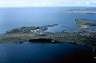
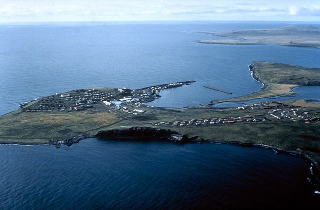
| 描述 | Aerial view of St. Paul Island | |||
| 图中地点 | St. Paul Island, Alaska, USA |
|||
| 日期 | not specified or unknown | |||
| 来源 |
U.S. Army Corps of Engineers Digital Visual Library Image page Image description page Digital Visual Library home page |
|||
| 作者 | U.S. Army Corps of Engineers, photographer not specified or unknown | |||
| 授权 (二次使用本文件) |
|
| 相机位置 | | 在以下服务上查看本图像和附近其他图像: OpenStreetMap |
|---|
| 物体位置 | | 在以下服务上查看本图像和附近其他图像: OpenStreetMap |
|---|
文件历史
点击某个日期/时间查看对应时刻的文件。
| 日期/时间 | 缩略图 | 大小 | 用户 | 备注 | |
|---|---|---|---|---|---|
| 当前 | 2007年3月20日 (二) 01:44 | | 1,500 × 981(589 KB) | DanMS | {{Information | Description = Aerial view of St. Paul Island | Source = U.S. Army Corps of Engineers Digital Visual Library<br />[http://images.usace.army.mil/images/Hires/4414-19.Jpg Image page]<br />[http://images.usace.army.mil/scripts/PortW |
文件用途
以下2个页面使用本文件:
全域文件用途
以下其他wiki使用此文件:
- az.wikipedia.org上的用途
- be.wikipedia.org上的用途
- br.wikipedia.org上的用途
- ceb.wikipedia.org上的用途
- de.wikipedia.org上的用途
- en.wikipedia.org上的用途
- es.wikipedia.org上的用途
- fi.wikipedia.org上的用途
- fr.wikipedia.org上的用途
- gl.wikipedia.org上的用途
- ja.wikipedia.org上的用途
- pt.wikipedia.org上的用途
- ru.wikipedia.org上的用途
- www.wikidata.org上的用途