
File:Ardf map.png
Ardf_map.png (600 × 550 像素,檔案大小:430 KB,MIME 類型:image/png)
source/author
摘要
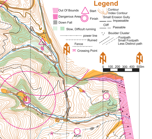
On this portion of an ARDF map, the start location is indicated by a triangle and the finish location is indicated by two concentric circles. The locations of two of the five transmitters are indicated on this version of the map with circles and the labels MOH and MO5 - on the versions of the map given to competitors, the locations of the transmitters are not indicated.
This map is a portion of the Cibola National Forest in the Sandia Mountains east of Albuquerque, New Mexico, USA. The map was used for the eighty meter competition of the Third IARU Region II ARDF Championship, August 5, 2005. This map is not created to International Orienteering Federation standards for orienteering maps.
The map was created in 2005 by Jerry Boyd of Albuquerque, New Mexico, with field checking by Gail Boyd, Taylor Boyd, Jack Stump, Scott Stevenson, and Jerry Boyd. Contact information for these individuals is available at the Albuquerque Transmitter Hunters archive copy at the Wayback Machine web site. This image of the map has been released under GFDL by its author, Jerry Boyd, and is used with permission.
A subsequent map of the same terrain has been created from scratch by professional mapmakers working on behalf of New Mexico Orienteers archive copy at the Wayback Machine. Work on that map began in 2005, after the completion of the 2005 IARU Region II ARDF Championship.
授權條款
| 此檔案採用創用CC 姓名標示-相同方式分享 3.0 未在地化版本授權條款。 受免責聲明的約束。 | ||
| ||
| 已新增授權條款標題至此檔案,作為GFDL授權更新的一部份。 |

|
已授權您依據自由軟體基金會發行的無固定段落、封面文字和封底文字GNU自由文件授權條款1.2版或任意後續版本,對本檔進行複製、傳播和/或修改。該協議的副本列在GNU自由文件授權條款中。 受免責聲明的約束。 |
檔案歷史
點選日期/時間以檢視該時間的檔案版本。
| 日期/時間 | 縮圖 | 尺寸 | 使用者 | 備註 | |
|---|---|---|---|---|---|
| 目前 | 2006年3月12日 (日) 20:46 | | 600 × 550(430 KB) | Greudin | == Summary == On this portion of an ARDF map, the start location is indicated by a triangle and the finish location is indicated by two concentric circles. The locations of two of the five transmitters are indicated on |
檔案用途
全域檔案使用狀況
以下其他 wiki 使用了這個檔案:
- cs.wikipedia.org 的使用狀況
- en.wikipedia.org 的使用狀況
- en.wikibooks.org 的使用狀況
- en.wikiversity.org 的使用狀況
- en.wikivoyage.org 的使用狀況
- fr.wikipedia.org 的使用狀況
- pl.wikipedia.org 的使用狀況
- sk.wikipedia.org 的使用狀況
- zh-yue.wikipedia.org 的使用狀況