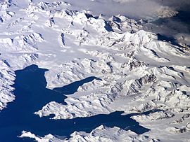
阿勒代斯山脈
| 阿勒代斯山脈 | |
|---|---|
Allardyce Range | |
 Central South Georgia: Cumberland Bay; Thatcher Peninsula with King Edward Cove (Grytviken); Allardyce Range with the summit Mount Paget (NASA imagery). | |
| 最高点 | |
| 海拔 | 2,935米(9,629英尺) [1] |
| 坐标 | 54°25′S 36°32′W / 54.417°S 36.533°W |
| 地理 | |
| 位置 | 南乔治亚岛 |
阿勒代斯山脈(英語:Allardyce Range)是南喬治亞島與南桑威奇群島的山脈,最高點海拔高度2,935米,山體由沉積岩組成,該山脈在1915年以福克蘭群島總督命名。
| 这是一篇南乔治亚和南桑威奇群岛的小作品。你可以通过编辑或修订扩充其内容。 |
