奇尔特恩丘陵
外观
| 奇尔特恩丘陵 Chiltern Hills | |
|---|---|
 | |
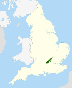
 在英格兰的位置 | |
| 最高点 | |
| 山峰 | 哈丁顿山 |
| 海拔 | 267米(876英尺) |
| 规模 | |
| 长度 | 74千米(46英里) |
| 宽度 | 18千米(11英里) |
| 面积 | 833平方千米(322平方英里) |
| 地理 | |
| 位置 | 东南英格兰 |
| 国家 | 英格兰 |
| 郡 | 贝德福德郡 白金汉郡 赫特福德郡 牛津郡 |
| 山脉坐标 | 51°40′N 0°55′W / 51.667°N 0.917°W |
奇尔特恩丘陵(Chiltern Hills)是位于英格兰东南边缘的土工丘陵地带,面积833平方千米(322平方英里),范围包括牛津郡、白金汉郡、贝德福德郡、赫特福德郡[1]。该地区曾是一个木材资源地,现大部分地区为杰出自然风景区。
参考资料
[编辑]- ^ The Changing Landscape of the Chilterns (页面存档备份,存于互联网档案馆) Chilterns AoNB, Accessed 19 February 2012
