
File:12E Hurricane Kristy 2006.jpg

預覽大小:571 × 600 像素。 其他解析度:228 × 240 像素 | 457 × 480 像素 | 731 × 768 像素 | 975 × 1,024 像素 | 1,949 × 2,048 像素 | 4,419 × 4,643 像素。
原始檔案 (4,419 × 4,643 像素,檔案大小:12.47 MB,MIME 類型:image/jpeg)
摘要
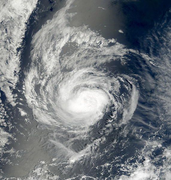
| 描述 | This image of Hurricane Kristy was captured by the MODIS instrument on NASA's Terra satellite at 1843 UTC on August 31, 2006 when it was located in the eastern Pacific Ocean. At the time, maximum sustained winds were 75 mph and the minimum pressure was approximately 987 mb. | ||||||
| 日期 | |||||||
| 來源 | http://www.nrlmry.navy.mil/tc_pages/tc_home.html | ||||||
| 作者 | Naval Research Laboratory | ||||||
| 授權許可 (重用此檔案) |
|
||||||

檔案歷史
點選日期/時間以檢視該時間的檔案版本。
| 日期/時間 | 縮圖 | 尺寸 | 使用者 | 備註 | |
|---|---|---|---|---|---|
| 目前 | 2013年3月5日 (二) 21:17 | | 4,419 × 4,643(12.47 MB) | Supportstorm | Color |
| 2006年9月5日 (二) 19:45 |  | 3,220 × 3,220(1.58 MB) | Good kitty | == Summary == {{Information |Description=This image of Hurricane Kristy was captured at 1843 UTC on August 31, 2006 when it was located in the eastern Pacific Ocean. At the time, maximum sustained winds were 75 mph and the minimum pressure was approximate |
檔案用途
下列6個頁面有用到此檔案:
全域檔案使用狀況
以下其他 wiki 使用了這個檔案:
- de.wikipedia.org 的使用狀況
- en.wikipedia.org 的使用狀況
- es.wikipedia.org 的使用狀況
- pt.wikipedia.org 的使用狀況
- simple.wikipedia.org 的使用狀況