
File:3D locations in Google Earth.svg

此 SVG 檔案的 PNG 預覽的大小:800 × 406 像素。 其他解析度:320 × 162 像素 | 640 × 325 像素 | 1,024 × 520 像素 | 1,280 × 650 像素 | 2,560 × 1,300 像素 | 2,754 × 1,398 像素。
原始檔案 (SVG 檔案,表面大小:2,754 × 1,398 像素,檔案大小:1.15 MB)
1st street ne Watson Saskatchewan
摘要
| 描述 |
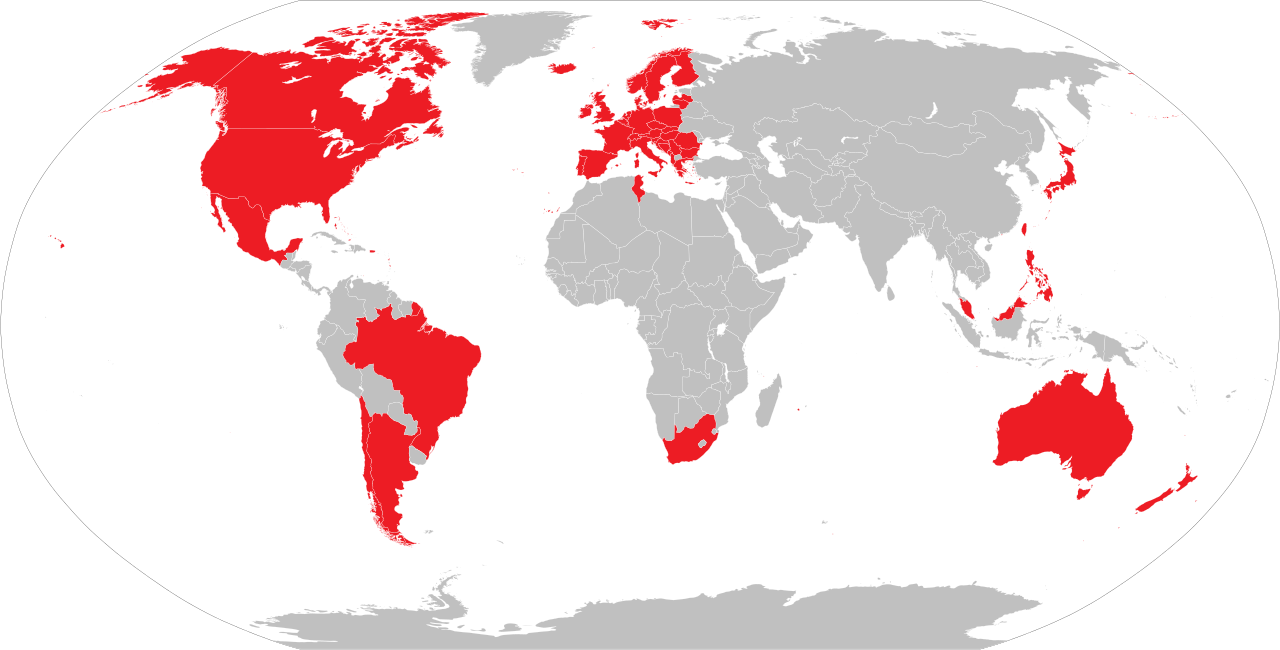
English: Countries and territories with 3D coverage in Google Earth as of November 2019.
Countries and territories with 3D coverage. Countries and territories with former 3D coverage. Countries and territories without 3D coverage. |
| 日期 | |
| 來源 | 自己的作品 |
| 作者 | Soumya-8974 |
| SVG開發 |

|
本圖像有可用的柵格版本。當其品質較佳時,就應該替代此矢量圖像。
File:3D locations in Google Earth.svg → File:3D locations in Google Earth.png
通常,最好使用好的矢量版本(SVG)。 |
授權條款
我,本作品的著作權持有者,決定用以下授權條款發佈本作品:
此檔案採用創用CC 姓名標示 4.0 國際授權條款。
- 您可以自由:
- 分享 – 複製、發佈和傳播本作品
- 重新修改 – 創作演繹作品
- 惟需遵照下列條件:
- 姓名標示 – 您必須指名出正確的製作者,和提供授權條款的連結,以及表示是否有對內容上做出變更。您可以用任何合理的方式來行動,但不得以任何方式表明授權條款是對您許可或是由您所使用。
檔案歷史
點選日期/時間以檢視該時間的檔案版本。
| 日期/時間 | 縮圖 | 尺寸 | 使用者 | 備註 | |
|---|---|---|---|---|---|
| 目前 | 2022年1月16日 (日) 04:18 | | 2,754 × 1,398(1.15 MB) | Chubit | Based on civil requests, Google Earth restores a 3D city map of Taiwan |
| 2021年4月17日 (六) 06:08 |  | 2,754 × 1,398(1.15 MB) | Chubit | 更新了部分國家 | |
| 2020年10月5日 (一) 09:23 |  | 2,754 × 1,398(1.15 MB) | Sbb1413 | Uploaded own work with UploadWizard |
檔案用途
下列頁面有用到此檔案:
全域檔案使用狀況
以下其他 wiki 使用了這個檔案:
- ckb.wikipedia.org 的使用狀況
- en.wikipedia.org 的使用狀況
- lv.wikipedia.org 的使用狀況
- mni.wikipedia.org 的使用狀況
- uz.wikipedia.org 的使用狀況