
File:Agassiz.jpg
預覽大小:785 × 600 像素。 其他解析度:314 × 240 像素 | 629 × 480 像素 | 1,006 × 768 像素 | 1,280 × 978 像素 | 2,560 × 1,955 像素 | 2,832 × 2,163 像素。
原始檔案 (2,832 × 2,163 像素,檔案大小:6.82 MB,MIME 類型:image/jpeg)
Copied from the English Wikipedia. Original comment below:
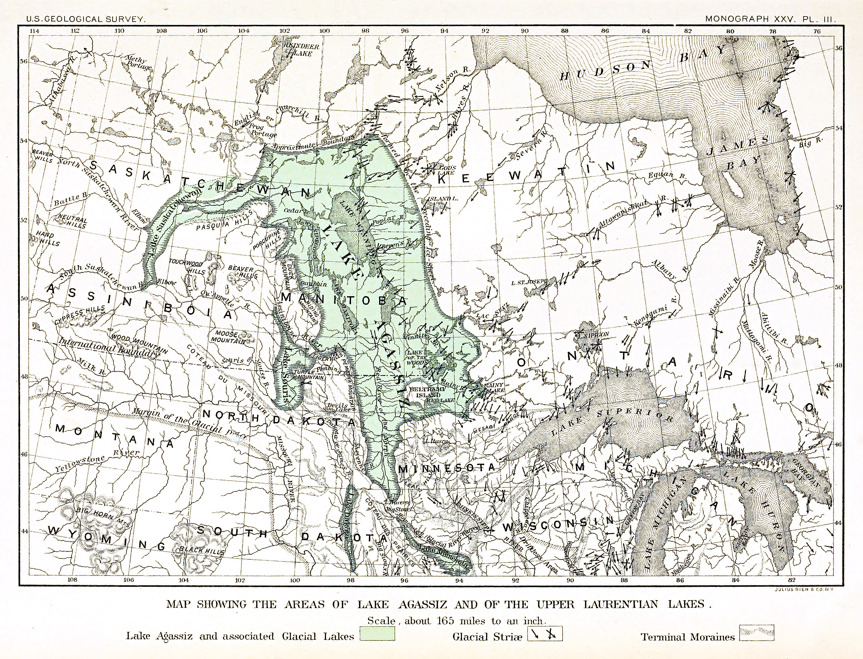
Map of the extent of glacial en:Lake Agassiz.
Bibliographical information: Upham, Warren. "The Glacial Lake Agassiz" archive copy at the Wayback Machine. Plate III. Monographs of the en:United States Geological Survey: Volume XXV. Washington Government Printing Office: Washington, 1895.
|
|
檔案歷史
點選日期/時間以檢視該時間的檔案版本。
| 日期/時間 | 縮圖 | 尺寸 | 使用者 | 備註 | |
|---|---|---|---|---|---|
| 目前 | 2015年8月13日 (四) 23:17 | | 2,832 × 2,163(6.82 MB) | Themadchopper | larger etc. |
| 2005年9月8日 (四) 00:00 |  | 938 × 713(309 KB) | L.m.k | Copied from the English Wikipedia. Original comment below: Map of the extent of glacial en:Lake Agassiz. Bibliographical information: Upham, Warren. [http://www.lib.ndsu.nodak.edu/govdocs/text/lakeagassiz/ "The Glacial Lake Agassiz"]. Plate III. M |
檔案用途
下列頁面有用到此檔案:
全域檔案使用狀況
以下其他 wiki 使用了這個檔案:
- ar.wikipedia.org 的使用狀況
- be.wikipedia.org 的使用狀況
- bg.wikipedia.org 的使用狀況
- ca.wikipedia.org 的使用狀況
- cs.wikipedia.org 的使用狀況
- de.wikipedia.org 的使用狀況
- en.wikipedia.org 的使用狀況
- eo.wikipedia.org 的使用狀況
- es.wikipedia.org 的使用狀況
- fi.wikipedia.org 的使用狀況
- fr.wikipedia.org 的使用狀況
- it.wikipedia.org 的使用狀況
- ja.wikipedia.org 的使用狀況
- ka.wikipedia.org 的使用狀況
- lv.wikipedia.org 的使用狀況
- ms.wikipedia.org 的使用狀況
- nl.wikipedia.org 的使用狀況
- nn.wikipedia.org 的使用狀況
- no.wikipedia.org 的使用狀況
- pl.wikipedia.org 的使用狀況
- pt.wikipedia.org 的使用狀況
- ru.wikipedia.org 的使用狀況
- sh.wikipedia.org 的使用狀況
- simple.wikipedia.org 的使用狀況
- sk.wikipedia.org 的使用狀況
- sl.wikipedia.org 的使用狀況
- sq.wikipedia.org 的使用狀況
- tr.wikipedia.org 的使用狀況
- uk.wikipedia.org 的使用狀況
- vi.wikipedia.org 的使用狀況
- www.wikidata.org 的使用狀況