
File:Asia in 1345.svg

此 SVG 檔案的 PNG 預覽的大小:788 × 600 像素。 其他解析度:316 × 240 像素 | 631 × 480 像素 | 1,009 × 768 像素 | 1,280 × 974 像素 | 2,560 × 1,948 像素 | 1,100 × 837 像素。
原始檔案 (SVG 檔案,表面大小:1,100 × 837 像素,檔案大小:1.02 MB)
摘要
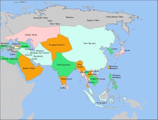
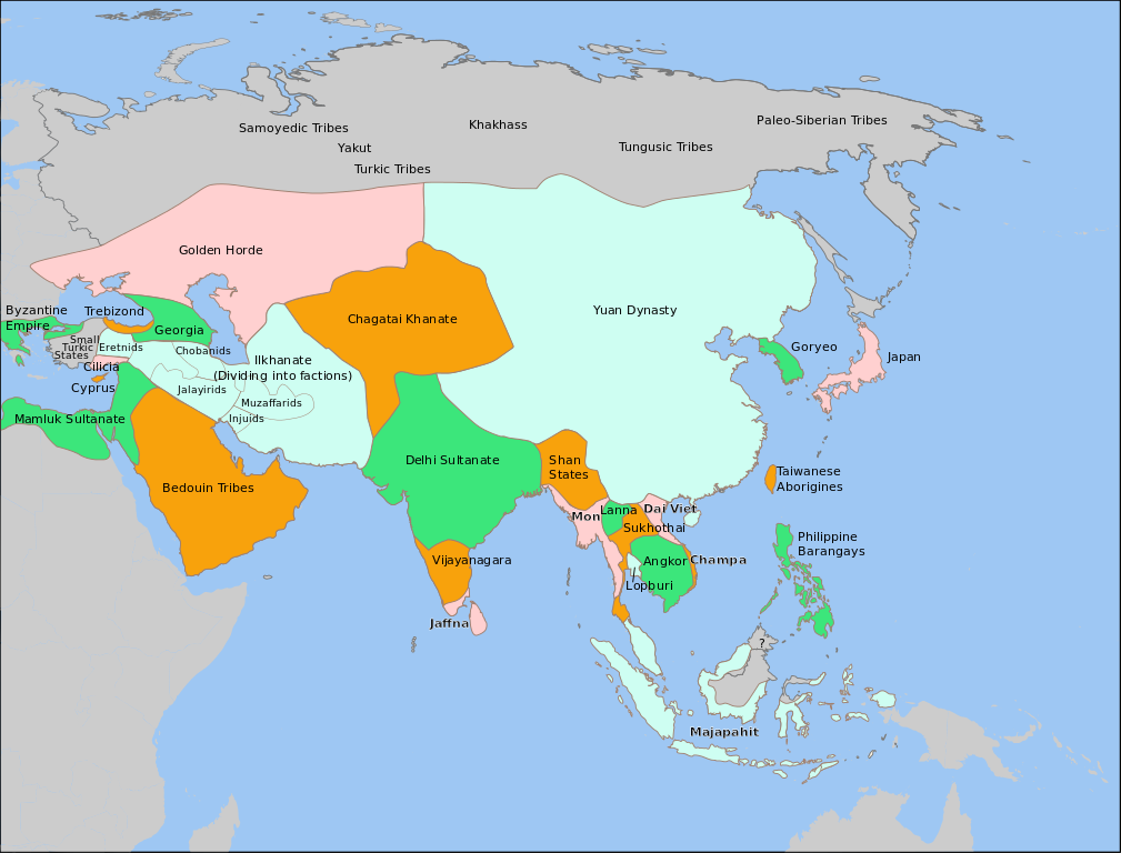
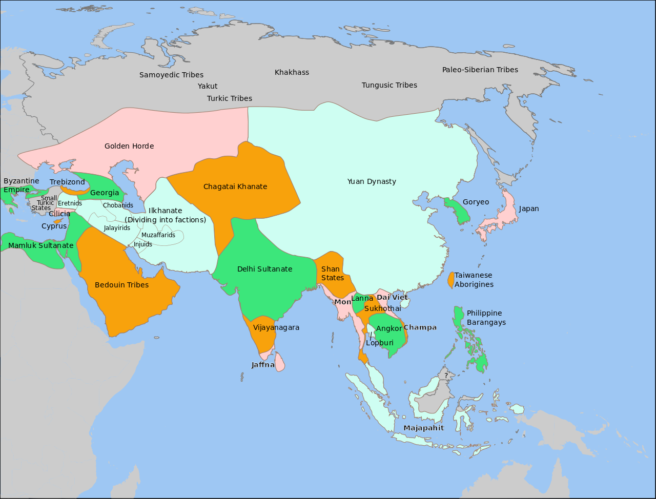
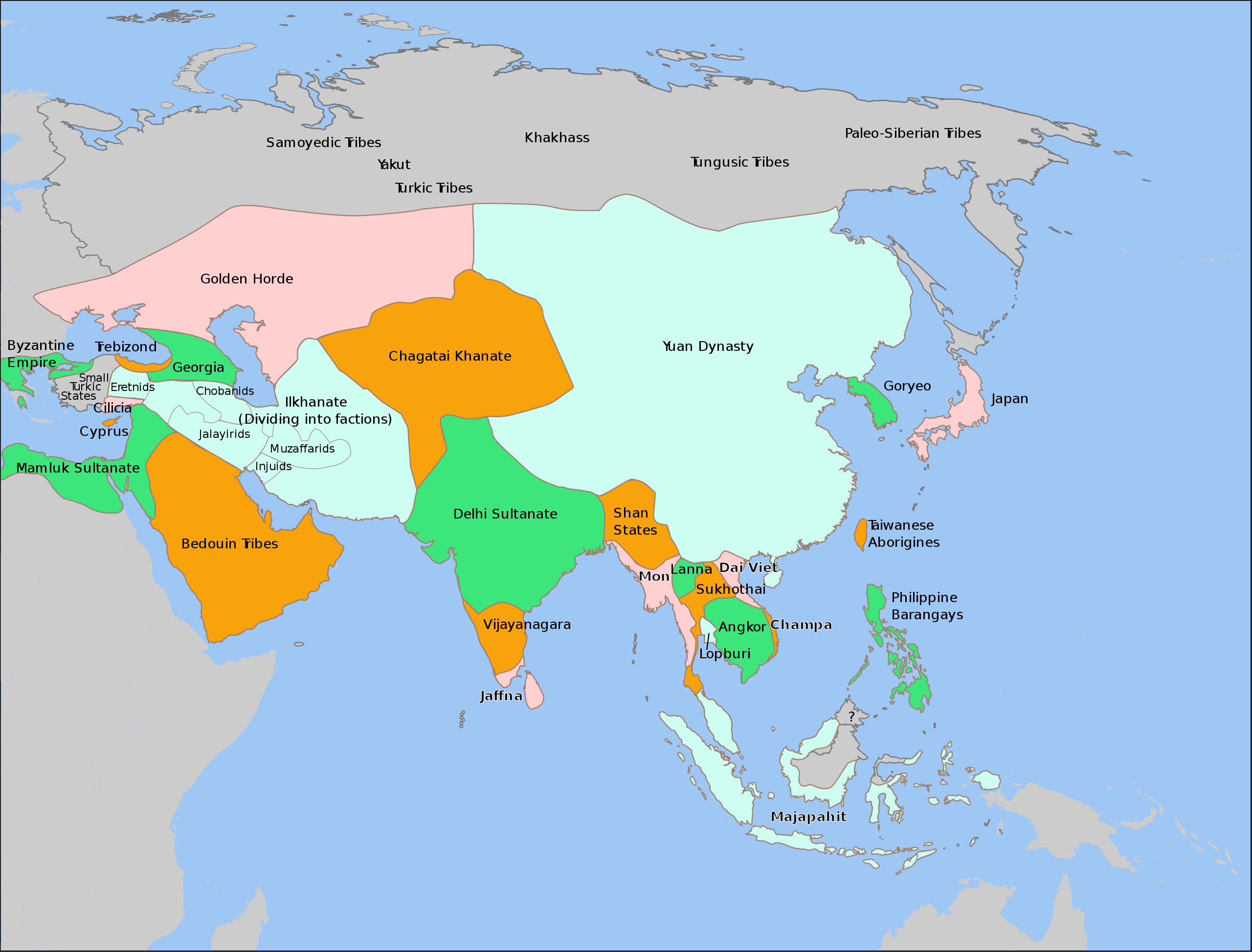
| 描述 | Aproximate outlines of nations in Asia in 1345. Please report any errors on the talk page, or on my talk page. |
| 日期 | |
| 來源 | various articles and maps on Wikipedia and the internet, including Image:PremongolEurasia.png, Image:Europe in 1345.png, Image:Mongol Empire map.gif, en:Image:Majapahit-map.jpg, en:Image:Chupanid - Jalayerid dynasty 1337–1432 ad.PNG, en:Image:IranaftertheIlkhanate.png, and Map of 13th Century Thai Kingdoms. |
| 作者 |

|
This SVG file contains embedded text that can be translated into your language, using any capable SVG editor, text editor or the SVG Translate tool. For more information see: About translating SVG files. |
授權條款
| 我,此作品的版權所有人,釋出此作品至公共領域。此授權條款在全世界均適用。 這可能在某些國家不合法,如果是的話: 我授予任何人有權利使用此作品於任何用途,除受法律約束外,不受任何限制。 |
檔案歷史
點選日期/時間以檢視該時間的檔案版本。
| 日期/時間 | 縮圖 | 尺寸 | 使用者 | 備註 | |
|---|---|---|---|---|---|
| 目前 | 2013年12月31日 (二) 03:48 | | 1,100 × 837(1.02 MB) | Garam | remove the CPOV. |
| 2012年12月21日 (五) 11:37 |  | 1,100 × 837(1.25 MB) | Coldhappy | Correct hokkaidho,choson peninsula situation. | |
| 2011年5月9日 (一) 17:14 |  | 1,100 × 837(1.02 MB) | Globulenoire | '''Hokkaïdo''' wasn't yet colonized by Japanese, and '''Cilicia''' wasn't as big | |
| 2008年9月16日 (二) 20:05 |  | 1,100 × 837(1.03 MB) | Wengier | adjust pos | |
| 2008年9月16日 (二) 17:21 |  | 1,100 × 837(1.03 MB) | Wengier | text pos | |
| 2008年9月16日 (二) 17:16 |  | 1,100 × 837(1.03 MB) | Wengier | fix on Shan | |
| 2008年9月16日 (二) 03:58 |  | 1,100 × 837(1.02 MB) | Wengier | small fix on Hainan | |
| 2008年9月16日 (二) 03:37 |  | 1,100 × 837(1.02 MB) | Wengier | slight fix from original | |
| 2008年2月10日 (日) 20:46 |  | 1,100 × 837(1.02 MB) | Teaandcrumpets | turned it into a four-color map using colors suggested here. Soon I will upload a new version of [[:Im | |
| 2007年12月29日 (六) 01:50 |  | 1,100 × 837(1.01 MB) | Teaandcrumpets | {{Information |Description=Aproximate outlines of nations in Asia in 1345. Please report any errors on the talk page. |Source=various articles and maps on Wikipedia and the internet, including Image:PremongolEurasia.png, Image:Europe in 1345.png |
檔案用途
沒有使用此檔案的頁面。
全域檔案使用狀況
以下其他 wiki 使用了這個檔案:
- ba.wikipedia.org 的使用狀況
- bn.wikipedia.org 的使用狀況
- en.wikipedia.org 的使用狀況
- fr.wikipedia.org 的使用狀況
- ja.wikipedia.org 的使用狀況
- nl.wikipedia.org 的使用狀況
- nn.wikipedia.org 的使用狀況
- ru.wikipedia.org 的使用狀況
- sl.wikipedia.org 的使用狀況
- ur.wikipedia.org 的使用狀況
- vi.wikipedia.org 的使用狀況