
File:Brands Hatch.svg

此 SVG 檔案的 PNG 預覽的大小:493 × 600 像素。 其他解析度:197 × 240 像素 | 395 × 480 像素 | 631 × 768 像素 | 842 × 1,024 像素 | 1,684 × 2,048 像素 | 1,198 × 1,457 像素。
原始檔案 (SVG 檔案,表面大小:1,198 × 1,457 像素,檔案大小:53 KB)
摘要
| 描述 |
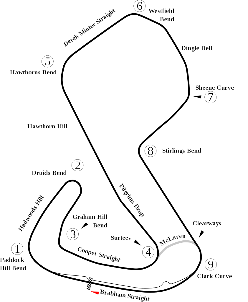
English: Track map of Brands Hatch. |
| 日期 | |
| 來源 | 自己的作品 |
| 作者 | Will Pittenger |
| 其他版本 |
|

| 拍攝地點 | | 位於此地的本圖片與其他圖片: OpenStreetMap |
|---|
授權條款
| 我,此作品的版權所有人,釋出此作品至公共領域。此授權條款在全世界均適用。 這可能在某些國家不合法,如果是的話: 我授予任何人有權利使用此作品於任何用途,除受法律約束外,不受任何限制。 |
檔案歷史
點選日期/時間以檢視該時間的檔案版本。
| 日期/時間 | 縮圖 | 尺寸 | 使用者 | 備註 | |
|---|---|---|---|---|---|
| 目前 | 2012年7月7日 (六) 15:10 | | 1,198 × 1,457(53 KB) | Aegidian | Very minor correction to text at Hailwoods Hill. |
| 2012年7月7日 (六) 15:04 |  | 1,198 × 1,457(54 KB) | Aegidian | Minor corrections to the names of Hawthorns Bend and Derek Minter straight, removal of old Dingle Dell Corner and replacement with current Sheene Curve. | |
| 2008年7月15日 (二) 06:44 |  | 1,198 × 1,457(54 KB) | Will Pittenger | This new version gets around a Mediawiki bug that prevents it from handing Text on paths correctly. It does so by converting such text into path objects. If you need to edit the text in question, please use the previous version. | |
| 2008年7月15日 (二) 06:40 |  | 1,198 × 1,457(45 KB) | Will Pittenger | {{Information |Description={{en|1=Track map of w:Brands Hatch.}} |Source=Own work by uploader |Author=Will Pittenger |Date=7-15-2008 |Permission= |other_versions=<gallery>Image:Brands Hatch.png|PNG version for those with brows |
檔案用途
下列頁面有用到此檔案:
全域檔案使用狀況
以下其他 wiki 使用了這個檔案:
- af.wikipedia.org 的使用狀況
- ar.wikipedia.org 的使用狀況
- ast.wikipedia.org 的使用狀況
- bg.wikipedia.org 的使用狀況
- bn.wikipedia.org 的使用狀況
- br.wikipedia.org 的使用狀況
- en.wikipedia.org 的使用狀況
- List of A1 Grand Prix circuits
- User talk:Chubbennaitor/archive2
- User talk:Barkjon/Archive 2
- Wikipedia:WikiProject Formula One/Newsletter/200808
- User talk:Hellboy2hell/archive2
- User talk:NapHit/Archive 1
- User talk:4u1e/archive5
- User talk:Typ932/Archive 3
- User talk:Midgrid/Archive 6
- Formula Ford Festival
- User talk:Thelb4/Archive 5
- User talk:Chubbennaitor/Archive7
- User talk:Readro/Archive 3
- Rothmans 50,000
- User talk:Donnie Park/Archive 1
- User talk:The359/Archive 4
- List of Superleague Formula circuits
- 2009 Brands Hatch Formula Two round
- User talk:Cs-wolves/Archive 3
- User talk:Bam123456789/Archive 1
- 2010 Brands Hatch Formula Two round
- User talk:Sage Callahan/Archive 1
- User talk:Cdhaptomos/Archive 1
- User:FactualCollector7d1/sandbox
- User talk:Spenalzo/Archive/2008
- User talk:Clyde1998/Archive/2008
- es.wikipedia.org 的使用狀況
- eu.wikipedia.org 的使用狀況
- fa.wikipedia.org 的使用狀況
- fi.wikipedia.org 的使用狀況
- fr.wikipedia.org 的使用狀況
檢視此檔案的更多全域使用狀況。