
File:California Interstate 280.svg

此 SVG 檔案的 PNG 預覽的大小:800 × 444 像素。 其他解析度:320 × 178 像素 | 640 × 356 像素 | 1,024 × 569 像素 | 1,280 × 711 像素 | 2,560 × 1,422 像素 | 1,152 × 640 像素。
原始檔案 (SVG 檔案,表面大小:1,152 × 640 像素,檔案大小:399 KB)
摘要
| 描述 |
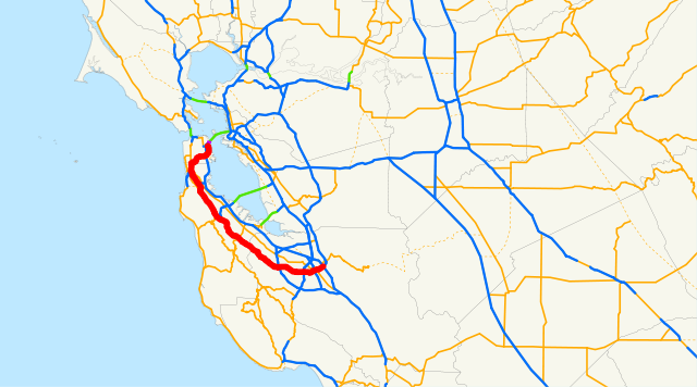
English: A map of Interstate 280 — in the western the San Francisco Bay Area, California.
|
| 來源 | Email me if you would like a copy of the GIS data I created for the highways. |
| 作者 | User:NE2 |
Sources: BTS North American Transportation Atlas Data archive copy at the Wayback Machine, Caltrans State Truck Route List (XLS file), Caltrans Log of Bridges on State Highways, All Caltrans Traffic Volumes on CSHS, California State Legislature Definitions of Routes
授權條款
| 我,此作品的版權所有人,釋出此作品至公共領域。此授權條款在全世界均適用。 這可能在某些國家不合法,如果是的話: 我授予任何人有權利使用此作品於任何用途,除受法律約束外,不受任何限制。 |
檔案歷史
點選日期/時間以檢視該時間的檔案版本。
| 日期/時間 | 縮圖 | 尺寸 | 使用者 | 備註 | |
|---|---|---|---|---|---|
| 目前 | 2007年12月19日 (三) 23:57 | | 1,152 × 640(399 KB) | NE2 | == Summary == This is a map of Interstate 280 in California, with unconstructed parts in purple. Email me if you would like a copy of the GIS data I created for the highways. Category:Interstate 280 (California) [[Category:M |
檔案用途
下列頁面有用到此檔案:
全域檔案使用狀況
以下其他 wiki 使用了這個檔案:
- de.wikipedia.org 的使用狀況
- es.wikipedia.org 的使用狀況
- fi.wikipedia.org 的使用狀況
- fr.wikipedia.org 的使用狀況
- nl.wikipedia.org 的使用狀況
- www.wikidata.org 的使用狀況