
File:Cape Gracias a Dios.jpg

預覽大小:375 × 600 像素。 其他解析度:150 × 240 像素 | 300 × 480 像素 | 480 × 768 像素 | 1,200 × 1,920 像素。
原始檔案 (1,200 × 1,920 像素,檔案大小:1.46 MB,MIME 類型:image/jpeg)
摘要
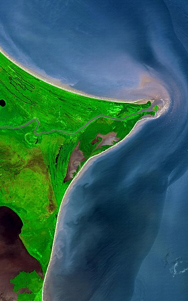
| 描述 | Around 15 degrees North, a rounded point of land juts out into the Caribbean Sea from the Central American isthmus. This low-lying, wet area is called the Mosquito Coast, a corruption of the tribal name of some of the area’s native people, the Miskito. The area includes parts of Honduras (north) and Nicaragua (south). Between the two countries flows the Coco River, which empties into the Caribbean at Cape Gracias á Dios. |
| 日期 | |
| 來源 |
http://earthobservatory.nasa.gov/Newsroom/NewImages/images.php3?img_id=17232
|
| 作者 | NASA/GSFC/METI/ERSDAC/JAROS, and U.S./Japan ASTER Science Team |
授權條款
| 本作品由NASA創作,屬於公有領域。根據NASA的版權政策:“NASA的創作除非另有聲明否則不受版權保護。”(參見:Template:PD-USGov/zh,NASA版權政策或JPL圖像使用政策) | ||
 |
警告:
|
檔案歷史
點選日期/時間以檢視該時間的檔案版本。
| 日期/時間 | 縮圖 | 尺寸 | 使用者 | 備註 | |
|---|---|---|---|---|---|
| 目前 | 2022年8月12日 (五) 20:53 | | 1,200 × 1,920(1.46 MB) | Thecaribbeancoast | Uploaded a more clearer and bigger photo |
| 2019年1月7日 (一) 22:35 |  | 800 × 600(216 KB) | Cptmrmcmillan | Color adjusted to make Coco River visible. Caribbean Sea labelled. Image resized to 800x600. | |
| 2007年6月14日 (四) 13:10 |  | 540 × 405(66 KB) | Ninane | {{Information |Description=Mosquito Coast and Cabo Gracias a Dios |Source=http://en.wikipedia.org/w/index.php?title=Image:Mosquito_coast.jpg&oldid=46439385 |Date=http://en.wikipedia.org/w/index.php?title=Image:Mosquito_coast.jpg&oldid=46439385 |Author=htt |
檔案用途
下列2個頁面有用到此檔案:
全域檔案使用狀況
以下其他 wiki 使用了這個檔案:
- ar.wikipedia.org 的使用狀況
- ast.wikipedia.org 的使用狀況
- ca.wikipedia.org 的使用狀況
- ceb.wikipedia.org 的使用狀況
- cs.wikipedia.org 的使用狀況
- cv.wikipedia.org 的使用狀況
- de.wikipedia.org 的使用狀況
- el.wikipedia.org 的使用狀況
- en.wikipedia.org 的使用狀況
- eo.wikipedia.org 的使用狀況
- es.wikipedia.org 的使用狀況
- eu.wikipedia.org 的使用狀況
- fi.wikipedia.org 的使用狀況
- fr.wikipedia.org 的使用狀況
- gl.wikipedia.org 的使用狀況
- hu.wikipedia.org 的使用狀況
- incubator.wikimedia.org 的使用狀況
- it.wikipedia.org 的使用狀況
- ja.wikipedia.org 的使用狀況
- ka.wikipedia.org 的使用狀況
- la.wikipedia.org 的使用狀況
- lt.wikipedia.org 的使用狀況
- mt.wikipedia.org 的使用狀況
- nds.wikipedia.org 的使用狀況
- nl.wikipedia.org 的使用狀況
檢視此檔案的更多全域使用狀況。