
File:Countries & Territories by estimated PPP GDP in 2020.png

預覽大小:800 × 393 像素。 其他解析度:320 × 157 像素 | 640 × 314 像素 | 1,024 × 503 像素 | 1,280 × 629 像素 | 2,560 × 1,258 像素 | 6,300 × 3,095 像素。
原始檔案 (6,300 × 3,095 像素,檔案大小:1.63 MB,MIME 類型:image/png)
摘要
| 描述 |
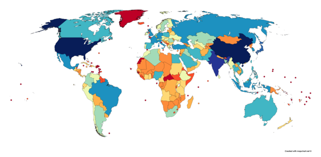
English: This is a map showing the countries & territories of the world by their estimated PPP GDP in 2020. I used the IMF's April 2020 WEO Database for most countries and dependencies, but for those without data, I used the latest data available from the CIA World Factbook (for North Korea, Venezuela, Cuba, Greenland, and tons of small island nations and territories. I made the map at mapchart.net |
| 日期 | |
| 來源 | 自己的作品 |
| 作者 | User:Abbasi786786 |
授權條款
我,本作品的著作權持有者,決定用以下授權條款發佈本作品:
此檔案採用創用CC 姓名標示-相同方式分享 4.0 國際授權條款。
- 您可以自由:
- 分享 – 複製、發佈和傳播本作品
- 重新修改 – 創作演繹作品
- 惟需遵照下列條件:
- 姓名標示 – 您必須指名出正確的製作者,和提供授權條款的連結,以及表示是否有對內容上做出變更。您可以用任何合理的方式來行動,但不得以任何方式表明授權條款是對您許可或是由您所使用。
- 相同方式分享 – 如果您利用本素材進行再混合、轉換或創作,您必須基於如同原先的相同或兼容的條款,來分布您的貢獻成品。
檔案歷史
點選日期/時間以檢視該時間的檔案版本。
| 日期/時間 | 縮圖 | 尺寸 | 使用者 | 備註 | |
|---|---|---|---|---|---|
| 目前 | 2020年4月23日 (四) 20:51 | | 6,300 × 3,095(1.63 MB) | Abbasi786786 | Uploaded own work with UploadWizard |
檔案用途
沒有使用此檔案的頁面。
全域檔案使用狀況
以下其他 wiki 使用了這個檔案:
- sv.wikipedia.org 的使用狀況
- tr.wikipedia.org 的使用狀況
- uk.wikipedia.org 的使用狀況
- zh-yue.wikipedia.org 的使用狀況