
File:Dcaairportmap.png

預覽大小:597 × 599 像素。 其他解析度:239 × 240 像素 | 478 × 480 像素 | 1,000 × 1,004 像素。
原始檔案 (1,000 × 1,004 像素,檔案大小:382 KB,MIME 類型:image/png)
摘要
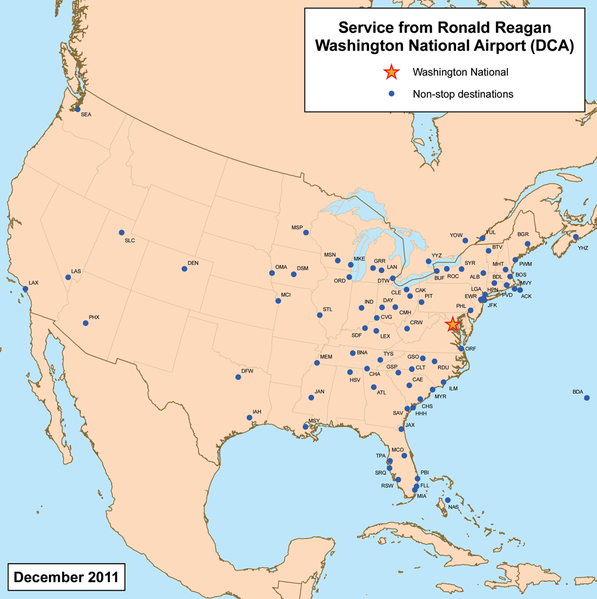
| 描述 | This is a route map for Ronald Reagan Washington National Airport as of May 2009. Map is an Azimuthal equidistant projection centered on the airport so straight lines from Washington are along great circle routes. Source. |
| 日期 | 2007年3月19日 (原始上傳日期) |
| 來源 | No machine-readable source provided. Own work assumed (based on copyright claims). |
| 作者 | No machine-readable author provided. Kmusser assumed (based on copyright claims). |
授權條款
我,本作品的著作權持有者,決定用以下授權條款發佈本作品:
此檔案採用創用CC 姓名標示-相同方式分享 3.0 未在地化版本授權條款。
- 您可以自由:
- 分享 – 複製、發佈和傳播本作品
- 重新修改 – 創作演繹作品
- 惟需遵照下列條件:
- 姓名標示 – 您必須指名出正確的製作者,和提供授權條款的連結,以及表示是否有對內容上做出變更。您可以用任何合理的方式來行動,但不得以任何方式表明授權條款是對您許可或是由您所使用。
- 相同方式分享 – 如果您利用本素材進行再混合、轉換或創作,您必須基於如同原先的相同或兼容的條款,來分布您的貢獻成品。
檔案歷史
點選日期/時間以檢視該時間的檔案版本。
| 日期/時間 | 縮圖 | 尺寸 | 使用者 | 備註 | |
|---|---|---|---|---|---|
| 目前 | 2011年7月12日 (二) 02:09 | | 1,000 × 1,004(382 KB) | Kmusser | updated destinations |
| 2009年4月7日 (二) 16:02 |  | 1,000 × 1,000(365 KB) | Kmusser | Updated destinations | |
| 2007年3月19日 (一) 21:14 |  | 1,000 × 1,000(384 KB) | Kmusser | corrected spelling | |
| 2007年3月19日 (一) 19:24 |  | 1,000 × 1,000(337 KB) | Kmusser | == Summary == This is a route map for Ronald Reagan Washington National Airport as of March 2007. Map is an Azimuthal equidistant projection centered on the airpor |
檔案用途
下列頁面有用到此檔案:
全域檔案使用狀況
以下其他 wiki 使用了這個檔案:
- de.wikipedia.org 的使用狀況
- en.wikipedia.org 的使用狀況
- no.wikipedia.org 的使用狀況