
File:Dromaius novaehollandiae map distribution 2.svg

此 SVG 檔案的 PNG 預覽的大小:736 × 600 像素。 其他解析度:295 × 240 像素 | 589 × 480 像素 | 942 × 768 像素 | 1,257 × 1,024 像素 | 2,513 × 2,048 像素 | 1,108 × 903 像素。
原始檔案 (SVG 檔案,表面大小:1,108 × 903 像素,檔案大小:114 KB)
摘要
| 描述 |
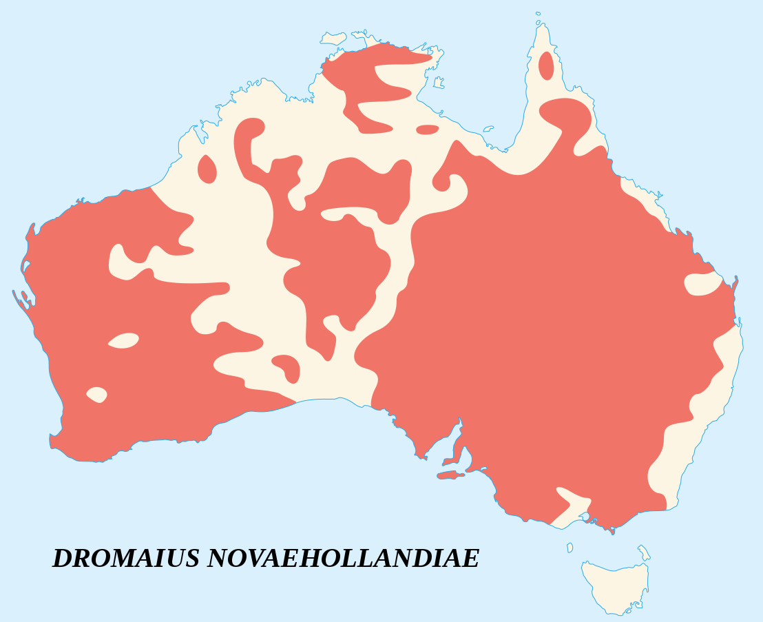
English: Emu's recorded observations map (Dromaius Novaehollandiae).
Areas where emu has been recorded. Français : Carte d'observations de l'Émeu d'Australie (Dromaius Novaehollandiae).
Zones où des émeus ont été observés. |
||
| 日期 | |||
| 來源 |
English:
Français : |
||
| 作者 | Sémhur (talk) | ||
| 姓名標示 (由许可协议要求) | © Sémhur / Wikimedia Commons / | ||
| SVG | W3C-validity not checked.
|
||
| Atelier graphique |

| 拍攝地點 | | 位於此地的本圖片與其他圖片: OpenStreetMap |
|---|
授權條款
我,本作品的著作權持有者,決定用以下授權條款發佈本作品:
| 公共版權:本藝術作品是自由的,您可以依據自由藝術作品許可協議的條款傳播和/或修改本藝術作品。您可以在Copyleft Attitude網站或其他網站找到該許可協議的樣本。 |
This file is licensed under the Creative Commons Attribution-Share Alike Attribution-Share Alike 4.0 International, 3.0 Unported, 2.5 Generic, 2.0 Generic and 1.0 Generic license.
- 您可以自由:
- 分享 – 複製、發佈和傳播本作品
- 重新修改 – 創作演繹作品
- 惟需遵照下列條件:
- 姓名標示 – 您必須指名出正確的製作者,和提供授權條款的連結,以及表示是否有對內容上做出變更。您可以用任何合理的方式來行動,但不得以任何方式表明授權條款是對您許可或是由您所使用。
- 相同方式分享 – 如果您利用本素材進行再混合、轉換或創作,您必須基於如同原先的相同或兼容的條款,來分布您的貢獻成品。
您可以選擇您需要的授權條款。
檔案歷史
點選日期/時間以檢視該時間的檔案版本。
| 日期/時間 | 縮圖 | 尺寸 | 使用者 | 備註 | |
|---|---|---|---|---|---|
| 目前 | 2007年6月25日 (一) 15:09 | | 1,108 × 903(114 KB) | Sémhur | better coast lines |
| 2007年6月24日 (日) 11:29 |  | 1,108 × 903(72 KB) | Sémhur | {{Information |Description= {{fr|Carte d'observations de l'émeu (''Dromaius Novaehollandiae'').<br/>Légende : en marron, zones où des émeus ont été observés.}} {{en|Emu's recorded observations map (''Dromaius Novaehollandiae'').<br/>Legend : maroon |
檔案用途
下列頁面有用到此檔案:
全域檔案使用狀況
以下其他 wiki 使用了這個檔案:
- an.wikipedia.org 的使用狀況
- ar.wikipedia.org 的使用狀況
- arz.wikipedia.org 的使用狀況
- ast.wikipedia.org 的使用狀況
- be.wikipedia.org 的使用狀況
- bg.wikipedia.org 的使用狀況
- bn.wikipedia.org 的使用狀況
- ca.wikipedia.org 的使用狀況
- ceb.wikipedia.org 的使用狀況
- cs.wikipedia.org 的使用狀況
- cy.wikipedia.org 的使用狀況
- de.wikipedia.org 的使用狀況
- en.wikipedia.org 的使用狀況
- eo.wikipedia.org 的使用狀況
- et.wikipedia.org 的使用狀況
- eu.wikipedia.org 的使用狀況
- fa.wikipedia.org 的使用狀況
- fi.wikipedia.org 的使用狀況
- ga.wikipedia.org 的使用狀況
- gl.wikipedia.org 的使用狀況
- gu.wikipedia.org 的使用狀況
- he.wikipedia.org 的使用狀況
- hr.wikipedia.org 的使用狀況
- hu.wikipedia.org 的使用狀況
- hy.wikipedia.org 的使用狀況
- id.wikipedia.org 的使用狀況
- incubator.wikimedia.org 的使用狀況
- is.wikipedia.org 的使用狀況
- ja.wikipedia.org 的使用狀況
- jv.wikipedia.org 的使用狀況
- ka.wikipedia.org 的使用狀況
- kk.wikipedia.org 的使用狀況
- kn.wikipedia.org 的使用狀況
- ko.wikipedia.org 的使用狀況
- kw.wikipedia.org 的使用狀況
- la.wikipedia.org 的使用狀況
- lt.wikipedia.org 的使用狀況
- lv.wikipedia.org 的使用狀況
- mk.wikipedia.org 的使用狀況
- ml.wikipedia.org 的使用狀況
- ms.wikipedia.org 的使用狀況
- my.wikipedia.org 的使用狀況
- nn.wikipedia.org 的使用狀況
- no.wikipedia.org 的使用狀況
- nv.wikipedia.org 的使用狀況
- or.wikipedia.org 的使用狀況
檢視此檔案的更多全域使用狀況。