
File:Durrani Empire 1747 1862 AD.png
預覽大小:768 × 600 像素。 其他解析度:307 × 240 像素 | 615 × 480 像素 | 832 × 650 像素。
原始檔案 (832 × 650 像素,檔案大小:105 KB,MIME 類型:image/png)
| 描述 |
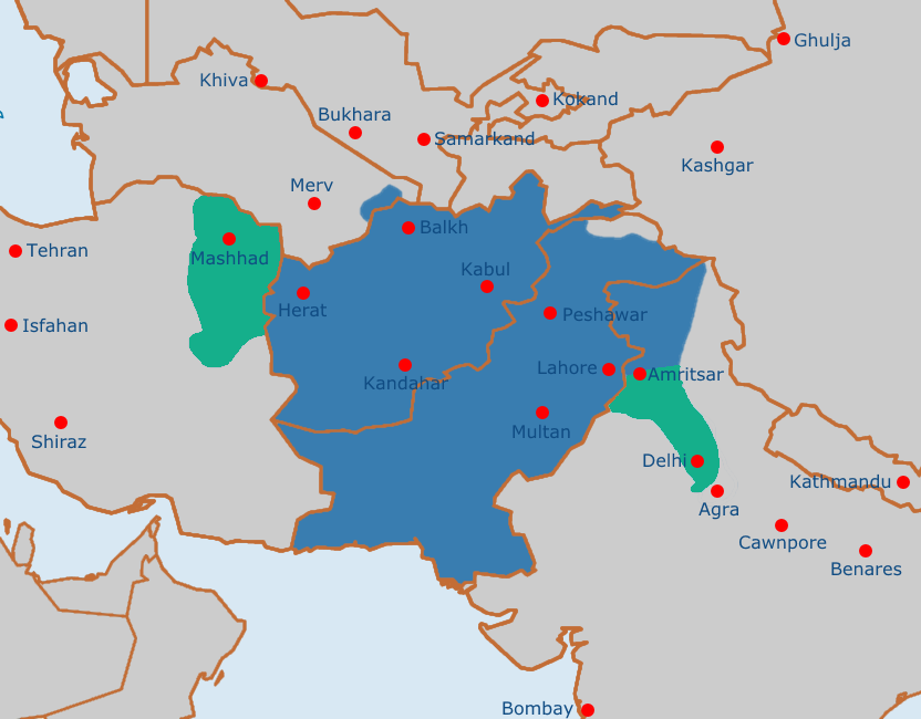
English: Map of the Afghan Durrani Empire at its greatest extent, circa late 1750s. In green is de facto (vassal) control. |
| 日期 | |
| 來源 | https://en.wikipedia.org/wiki/File:Safavid_Empire_1501_1722_AD.png |
| 作者 | Arab Hafez and edited by me. |
本檔案處於公有領域,因為Released into the public domain by the author.
|
檔案歷史
點選日期/時間以檢視該時間的檔案版本。
| 日期/時間 | 縮圖 | 尺寸 | 使用者 | 備註 | |
|---|---|---|---|---|---|
| 目前 | 2021年8月4日 (三) 11:51 | | 832 × 650(105 KB) | Weaveravel | De facto/vessel control and corrected Mashhad/Khorasan |
| 2021年8月4日 (三) 11:39 |  | 832 × 650(108 KB) | Weaveravel | Improved map layout and scale, added Delhi territory (as de facto control), fixed cities geographical positions | |
| 2021年7月26日 (一) 18:54 |  | 1,415 × 958(205 KB) | Weaveravel | Clearer, high quality map, more accurate labels and cities (denoting important ones) | |
| 2013年4月28日 (日) 14:27 |  | 620 × 429(22 KB) | HistoryofIran | {{subst:Upload marker added by en.wp UW}} {{Information |Description = {{en|Map of the Durrani Empire at it's greatest extent.}} |Source = https://en.wikipedia.org/wiki/File:Safavid_Empire_1501_1722_AD.png |Date = 28. April 2013. |Author = Arab Hafez a... |
檔案用途
下列頁面有用到此檔案:
全域檔案使用狀況
以下其他 wiki 使用了這個檔案:
- ar.wikipedia.org 的使用狀況
- ast.wikipedia.org 的使用狀況
- azb.wikipedia.org 的使用狀況
- az.wikipedia.org 的使用狀況
- be.wikipedia.org 的使用狀況
- bg.wikipedia.org 的使用狀況
- bn.wikipedia.org 的使用狀況
- bs.wikipedia.org 的使用狀況
- ca.wikipedia.org 的使用狀況
- cs.wikipedia.org 的使用狀況
- de.wikipedia.org 的使用狀況
- diq.wikipedia.org 的使用狀況
- el.wikipedia.org 的使用狀況
- en.wikipedia.org 的使用狀況
- eo.wikipedia.org 的使用狀況
- es.wikipedia.org 的使用狀況
- et.wikipedia.org 的使用狀況
- eu.wikipedia.org 的使用狀況
- fa.wikipedia.org 的使用狀況
- fi.wikipedia.org 的使用狀況
- fr.wikipedia.org 的使用狀況
- he.wikipedia.org 的使用狀況
- hi.wikipedia.org 的使用狀況
- hu.wikipedia.org 的使用狀況
- hy.wikipedia.org 的使用狀況
- it.wikipedia.org 的使用狀況
- ka.wikipedia.org 的使用狀況
- kn.wikipedia.org 的使用狀況
- lt.wikipedia.org 的使用狀況
- mn.wikipedia.org 的使用狀況
- nl.wikipedia.org 的使用狀況
- nn.wikipedia.org 的使用狀況
- pt.wikipedia.org 的使用狀況
- ru.wikipedia.org 的使用狀況
- sk.wikipedia.org 的使用狀況
- sv.wikipedia.org 的使用狀況
- ta.wikipedia.org 的使用狀況
- tg.wikipedia.org 的使用狀況
- vi.wikipedia.org 的使用狀況
檢視此檔案的更多全域使用狀況。