
File:EasterIsland 1772.JPG

預覽大小:423 × 599 像素。 其他解析度:169 × 240 像素 | 339 × 480 像素 | 542 × 768 像素 | 723 × 1,024 像素 | 1,447 × 2,048 像素 | 3,750 × 5,308 像素。
原始檔案 (3,750 × 5,308 像素,檔案大小:2.53 MB,MIME 類型:image/jpeg)
摘要
| 描述 |
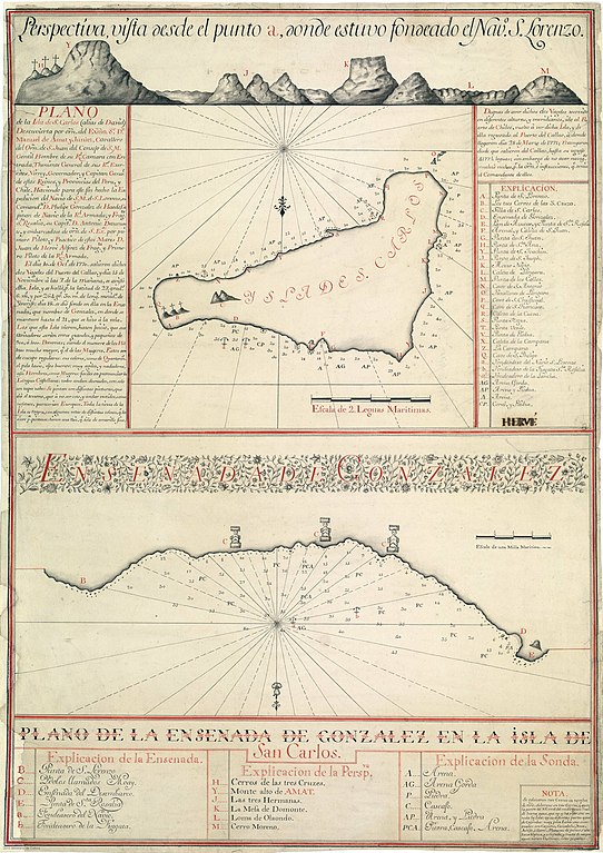
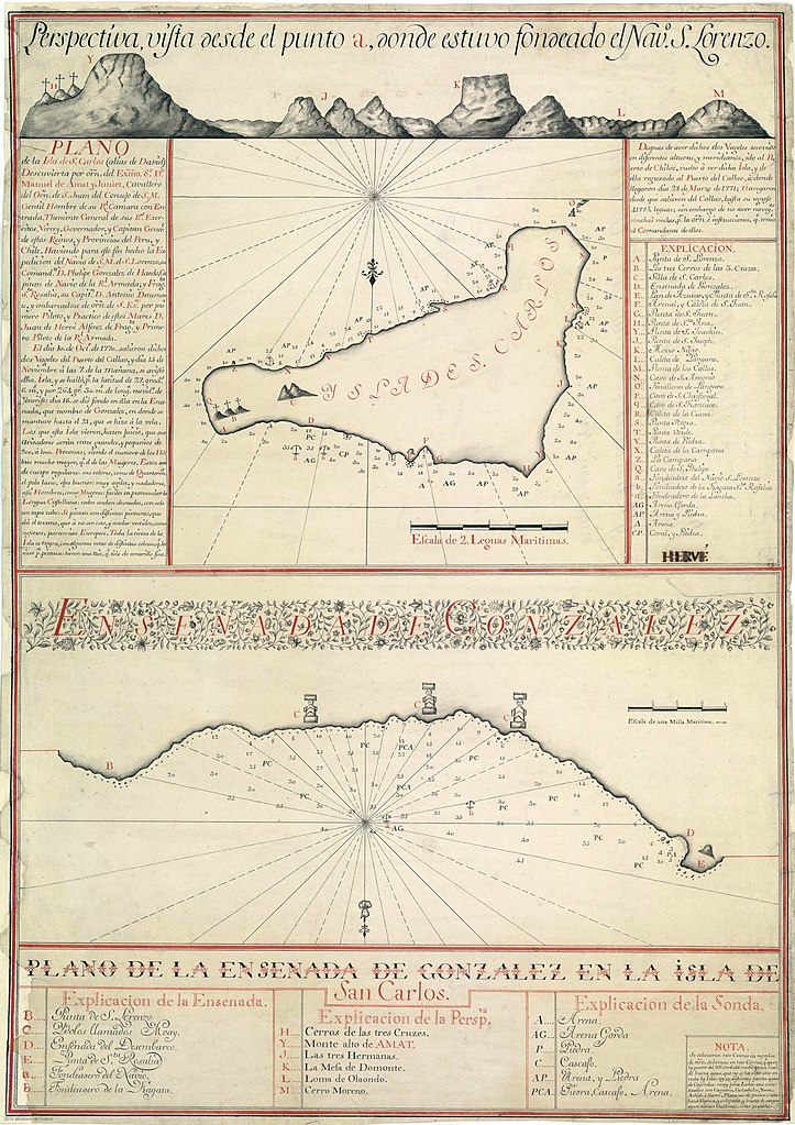
English: North down 1772 map of Easter Island (Isla de San Carlos) drawn by the 1772 Spanish expedition commanded by Felipe González de Haedo. Original in Madrid Naval Museum
Русский: Карта острова Пасхи, сделанная в 1772 году во время экспедиции Гонсалеса де Аэдо |
| 日期 | |
| 來源 | Per above |
| 作者 | Felipe González de Haedo |
授權條款
|
本作品在其來源國以及其他著作權期限是作者逝世後100年或以下的國家與地區屬於公有領域。 | |
| 此作品無已知的著作權限制,亦不受所有相關和鄰接的權利限制。 | |
Transwiki details
(All user names refer to en.wikipedia)
- 2007-04-19 11:02 Logares1 1285×1801×8 (614098 bytes) 1772 map of Easter Island (''Isla de San Carlos'') drawn by the 1772 Spanish expedition commanded by Felipe González de Ahedo. Original in Madrid Navla Museum
檔案歷史
點選日期/時間以檢視該時間的檔案版本。
| 日期/時間 | 縮圖 | 尺寸 | 使用者 | 備註 | |
|---|---|---|---|---|---|
| 目前 | 2022年10月8日 (六) 18:40 | | 3,750 × 5,308(2.53 MB) | Janitoalevic | Cropped 12 % horizontally using CropTool with precise mode. |
| 2020年8月15日 (六) 04:00 |  | 4,244 × 5,308(2.61 MB) | Fitmoos | more resolution and color | |
| 2007年5月10日 (四) 05:16 |  | 1,285 × 1,801(600 KB) | Lastman | {{Information |Description=North down 1772 map of Easter Island (''Isla de San Carlos'') drawn by the 1772 Spanish expedition commanded by Felipe González de Haedo. Original in Madrid Naval Museum |Source=Originally from [http://en.wikipedia.org en.wiki |
檔案用途
下列頁面有用到此檔案:
全域檔案使用狀況
以下其他 wiki 使用了這個檔案:
- ar.wikipedia.org 的使用狀況
- ast.wikipedia.org 的使用狀況
- bn.wikipedia.org 的使用狀況
- ckb.wikipedia.org 的使用狀況
- cs.wikipedia.org 的使用狀況
- en.wikipedia.org 的使用狀況
- es.wikipedia.org 的使用狀況
- fa.wikipedia.org 的使用狀況
- fr.wikipedia.org 的使用狀況
- it.wikipedia.org 的使用狀況
- ms.wikipedia.org 的使用狀況
- mzn.wikipedia.org 的使用狀況
- pl.wikipedia.org 的使用狀況
- ru.wikipedia.org 的使用狀況
- sk.wikipedia.org 的使用狀況
- sl.wikipedia.org 的使用狀況