
File:Enchanted rock 2006.jpg
無更高解析度可提供。
Enchanted_rock_2006.jpg (640 × 480 像素,檔案大小:59 KB,MIME 類型:image/jpeg)
摘要
| 描述 |
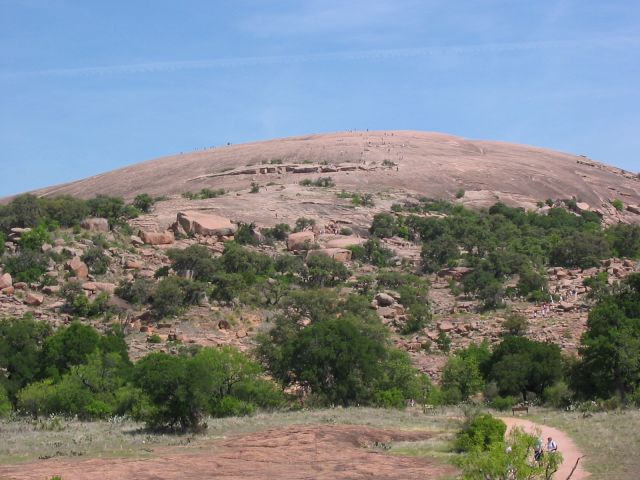
Enchanted Rock as viewed from the trail leading to the summit. People climbing on the summit (visible as dots) give an idea of the scale of the granite rock. Source: Photo taken by uploader, April 14, 2006. |
| 日期 | 2006年4月18日 (原始上傳日期) |
| 來源 | Transferred from en.wikipedia to Commons. |
| 作者 | 英文維基百科的Claygate |
| 目標地點 | | 位於此地的本圖片與其他圖片: OpenStreetMap |
|---|
授權條款
| 此作品已由其作者,英文維基百科的Claygate,釋出至公有領域。此授權條款在全世界均適用。 這可能在某些國家不合法,如果是的話: Claygate授予任何人有權利使用此作品於任何用途,除受法律約束外,不受任何限制。 |
原始上傳日誌
The original description page was here. All following user names refer to en.wikipedia.
- 2006-04-18 01:13 Claygate 640×480×8 (60062 bytes) Picture taken by uploader, April 14, 2006.
檔案歷史
點選日期/時間以檢視該時間的檔案版本。
| 日期/時間 | 縮圖 | 尺寸 | 使用者 | 備註 | |
|---|---|---|---|---|---|
| 目前 | 2007年4月24日 (二) 02:04 | | 640 × 480(59 KB) | Jomegat | {{Information |Description=Enchanted Rock as viewed from the trail leading to the summit. People climbing on the summit (visible as dots) give an idea of the scale of the granite rock. Source: Photo taken by uploader, April 14, 2006. |Source=Originally f |
檔案用途
全域檔案使用狀況
以下其他 wiki 使用了這個檔案:
- de.wikipedia.org 的使用狀況
- en.wikipedia.org 的使用狀況
- Llano, Texas
- Llano Uplift
- Enchanted Rock
- List of Texas state parks
- List of National Natural Landmarks in Texas
- National Register of Historic Places listings in Gillespie County, Texas
- National Register of Historic Places listings in Llano County, Texas
- National Register of Historic Places listings in the Alamo region of Texas: Other
- National Register of Historic Places listings in the Capital region of Texas: Other
- en.wikibooks.org 的使用狀況
- es.wikipedia.org 的使用狀況
- fa.wikipedia.org 的使用狀況
- fr.wikipedia.org 的使用狀況
- it.wikipedia.org 的使用狀況
- nl.wikipedia.org 的使用狀況
- sv.wikipedia.org 的使用狀況