
File:Flores map.png
無更高解析度可提供。
Flores_map.png (300 × 122 像素,檔案大小:21 KB,MIME 類型:image/png)

|
本圖片是以PNG、GIF或JPEG格式上傳。然而,其中包含的資料或訊息,應該重新建立成可縮放向量圖形(SVG)檔案,以更有效率或更準確的方式儲存。如有可能,請上傳本圖片的SVG格式版本。在上傳之後,請修改維基各姊妹計畫中所有使用舊版圖片的條目(列在圖像連結章節中),替換為新版圖片,並在舊圖片的描述頁中加入{{Vector version available|新圖片名稱.svg}}模板,同時移除本模板。
|
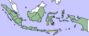
This image was copied from wikipedia:en. The original description was:
Map showing Flores Island within Indonesia
| 我,此作品的版權所有人,釋出此作品至公共領域。此授權條款在全世界均適用。 這可能在某些國家不合法,如果是的話: 我授予任何人有權利使用此作品於任何用途,除受法律約束外,不受任何限制。 |
| date/time | username | edit summary |
|---|---|---|
| 14:17, 14 March 2005 | *drew | (Map showing Flores Island within Indonesia) |
檔案歷史
點選日期/時間以檢視該時間的檔案版本。
| 日期/時間 | 縮圖 | 尺寸 | 使用者 | 備註 | |
|---|---|---|---|---|---|
| 目前 | 2007年2月2日 (五) 10:19 | 300 × 122(21 KB) | J. Patrick Fischer | The original image was copied from wikipedia:en. The image was corrected by user:J. Patrick Fischer (two islands east of Flores were wrong marked as part of Flores before). The original description was: Map showing Flores Island within Indonesia {{ | |
| 2006年10月10日 (二) 12:26 | 300 × 122(16 KB) | UtherSRG | Change color. | ||
| 2005年10月5日 (三) 12:27 | 300 × 122(15 KB) | ChongDae | This image was copied from wikipedia:en. The original description was: Map showing Flores Island within Indonesia {{PD}} {| border="1" ! date/time || username || edit summary |---- | 14:17, 14 March 2005 || *drew || <nowiki>(Map showing Flores Island wi |
檔案用途
下列頁面有用到此檔案:
全域檔案使用狀況
以下其他 wiki 使用了這個檔案:
- az.wikipedia.org 的使用狀況
- cy.wikipedia.org 的使用狀況
- el.wikipedia.org 的使用狀況
- en.wikipedia.org 的使用狀況
- en.wikivoyage.org 的使用狀況
- en.wiktionary.org 的使用狀況
- eo.wikipedia.org 的使用狀況
- fi.wikipedia.org 的使用狀況
- fr.wikipedia.org 的使用狀況
- gl.wikipedia.org 的使用狀況
- he.wikipedia.org 的使用狀況
- id.wikipedia.org 的使用狀況
- ilo.wikipedia.org 的使用狀況
- it.wikipedia.org 的使用狀況
- ko.wikipedia.org 的使用狀況
- min.wikipedia.org 的使用狀況
- ml.wikipedia.org 的使用狀況
- nl.wikipedia.org 的使用狀況
- nn.wikipedia.org 的使用狀況
- pt.wikipedia.org 的使用狀況
- tr.wikipedia.org 的使用狀況