
File:German Empire states map.svg

此 SVG 檔案的 PNG 預覽的大小:496 × 600 像素。 其他解析度:198 × 240 像素 | 397 × 480 像素 | 635 × 768 像素 | 847 × 1,024 像素 | 1,694 × 2,048 像素 | 1,042 × 1,260 像素。
原始檔案 (SVG 檔案,表面大小:1,042 × 1,260 像素,檔案大小:2.34 MB)
摘要
| 描述 |
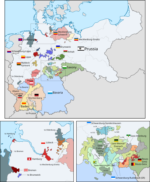
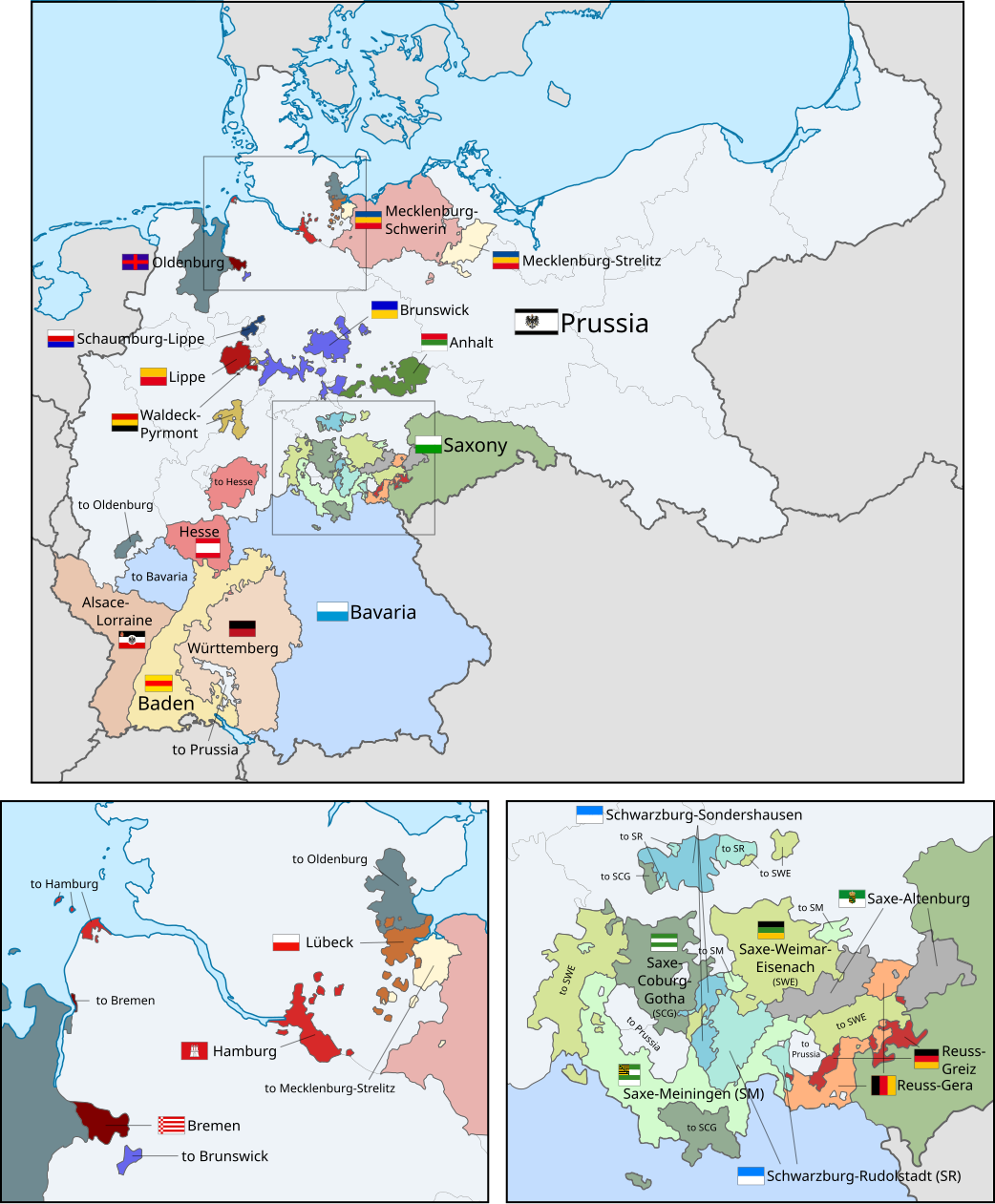
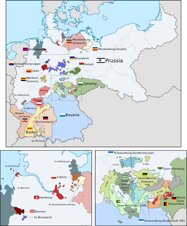
English: A map of the states of the German Empire, showing their location, flags and names in English. |
| 日期 | |
| 來源 |
本檔案衍生自: German Empire blank map.svg: |
| 作者 |
|
| 其他版本 |
|
| SVG開發 |


.svg)
.svg)
.svg)
.svg)
.svg)
.svg)
授權條款
我,本作品的著作權持有者,決定用以下授權條款發佈本作品:
此檔案採用創用CC 姓名標示-相同方式分享 3.0 未在地化版本授權條款。
- 您可以自由:
- 分享 – 複製、發佈和傳播本作品
- 重新修改 – 創作演繹作品
- 惟需遵照下列條件:
- 姓名標示 – 您必須指名出正確的製作者,和提供授權條款的連結,以及表示是否有對內容上做出變更。您可以用任何合理的方式來行動,但不得以任何方式表明授權條款是對您許可或是由您所使用。
- 相同方式分享 – 如果您利用本素材進行再混合、轉換或創作,您必須基於如同原先的相同或兼容的條款,來分布您的貢獻成品。
Code for clickable map
檔案歷史
點選日期/時間以檢視該時間的檔案版本。
| 日期/時間 | 縮圖 | 尺寸 | 使用者 | 備註 | |
|---|---|---|---|---|---|
| 目前 | 2024年4月26日 (五) 14:04 | | 1,042 × 1,260(2.34 MB) | Heiliges | File uploaded using svgtranslate tool (https://svgtranslate.toolforge.org/). Added translation for ko. |
| 2024年4月26日 (五) 13:55 |  | 1,042 × 1,260(2.34 MB) | Heiliges | File uploaded using svgtranslate tool (https://svgtranslate.toolforge.org/). Added translation for ko. | |
| 2024年4月26日 (五) 13:47 |  | 1,042 × 1,260(2.32 MB) | Heiliges | File uploaded using svgtranslate tool (https://svgtranslate.toolforge.org/). Added translation for ko. | |
| 2019年2月24日 (日) 02:43 |  | 1,042 × 1,260(2.31 MB) | Alphathon | Corrected Brunswick territory accidentally given to Anhalt | |
| 2015年11月4日 (三) 14:55 |  | 1,042 × 1,260(2.39 MB) | Alphathon | Slight optimisation | |
| 2015年11月4日 (三) 01:33 |  | 1,042 × 1,260(2.39 MB) | Alphathon | Another minor tweak | |
| 2015年11月4日 (三) 01:31 |  | 1,042 × 1,260(2.39 MB) | Alphathon | Tweaked colours | |
| 2015年11月3日 (二) 22:25 |  | 1,042 × 1,260(2.39 MB) | Alphathon | Corrected typo | |
| 2015年11月3日 (二) 11:51 |  | 1,042 × 1,260(2.39 MB) | Alphathon | {{Information |Description={{en|A map of the states of the en:German Empire, showing their location, flags and names in English.}} |Source={{Derived from|File:German Empire blank map.svg|display=50}} {{AttribSVG|Flagge Herzogtum Anhalt.svg|David... |
檔案用途
下列3個頁面有用到此檔案:
全域檔案使用狀況
以下其他 wiki 使用了這個檔案:
- ar.wikipedia.org 的使用狀況
- ast.wikipedia.org 的使用狀況
- az.wikipedia.org 的使用狀況
- ca.wikipedia.org 的使用狀況
- en.wikipedia.org 的使用狀況
- es.wikipedia.org 的使用狀況
- fi.wikipedia.org 的使用狀況
- he.wikipedia.org 的使用狀況
- hu.wikipedia.org 的使用狀況
- it.wikipedia.org 的使用狀況
- ko.wikipedia.org 的使用狀況
- nl.wikipedia.org 的使用狀況
- pt.wikipedia.org 的使用狀況
- sr.wikipedia.org 的使用狀況
- th.wikipedia.org 的使用狀況