
File:HK Route10 map.svg

此 SVG 檔案的 PNG 預覽的大小:800 × 582 像素。 其他解析度:320 × 233 像素 | 640 × 466 像素 | 1,024 × 746 像素 | 1,280 × 932 像素 | 2,560 × 1,864 像素 | 1,607 × 1,170 像素。
原始檔案 (SVG 檔案,表面大小:1,607 × 1,170 像素,檔案大小:155 KB)
摘要

|
這張圖片需要更新,因為:Update Route 6 section as TKO-LT tunnel opened in 2022 and rest of the route 6 will be opened in 2025.在這樣做的時候,您可以為該圖片加入時間戳。
|
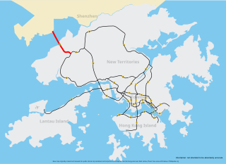
| 描述 | Map of Route 10, Hong Kong, coloured red |
| 日期 | |
| 來源 | self-made based on Image:Hong Kong Strategic Route Map.svg |
| 作者 | Raphaelmak |
授權條款
| 我,此作品的版權所有人,釋出此作品至公共領域。此授權條款在全世界均適用。 這可能在某些國家不合法,如果是的話: 我授予任何人有權利使用此作品於任何用途,除受法律約束外,不受任何限制。 |
檔案歷史
點選日期/時間以檢視該時間的檔案版本。
| 日期/時間 | 縮圖 | 尺寸 | 使用者 | 備註 | |
|---|---|---|---|---|---|
| 目前 | 2013年5月19日 (日) 21:02 | | 1,607 × 1,170(155 KB) | Jc86035 | Updated Route 8 |
| 2008年3月21日 (五) 06:02 |  | 1,607 × 1,170(155 KB) | Raphaelmak | Updating; thickening | |
| 2008年2月18日 (一) 13:11 |  | 1,607 × 1,170(155 KB) | Raphaelmak | == Summary == {{Information |Description=Map of w:Route 10 (Hong Kong), w:Hong Kong, coloured red |Source=self-made based on Image:Hong Kong Strategic Route Map.svg |Date=2008-02-18 |Author= Raphaelmak|Permission= |o |
檔案用途
沒有使用此檔案的頁面。
全域檔案使用狀況
以下其他 wiki 使用了這個檔案: