
File:Iceland's Mid-Atlantic Ridge during snow.jpg

預覽大小:800 × 483 像素。 其他解析度:320 × 193 像素 | 640 × 387 像素 | 1,024 × 619 像素 | 1,280 × 773 像素 | 2,560 × 1,546 像素 | 5,975 × 3,609 像素。
原始檔案 (5,975 × 3,609 像素,檔案大小:12.02 MB,MIME 類型:image/jpeg)
摘要
| 描述 |
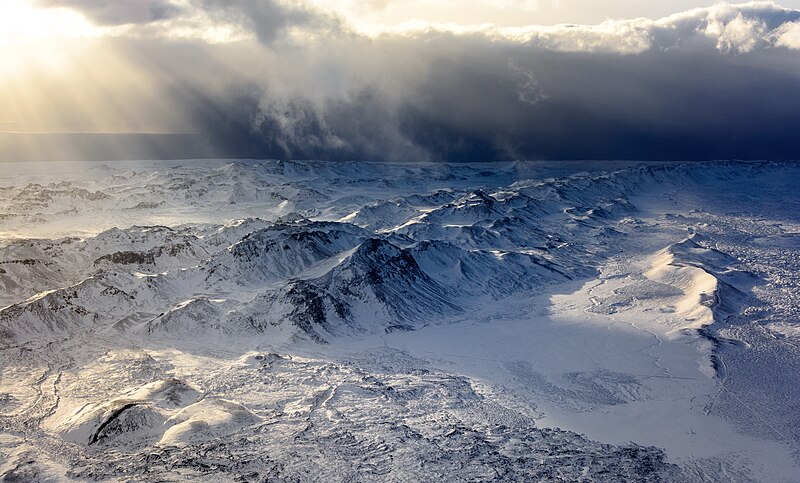
English: A shot taken from a plane over Iceland's south-western part of the mountain range caused by the Mid-Atlantic Ridge (Reykjanes Ridge). The shot is pointing towards the south-east (taken from above the sea).
Español: Foto aérea de la cadena montañosa de la península de Reykjanes en el suroeste de Islandia. La cadena montañosa es una continuación de la dorsal mesoatlántica (Reykjanes Ridge). La foto apunta hacia el sureste.
Українська: Аерознімок південно-західної частини гірського хребта Ісландії, як продовження Серединно-Атлантичного хребта (хр. Рейк'янес). |
||||
| 日期 | 攝於2018年2月6日, 14:38:59 | ||||
| 來源 | 自己的作品 | ||||
| 作者 |
|


| 拍攝地點 | | 位於此地的本圖片與其他圖片: OpenStreetMap |
|---|
評價
This image was selected as picture of the day on Wikimedia Commons for 14 September 2022. It was captioned as follows: English: A shot taken from a plane over Iceland's south-western part of the mountain range caused by the Mid-Atlantic Ridge (Reykjanes Ridge). Other languages:
Čeština: Letecký snímek části pohoří v jihozápadní části Islandu, které je zároveň součástí geologického útvaru Středoatlantského hřbetu. Deutsch: Blick aus einem Flugzeug auf den isländischen Reykjanesrücken, Teil des Mittelatlantischer Rücken. English: A shot taken from a plane over Iceland's south-western part of the mountain range caused by the Mid-Atlantic Ridge (Reykjanes Ridge). Español: Foto aérea de la cadena montañosa de la península de Reykjanes en el suroeste de Islandia. La cadena montañosa es una continuación de la dorsal mesoatlántica (Reykjanes Ridge). La foto apunta hacia el sureste (tomada desde arriba del mar). Français : La dorsale médio-atlantique vue d'Islande. Cette chaîne de montagne est essentiellement marine : ses pics les plus élevés forment des îles à la surface de l'océan Atlantique. Magyar: Repülőgépről készült felvétel Izland délnyugati része felett, a Közép-Atlanti-hátság (Reykjanesi hátság) okozta hegyvonulatról Nederlands: Luchtfoto van het IJslandse schiereiland Reykjanes. IJsland is een deel van de Mid-Atlantische Rug dat boven water uitsteekt. Português: Foto aérea da cordilheira da península de Reykjanes no sudoeste da Islândia. A cadeia montanhosa é uma continuação da dorsal mesoatlântica. Македонски: Прелет над венецот Рејкјанес во Исланд предизвикан од Средноатлантскиот Гребен. Українська: Аерознімок південно-західної частини гірського хребта Ісландії, як продовження Серединно-Атлантичного хребта (хр. Рейк'янес). |
|
|
授權條款
此檔案採用創用CC 姓名標示-相同方式分享 4.0 國際授權條款。
姓名標示: Bar Harel
- 您可以自由:
- 分享 – 複製、發佈和傳播本作品
- 重新修改 – 創作演繹作品
- 惟需遵照下列條件:
- 姓名標示 – 您必須指名出正確的製作者,和提供授權條款的連結,以及表示是否有對內容上做出變更。您可以用任何合理的方式來行動,但不得以任何方式表明授權條款是對您許可或是由您所使用。
- 相同方式分享 – 如果您利用本素材進行再混合、轉換或創作,您必須基於如同原先的相同或兼容的條款,來分布您的貢獻成品。
檔案歷史
點選日期/時間以檢視該時間的檔案版本。
| 日期/時間 | 縮圖 | 尺寸 | 使用者 | 備註 | |
|---|---|---|---|---|---|
| 目前 | 2018年6月16日 (六) 12:05 | | 5,975 × 3,609(12.02 MB) | Bharel | less NR |
| 2018年6月16日 (六) 11:43 |  | 5,975 × 3,609(11.9 MB) | Bharel | I need an IPS screen for dust spots. Resampled spots, reduced noise filter for bottom to preserve detail, added noise filter for top. | |
| 2018年6月16日 (六) 00:32 |  | 5,975 × 3,609(11.71 MB) | Bharel | sRGB | |
| 2018年6月16日 (六) 00:19 |  | 5,975 × 3,609(11.2 MB) | Bharel | Changed colorspace to AdobeRGB due to posterization | |
| 2018年6月15日 (五) 22:41 |  | 5,975 × 3,609(10.91 MB) | Bharel | Removed blob | |
| 2018年6月15日 (五) 22:31 |  | 5,975 × 3,609(10.92 MB) | Bharel | Super tiny denoise filter, hopefully won't hurt the overall quality and sharpness. | |
| 2018年6月15日 (五) 16:14 |  | 5,975 × 3,609(11.72 MB) | Bharel | User created page with UploadWizard |
檔案用途
下列2個頁面有用到此檔案:
全域檔案使用狀況
以下其他 wiki 使用了這個檔案:
- alt.wikipedia.org 的使用狀況
- av.wikipedia.org 的使用狀況
- be-tarask.wikipedia.org 的使用狀況
- bn.wikipedia.org 的使用狀況
- cv.wikipedia.org 的使用狀況
- en.wikipedia.org 的使用狀況
- fr.wikipedia.org 的使用狀況
- he.wikipedia.org 的使用狀況
- hu.wikipedia.org 的使用狀況
- jv.wikipedia.org 的使用狀況
- kk.wikipedia.org 的使用狀況
- ko.wikipedia.org 的使用狀況
- lbe.wikipedia.org 的使用狀況
- lez.wikipedia.org 的使用狀況
- mhr.wikipedia.org 的使用狀況
- mk.wikipedia.org 的使用狀況
- os.wikipedia.org 的使用狀況
- pt.wikipedia.org 的使用狀況
- ru.wikipedia.org 的使用狀況
- sah.wikipedia.org 的使用狀況
- uk.wikipedia.org 的使用狀況
- uz.wikipedia.org 的使用狀況
- vep.wikipedia.org 的使用狀況