
File:India southwest summer monsoon onset map en.svg

原始檔案 (SVG 檔案,表面大小:1,639 × 1,852 像素,檔案大小:656 KB)
| 標題 |
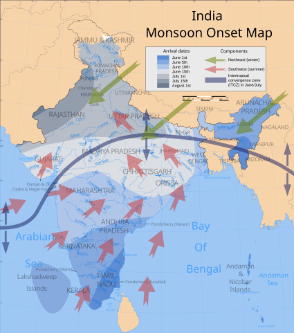
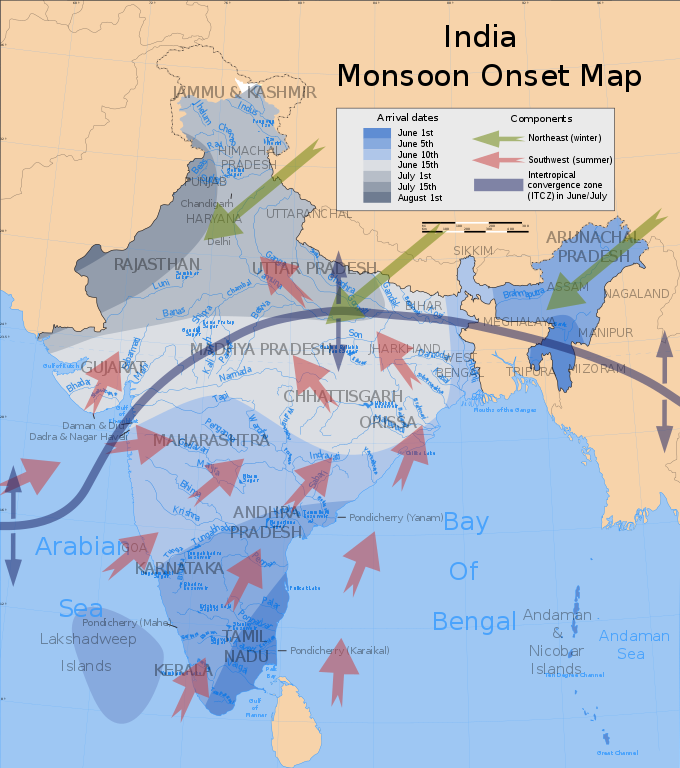
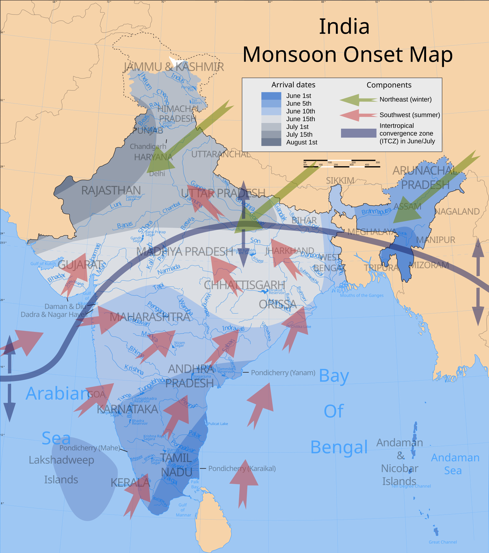
India climatic zone map english version |
|||||||||
| 描寫 |
Map showing average onset (monsoon arrival) dates and wind directions prevalent during India's southwest summer monsoon. |
|||||||||
| 地圖圖例 |
 |
|||||||||
| 日期 | ||||||||||
| 來源 |
自己的作品 Wind currents/ITCZ: Burroughs, WJ (1999), The Climate Revealed, Cambridge University Press, 國際標準書號 0-521-77081-5, p. 138. |
|||||||||
| 創作作者 | ||||||||||
| 授權許可 (重用此檔案) |
我,本作品的著作權持有者,決定用以下授權條款發佈本作品: 此檔案採用創用CC 姓名標示-相同方式分享 3.0 未在地化版本授權條款。
|
|||||||||
| Geotemporal data | ||||||||||
| 描繪日期 | 20世紀下半期和21世紀 | |||||||||
| 空間參照系統 | conic | |||||||||
| 邊框 |
|
|||||||||
| 地理參考 | 如果不合適,請設定「warp_status = skip」為隱藏。 | |||||||||
| Archival data | ||||||||||
| 備註 | Part of WikiProject India Maps | |||||||||
| SVG開發 | ||||||||||
| 其他版本 | 此檔案衍生的作品: India southwest summer monsoon onset map-fr.svg | |||||||||


Notes
Depiction of India's borders
- The territorial boundaries of India are shown as per the actual ground situation in accordance with international practices followed by the United Nations ([2], [3]) and the National Geographic Society ([4], [5])
- This map is meant to be for illustrative purpose only and is not authenticated by official government sources. Please check the list of sources and references used to create the map for a measure of accuracy and verifiability.
- The usage of these maps in India, Pakistan and China are governed by different laws that restrict depictions of boundaries other than what is officially recognized by the state. Please check local laws and modify the map accordingly before use.
Explanation of disputed boundaries


- Boundary of Indian claim : The territory India claims is legally theirs, but the claim is disputed by China and Pakistan.
- Line of Control/Line of Conflict : The de facto administrative boundary recognised by the international community. This UN ceasefire line is considered as a temporary solution to an ongoing conflict since the departure of the British Raj.
Borders of disputed regions
The depicted extent of the former territory of the British Indian Empire, succeeded by Republic of India, may not be accepted by few countries as legal due to ongoing border disputes:
- The northern Himalayan region of the disputed territory Indian-administered Kashmir is claimed by India including (Pakistan-administered Kashmir) and the Chinese-occupied territory of (Ladakh plateau). Since 1972, it is divided between all three countries. See also Line of Control and Line of Actual Control.
- Siachen glacier (shown white) is an actively contested region between India and Pakistan. Since 1984, the region is under Indian control.
- The northeastern territory of Arunachal Pradesh is almost entirely claimed by China as part of its Tibetan territory.
- Minor areas of eastern Kashmir's Ladakh division, Himachal Pradesh and Uttarakhand on the Chinese frontier are claimed by China. These areas are under Indian control.
- A small area of Uttarakhand adjoining the Nepal border along the Sarda river is disputed between the two countries.
For a detailed map of all disputed regions in South Asia, see Image:India disputed areas map.svg
Internal borders
The borders of the state of Meghalaya, Assam and Arunachal Pradesh are shown as interpreted from the North-Eastern Areas (Reorganisation) Act, 1971, but has yet to be verified.
Territorial waters
The limit of the territorial waters of India extends to twelve nautical miles measured from the appropriate baseline. See this for more information.
| 註解 | 該圖片含有註解:在維基媒體共享資源上查看註解 |
檔案歷史
點選日期/時間以檢視該時間的檔案版本。
| 日期/時間 | 縮圖 | 尺寸 | 使用者 | 備註 | |
|---|---|---|---|---|---|
| 目前 | 2007年7月3日 (二) 20:57 | | 1,639 × 1,852(656 KB) | Saravask | {{WikiProject_India_Maps |Title=India climatic zone map english version |Description=Map (corrected) showing average onset (monsoon arrival) dates and wind directions prevalent during India's southwest summer monsoon. |Source=''Onset dates:'' [http://www. |
| 2007年4月24日 (二) 00:01 |  | 1,639 × 1,852(656 KB) | Saravask | {{WikiProject_India_Maps |Title=India climatic zone map english version |Description=Map showing average onset (monsoon arrival) dates and wind directions prevalent during India's southwest summer monsoon. |Source=''Onset dates:'' [http://www.imdmumbai.go | |
| 2007年4月23日 (一) 23:19 |  | 1,639 × 1,852(651 KB) | Saravask | {{WikiProject_India_Maps |Title=India climatic zone map english version |Description=Map showing average onset (monsoon arrival) dates and wind directions prevalent during India's southwest summer monsoon. |Source=''Onset dates:'' [http://www.imdmumbai.go | |
| 2007年4月23日 (一) 22:59 |  | 1,639 × 1,852(651 KB) | Saravask | {{WikiProject_India_Maps |Title=India climatic zone map english version |Description=Map showing average onset (monsoon arrival) dates and wind directions prevalent during India's southwest summer monsoon. |Source=''Onset dates:'' [http://www.imdmumbai.go | |
| 2007年3月26日 (一) 14:00 |  | 1,639 × 1,852(649 KB) | Saravask | {{WikiProject_India_Maps |Title=India climatic zone map english version |Description=Map showing climatic zones in India (Köppen classification) |Source= [http://www.imdmumbai.gov.in/Onset.htm Normal dates of onset of | |
| 2007年3月26日 (一) 13:48 |  | 1,639 × 1,852(649 KB) | Saravask | {{WikiProject_India_Maps |Title=India climatic zone map english version |Description=Map showing climatic zones in India (Köppen classification) |Source= [http://www.imdmumbai.gov.in/Onset.htm Normal dates of onset of | |
| 2007年3月26日 (一) 13:27 |  | 1,639 × 1,852(649 KB) | Saravask | {{WikiProject_India_Maps |Title=India climatic zone map english version |Description=Map showing climatic zones in India (Köppen classification) |Source= [http://cee45q.stanford.edu/2003/briefing_book/images/india_cli |
檔案用途
下列2個頁面有用到此檔案:
全域檔案使用狀況
以下其他 wiki 使用了這個檔案:
- ar.wikipedia.org 的使用狀況
- bh.wikipedia.org 的使用狀況
- ca.wikipedia.org 的使用狀況
- cs.wikipedia.org 的使用狀況
- de.wikipedia.org 的使用狀況
- dty.wikipedia.org 的使用狀況
- el.wikipedia.org 的使用狀況
- en.wikipedia.org 的使用狀況
- en.wikibooks.org 的使用狀況
- eu.wikipedia.org 的使用狀況
- fa.wikipedia.org 的使用狀況
- fr.wikipedia.org 的使用狀況
- hi.wikipedia.org 的使用狀況
- hu.wikipedia.org 的使用狀況
- hy.wikipedia.org 的使用狀況
- incubator.wikimedia.org 的使用狀況
- it.wikipedia.org 的使用狀況
- it.wikibooks.org 的使用狀況
- ja.wikipedia.org 的使用狀況
- kn.wikipedia.org 的使用狀況
- mk.wikipedia.org 的使用狀況
- ml.wikipedia.org 的使用狀況
- ms.wikipedia.org 的使用狀況
- ne.wikipedia.org 的使用狀況
- nl.wikipedia.org 的使用狀況
- nn.wikipedia.org 的使用狀況
- pa.wikipedia.org 的使用狀況
- pnb.wikipedia.org 的使用狀況
檢視此檔案的更多全域使用狀況。