
File:Intracoastal Waterway Louisiana.jpg

預覽大小:800 × 533 像素。 其他解析度:320 × 213 像素 | 640 × 427 像素 | 1,024 × 683 像素 | 1,500 × 1,000 像素。
原始檔案 (1,500 × 1,000 像素,檔案大小:508 KB,MIME 類型:image/jpeg)
| 描述 |
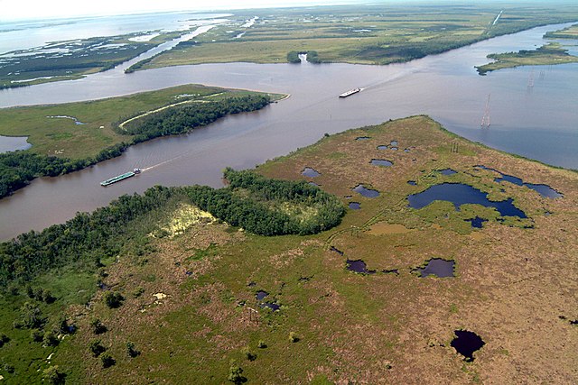
English: Navigation on the Gulf Intracoastal Waterway (GIWW), where it intersects with Bayou Perot in Louisiana, USA. The view in this picture is to the south. The GIWW runs left–right across the picture. The bayou comes in from the left and enters Lake Salvador on the right. The bayou is the boundary between Jefferson Parish in the foreground and Lafourche Parish in the distance beyond the bayou. |
|||
| 日期 | ||||
| 來源 |
U.S. Army Corps of Engineers Digital Visual Library Image page Image description page Digital Visual Library home page |
|||
| 作者 | Lane Lefort, U.S. Army Corps of Engineers | |||
| 授權許可 (重用此檔案) |
|
|||
| 圖中地點 | New Orleans, Louisiana, USA |
| 拍攝地點 | | 位於此地的本圖片與其他圖片: OpenStreetMap |
|---|
檔案歷史
點選日期/時間以檢視該時間的檔案版本。
| 日期/時間 | 縮圖 | 尺寸 | 使用者 | 備註 | |
|---|---|---|---|---|---|
| 目前 | 2007年4月1日 (日) 22:14 | | 1,500 × 1,000(508 KB) | DanMS | {{Information | Description = {{en|Navigation on the Gulf Intracoastal Waterway (GIWW), where it intersects with Bayou Perot, in the vicinity of New Orleans, USA.}} | Source = U.S. Army Corps of Engineers Digital Visual Library<br />[http://ima |
檔案用途
下列頁面有用到此檔案:
全域檔案使用狀況
以下其他 wiki 使用了這個檔案:
- af.wikipedia.org 的使用狀況
- arz.wikipedia.org 的使用狀況
- bn.wikipedia.org 的使用狀況
- cs.wikipedia.org 的使用狀況
- de.wikipedia.org 的使用狀況
- en.wikipedia.org 的使用狀況
- es.wikipedia.org 的使用狀況
- fi.wikipedia.org 的使用狀況
- fr.wikipedia.org 的使用狀況
- gu.wikipedia.org 的使用狀況
- he.wikipedia.org 的使用狀況
- it.wikipedia.org 的使用狀況
- ja.wikipedia.org 的使用狀況
- kn.wikipedia.org 的使用狀況
- pam.wikipedia.org 的使用狀況
- ro.wikipedia.org 的使用狀況
- ru.wikipedia.org 的使用狀況
- ur.wikipedia.org 的使用狀況
- vi.wikipedia.org 的使用狀況