File:Invest 99W 2013-11-01 1930Z IR-color.jpg

頁面內容不支援其他語言。
這個檔案來自維基共享資源
維基百科,自由的百科全書

原始檔案(1,024 × 1,024 像素,檔案大小:307 KB,MIME 類型:image/jpeg


摘要

描述
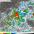
English: The enhanced infrared imagery presents a new-formed tropical disturbance near Kosrae on November 1, 2013, which was designated as “Invest 99W” by the U.S. Navy. The system continued intensifying and ultimately became Typhoon Haiyan, a storm severely devastating the Visayas of the Philippines.
中文(臺灣):此幅2013年11月1日的紅外線強化圖像展示了科斯雷附近剛形成的熱帶擾動,並由美國海軍編為“Invest 99W”。該系統後來持續增強,最終成為颱風海燕,造成菲律賓維薩亞斯群島慘重災情。
日期
來源 http://www.nrlmry.navy.mil/tcdat/tc13/WPAC/31W.HAIYAN/ir/geo/1km/20131101.1930.mtsat1r.x.ir1km.99WINVEST.15kts-NAmb-54N-1617E.100pc.jpg
作者 The U.S. Naval Research Laboratory
拍攝地點5° 30′ 00″ 北, 162° 36′ 00″ 東 Kartographer map based on OpenStreetMap.位於此地的本圖片與其他圖片: OpenStreetMapinfo

授權條款

Public domain
這張圖像是美國海軍軍人或雇員在執行任務時拍攝或繪製的。因本圖像是美國聯邦政府著作物,本圖像位於公有領域

說明

添加單行說明來描述出檔案所代表的內容

在此檔案描寫的項目

描繪內容

5°30'N, 162°36'E

檔案歷史

點選日期/時間以檢視該時間的檔案版本。

日期/時間縮⁠圖尺寸使用者備⁠註
目前2014年6月9日 (一) 12:25於 2014年6月9日 (一) 12:25 版本的縮圖1,024 × 1,024(307 KB)MeowUser created page with UploadWizard

下列頁面有用到此檔案: