
File:Kerch Strait Landsat.jpg

預覽大小:800 × 600 像素。 其他解析度:320 × 240 像素 | 640 × 480 像素 | 1,024 × 768 像素 | 1,280 × 960 像素 | 1,600 × 1,200 像素。
原始檔案 (1,600 × 1,200 像素,檔案大小:294 KB,MIME 類型:image/jpeg)
摘要
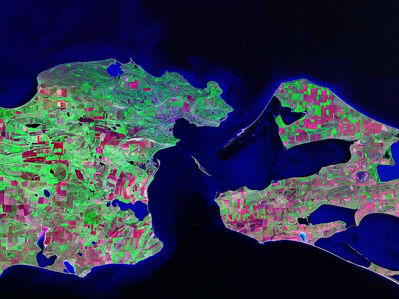
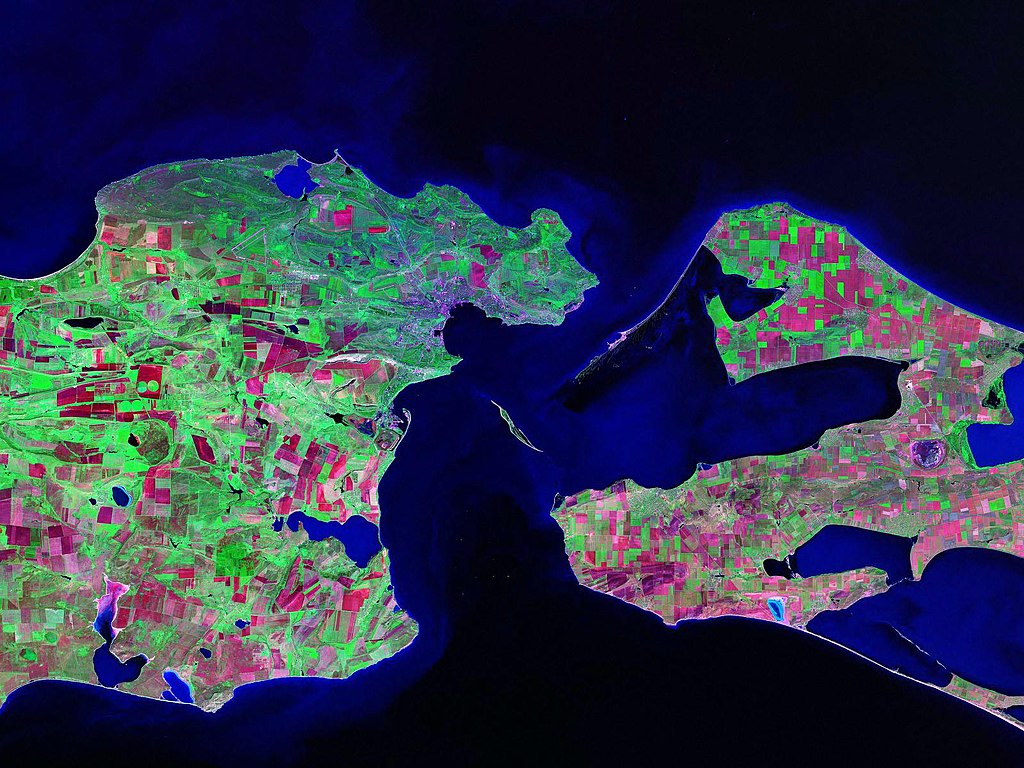
Landsat satellite (false color) photo of Kerch Strait between the Sea of Azov and the Black Sea.
Source: zulu.ssc.nasa.gov
| 拍攝地點 | | 位於此地的本圖片與其他圖片: OpenStreetMap |
|---|
授權條款
| 本作品由NASA創作,屬於公有領域。根據NASA的版權政策:“NASA的創作除非另有聲明否則不受版權保護。”(參見:Template:PD-USGov/zh,NASA版權政策或JPL圖像使用政策) | ||
 |
警告:
|
檔案歷史
點選日期/時間以檢視該時間的檔案版本。
| 日期/時間 | 縮圖 | 尺寸 | 使用者 | 備註 | |
|---|---|---|---|---|---|
| 目前 | 2006年10月17日 (二) 13:52 | | 1,600 × 1,200(294 KB) | Balcer~commonswiki | Landsat satellite (false color) photo of Kerch Strait between the Sea of Azov and the Black Sea. Source:zulu.ssc.nasa.gov Category:Black Sea Category:Satellite pictures of Russia Category:Satellite pictures of Ukraine |
檔案用途
全域檔案使用狀況
以下其他 wiki 使用了這個檔案:
- be.wikipedia.org 的使用狀況
- ca.wikipedia.org 的使用狀況
- ceb.wikipedia.org 的使用狀況
- crh.wikipedia.org 的使用狀況
- cs.wikipedia.org 的使用狀況
- de.wikipedia.org 的使用狀況
- el.wikipedia.org 的使用狀況
- en.wikipedia.org 的使用狀況
- eo.wikipedia.org 的使用狀況
- es.wikipedia.org 的使用狀況
- fa.wikipedia.org 的使用狀況
- fi.wikipedia.org 的使用狀況
- fr.wikipedia.org 的使用狀況
- hr.wikipedia.org 的使用狀況
- hy.wikipedia.org 的使用狀況
- it.wikipedia.org 的使用狀況
- ko.wikipedia.org 的使用狀況
- nn.wikipedia.org 的使用狀況
- no.wikipedia.org 的使用狀況
- pl.wikipedia.org 的使用狀況
- pnb.wikipedia.org 的使用狀況
- pt.wikipedia.org 的使用狀況
- ru.wikipedia.org 的使用狀況
- sk.wikipedia.org 的使用狀況
- sv.wikipedia.org 的使用狀況
- tr.wikipedia.org 的使用狀況
- ug.wikipedia.org 的使用狀況
- uk.wikipedia.org 的使用狀況
- Конфлікт щодо острова Тузла
- Керченська протока
- Користувач:Alex Blokha/Події в Вікіпедії/6 жовтня
- Користувач:Alex Blokha/Події в Вікіпедії/23 жовтня
- Користувач:Alex Blokha/Події в Вікіпедії/2 грудня
- Користувач:Alex Blokha/Події в Вікіпедії/7 січня
- Користувач:Alex Blokha/Події в Вікіпедії/19 лютого
- Державний кордон України
- Користувач:Alex Blokha/Дні згадані в Вікіпедії/Україна/6 жовтня
- Користувач:Alex Blokha/Дні згадані в Вікіпедії/Україна/22 жовтня
- Користувач:Alex Blokha/Дні згадані в Вікіпедії/Україна/2 грудня
- Користувач:Alex Blokha/Дні згадані в Вікіпедії/Україна/7 січня
檢視此檔案的更多全域使用狀況。