
File:Map of Shootings at Kent State University in 1970.jpg
預覽大小:770 × 600 像素。 其他解析度:308 × 240 像素 | 616 × 480 像素 | 986 × 768 像素 | 1,200 × 935 像素。
原始檔案 (1,200 × 935 像素,檔案大小:364 KB,MIME 類型:image/jpeg)
摘要
| 描述 |
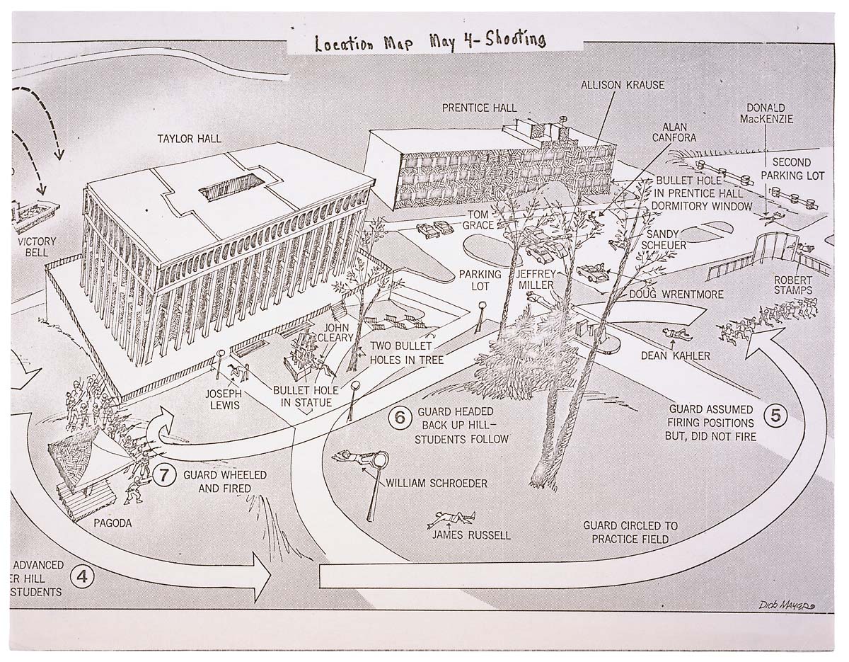
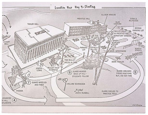
English: This is a printed map detailing the locations of structures, troop movements, bullet hole locations, and locations of casualties at the Kent State shooting of May 4, 1970. |
|||
| 日期 | 5/04/1970 | |||
| 來源 | https://catalog.archives.gov/id/596837 | |||
| 作者 | President (1969-1974 : Nixon). President's Commission on Campus Unrest. | |||
| 授權許可 (重用此檔案) |
|
授權條款
此作品在美國屬於公有領域,因為其是由美國政府的官員或僱員,基於其個人公務目的製作的作品,參考美國法典第17篇第1章第105條。
注意︰本模板僅適用於美國聯邦政府的原創作品,不適用於任何美國州、屬地、聯邦個體、縣、市或任何次級政府的作品。本模板也不適用於1978年以後由美國郵政署出版的郵票圖案(參看美國版權局實踐綱領第313.6(C)(1)條)。也不適用於部分美國硬幣;參看美國鑄幣局使用條款。 |
 | |
| 此作品無已知的著作權限制,亦不受所有相關和鄰接的權利限制。 | ||
檔案歷史
點選日期/時間以檢視該時間的檔案版本。
| 日期/時間 | 縮圖 | 尺寸 | 使用者 | 備註 | |
|---|---|---|---|---|---|
| 目前 | 2008年6月9日 (一) 01:26 | | 1,200 × 935(364 KB) | Goldfishbutt | {{Information |Description={{en|1=This is a printed map detailing the locations of structures, troop movements, bullet hole locations, and locations of casualties at the Kent State shooting of May 4, 1970.}} |Source=http://arcweb.archives.gov/arc/arch_res |
檔案用途
下列頁面有用到此檔案:
全域檔案使用狀況
以下其他 wiki 使用了這個檔案:
- af.wikipedia.org 的使用狀況
- de.wikipedia.org 的使用狀況
- en.wikipedia.org 的使用狀況
- en.wikibooks.org 的使用狀況
- en.wikiquote.org 的使用狀況
- fr.wikipedia.org 的使用狀況
- he.wikipedia.org 的使用狀況
- it.wikipedia.org 的使用狀況
- ja.wikipedia.org 的使用狀況
- nl.wikipedia.org 的使用狀況
- no.wikipedia.org 的使用狀況
- sv.wikipedia.org 的使用狀況