
File:Map of traditional provinces of Libye-en.svg

此 SVG 檔案的 PNG 預覽的大小:625 × 599 像素。 其他解析度:250 × 240 像素 | 501 × 480 像素 | 801 × 768 像素 | 1,068 × 1,024 像素 | 2,136 × 2,048 像素 | 969 × 929 像素。
原始檔案 (SVG 檔案,表面大小:969 × 929 像素,檔案大小:106 KB)
| 描述 |
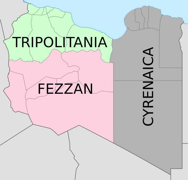
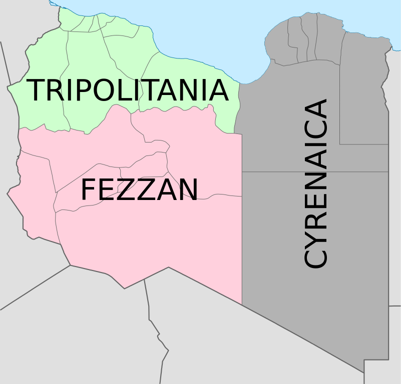
Deutsch: Historische provinzen (Governorates) Libyens English: Map of the three Governorates of Libya based on the borders of today's governorates. After independence in 1951, until 1963, Libya was divided into three governorates (muhafazat): Cyrenaica, Tripolitania, and Fezzan. The eastern border between Tripolitania and Fezzan was before 1969 slightly different: the northern part of Al Jufrah District in today's Fezzan belonged to Tripolitania, see here File:Ottoman Provinces Of Present day Libyapng.png. Español: Mapa de las tres governorates de Libia: Tripolitania, Fezzan, y Cirenaica. Français : Carte en anglais des trois provinces historiques (gouvernorats) de la Libye contemporaine. |
| 日期 | (UTC) |
| 來源 | |
| 作者 |
|
| 其他版本 |
|


| 這是一張修飾過的圖片,即本圖片是用軟體修改過後的版本,修改的方式或內容有:translation in english。原版圖片來源:Map of traditionnal provinces of Libye fr.svg。修改者:Bourrichon。
|
我,本作品的著作權持有者,決定用以下授權條款發佈本作品:
此檔案採用創用CC 姓名標示 3.0 未在地化版本授權條款。
- 您可以自由:
- 分享 – 複製、發佈和傳播本作品
- 重新修改 – 創作演繹作品
- 惟需遵照下列條件:
- 姓名標示 – 您必須指名出正確的製作者,和提供授權條款的連結,以及表示是否有對內容上做出變更。您可以用任何合理的方式來行動,但不得以任何方式表明授權條款是對您許可或是由您所使用。

|
已授權您依據自由軟體基金會發行的無固定段落、封面文字和封底文字GNU自由文件授權條款1.2版或任意後續版本,對本檔進行複製、傳播和/或修改。該協議的副本列在GNU自由文件授權條款中。 |
您可以選擇您需要的授權條款。
原始上傳日誌
This image is a derivative work of the following images:
- File:Map_of_traditionnal_provinces_of_Libye_fr.svg licensed with Cc-by-3.0, GFDL
- 2011-02-25T14:34:29Z Пакко 969x929 (120204 Bytes) upg
- 2011-02-25T13:46:48Z Xfigpower 970x931 (162661 Bytes) {{Information |Description={{fr|les trois provinces mappées sur la arte actuelle de la LibyeLes couleurs sont celles symbolisées par le drapeau}} |Source=*[[:File:Libya_location_map.svg|]] |Date=2011-02-25 13:29 (UTC) |Auth
Uploaded with derivativeFX
檔案歷史
點選日期/時間以檢視該時間的檔案版本。
| 日期/時間 | 縮圖 | 尺寸 | 使用者 | 備註 | |
|---|---|---|---|---|---|
| 目前 | 2021年8月24日 (二) 08:36 | | 969 × 929(106 KB) | أحمد الغرباوي | File uploaded using svgtranslate tool (https://svgtranslate.toolforge.org/). Added translation for ar. |
| 2020年12月6日 (日) 15:44 |  | 969 × 929(104 KB) | ידידיה צ' צבאן | File uploaded using svgtranslate tool (https://svgtranslate.toolforge.org/). Added translation for he. | |
| 2011年10月12日 (三) 03:46 |  | 969 × 929(104 KB) | Spesh531 | updated to current internal boundaries | |
| 2011年8月30日 (二) 12:50 |  | 969 × 929(147 KB) | Orange Tuesday | see http://www.crwflags.com/fotw/flags/ly_1951.html for source on traditional colours | |
| 2011年8月30日 (二) 01:40 |  | 969 × 929(124 KB) | Hellerick | Found no information on "traditional association" | |
| 2011年6月13日 (一) 20:24 |  | 969 × 929(147 KB) | Kmusser | shift colors to match traditional association | |
| 2011年4月29日 (五) 11:04 |  | 969 × 929(125 KB) | Hellerick | Neutral colors; + foreign nations borders | |
| 2011年3月16日 (三) 13:02 |  | 969 × 929(121 KB) | Bourrichon | typo | |
| 2011年3月16日 (三) 13:01 |  | 969 × 929(121 KB) | Bourrichon | +bug typo | |
| 2011年3月16日 (三) 12:58 |  | 969 × 929(112 KB) | Bourrichon | {{Information |Description={{de|Historische provinzen (Governorates) Libyens}} {{en| Map of the three '''{{w|Governorates of Libya}}'''. After independence in 1951, until 1963, Libya was divided into three governorates (''{{w|muhafazat}}''): '''{{w|Cyrena |
檔案用途
沒有使用此檔案的頁面。
全域檔案使用狀況
以下其他 wiki 使用了這個檔案:
- ast.wikipedia.org 的使用狀況
- az.wikipedia.org 的使用狀況
- bs.wikipedia.org 的使用狀況
- ca.wikipedia.org 的使用狀況
- cs.wikipedia.org 的使用狀況
- diq.wikipedia.org 的使用狀況
- en.wikipedia.org 的使用狀況
- History of Libya
- Libya
- Geography of Libya
- Demographics of Libya
- Politics of Libya
- Economy of Libya
- Mass media in Libya
- Transport in Libya
- Armed Forces of the Libyan Arab Jamahiriya
- Foreign relations of Libya under Muammar Gaddafi
- Fatimid Caliphate
- Idris of Libya
- List of cities in Libya
- Operation Sonnenblume
- Libyan dinar
- List of heads of state of Libya
- Districts of Libya
- Great Man-Made River
- List of colonial governors of Italian Cyrenaica
- List of heads of government of Libya
- Music of Libya
- Elections in Libya
- Karamanli dynasty
- Ahmed Karamanli
- Culture of Libya
- Central Bank of Libya
- Public Scout and Girl Guide Movement
- General People's Congress (Libya)
- Human rights in Libya
- Subdivisions of Libya
- Provinces of Libya
- Islamic Tripolitania and Cyrenaica
- Ottoman Tripolitania
- Italian colonization of Libya
- History of Libya under Muammar Gaddafi
- Chadian–Libyan War
- Ancient Libya
- Template:Libya topics
- Media of Libya
- Kingdom of Libya
- Minister of Foreign Affairs (Libya)
檢視此檔案的更多全域使用狀況。