
File:MiG Alley Map.JPG
無更高解析度可提供。
MiG_Alley_Map.JPG (348 × 375 像素,檔案大小:52 KB,MIME 類型:image/jpeg)
摘要

|
File:MiG Alley Map (en).svg是本檔案的向量版本。 如果品質不低,就應該優先使用該檔案,而非JPG檔案。
File:MiG Alley Map.JPG → File:MiG Alley Map (en).svg
更多資訊請參閱Help:SVG/zh。 |
.svg) |
| 描述 |
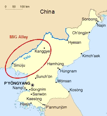
Deutsch: Das Gebiet an der chinesisch-nordkoreanischen Grenze, das während des Koreakrieges (1950-53) als "MiG Alley" berühmt wurde.
English: The area called "MiG Alley" during the Korean War (1950-53) on the Chinese-North Korean border. |
| 日期 | 01.06.2006 |
| 來源 | 自己的作品 based on CIA Factbook map on North Korea |
| 作者 | Triggerhappy |
| 其他版本 |
Chinese: Russian: Russian: |
授權條款
| 我,此作品的版權所有人,釋出此作品至公共領域。此授權條款在全世界均適用。 這可能在某些國家不合法,如果是的話: 我授予任何人有權利使用此作品於任何用途,除受法律約束外,不受任何限制。 |
檔案歷史
點選日期/時間以檢視該時間的檔案版本。
| 日期/時間 | 縮圖 | 尺寸 | 使用者 | 備註 | |
|---|---|---|---|---|---|
| 目前 | 2012年1月27日 (五) 20:09 | | 348 × 375(52 KB) | Hohum | Cleanup |
| 2006年6月1日 (四) 17:27 |  | 348 × 375(21 KB) | Triggerhappy | {{Information |Description=*'''de:''' Das Gebiet an der chinesisch-nordkoreanischen Grenze, das während des Koreakrieges (1950-53) als "MiG Alley" berühmt wurde. *'''en:''' The area called "MiG Alley" during the Korean War (1950-53) on the chinese-north |
檔案用途
下列頁面有用到此檔案: