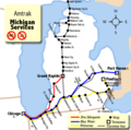
File:Michigan Services map.png
外觀
Michigan_Services_map.png (540 × 535 像素,檔案大小:51 KB,MIME 類型:image/png)
檔案歷史
點選日期/時間以檢視該時間的檔案版本。
| 日期/時間 | 縮圖 | 尺寸 | 使用者 | 備註 | |
|---|---|---|---|---|---|
| 目前 | 2007年4月19日 (四) 15:22 |  | 540 × 535(51 KB) | Shadowlink1014~commonswiki | |
| 2007年4月19日 (四) 06:17 |  | 540 × 535(51 KB) | Shadowlink1014~commonswiki | ||
| 2007年4月19日 (四) 04:35 |  | 540 × 535(42 KB) | Shadowlink1014~commonswiki | ||
| 2007年4月18日 (三) 18:25 |  | 540 × 535(42 KB) | Shadowlink1014~commonswiki | {{Information |Description=Map of Amtrak Michigan Services -- it consists of three lines, the ''Pere Marquette'', the ''Blue Water'', and the ''Wolverine''. The map in the background is from Map_of_USA_without_state_names.svg - which is licensed under the |
檔案用途
全域檔案使用狀況
以下其他 wiki 使用了這個檔案:
- en.wikipedia.org 的使用狀況
- en.wikinews.org 的使用狀況
- es.wikinews.org 的使用狀況
- fi.wikipedia.org 的使用狀況
- he.wikinews.org 的使用狀況
- ja.wikipedia.org 的使用狀況
- ko.wikipedia.org 的使用狀況
- www.wikidata.org 的使用狀況


