
File:Nelson Mandela Bay 2011 population density map.svg

此 SVG 檔案的 PNG 預覽的大小:666 × 600 像素。 其他解析度:267 × 240 像素 | 533 × 480 像素 | 853 × 768 像素 | 1,137 × 1,024 像素 | 2,275 × 2,048 像素 | 913 × 822 像素。
原始檔案 (SVG 檔案,表面大小:913 × 822 像素,檔案大小:157 KB)
摘要
| 描述 |
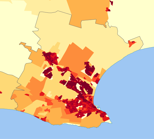
English: Population density map of the Nelson Mandela Bay Metro, Eastern Cape, South Africa, from the 2011 Census, at the "Small Area" level.
<1 inhabitant/km²
1–3 inhabitants/km²
3–10 inhabitants/km²
10–30 inhabitants/km²
30–100 inhabitants/km²
100–300 inhabitants/km²
300–1000 inhabitants/km²
1000–3000 inhabitants/km²
>3000 inhabitants/km² |
| 日期 | |
| 來源 | Statistics South Africa's Census 2011 is the source of the basic population data. The map results from my own processing of the data. |
| 作者 | Htonl |
| 授權許可 (重用此檔案) |
http://beta2.statssa.gov.za/?page_id=425 |
授權條款
The following license applies to the population data on which the map is based:

|
本檔案的著作權持有者,Statistics South Africa (States SA),在註明所有人姓名的前提下,允許任何人使用本檔案於任何用途。包含再散布、衍生作品、商業用途及其他用途。 |
姓名標示:
Statistics South Africa (States SA)
|
The following tag applies to the map itself:
| 我,此作品的版權所有人,釋出此作品至公共領域。此授權條款在全世界均適用。 這可能在某些國家不合法,如果是的話: 我授予任何人有權利使用此作品於任何用途,除受法律約束外,不受任何限制。 |
檔案歷史
點選日期/時間以檢視該時間的檔案版本。
| 日期/時間 | 縮圖 | 尺寸 | 使用者 | 備註 | |
|---|---|---|---|---|---|
| 目前 | 2013年10月13日 (日) 14:30 | | 913 × 822(157 KB) | Htonl | == {{int:filedesc}} == {{Information |Description={{en|1=Population density map of the Nelson Mandela Bay Metro, Eastern Cape, South Africa, from the 2011 Census, at the "Small Area" level. {{legend|#ffffcc|<1 inhabitant/km²}} {{legend|#ffeda0|1–... |
檔案用途
下列頁面有用到此檔案:
全域檔案使用狀況
以下其他 wiki 使用了這個檔案:
- en.wikipedia.org 的使用狀況
- ja.wikipedia.org 的使用狀況
- vi.wikipedia.org 的使用狀況