
File:PIA02820.jpg

預覽大小:800 × 554 像素。 其他解析度:320 × 222 像素 | 640 × 443 像素 | 1,024 × 709 像素 | 1,280 × 886 像素 | 2,560 × 1,772 像素 | 4,000 × 2,769 像素。
原始檔案 (4,000 × 2,769 像素,檔案大小:1.06 MB,MIME 類型:image/jpeg)
摘要
| 描述 |
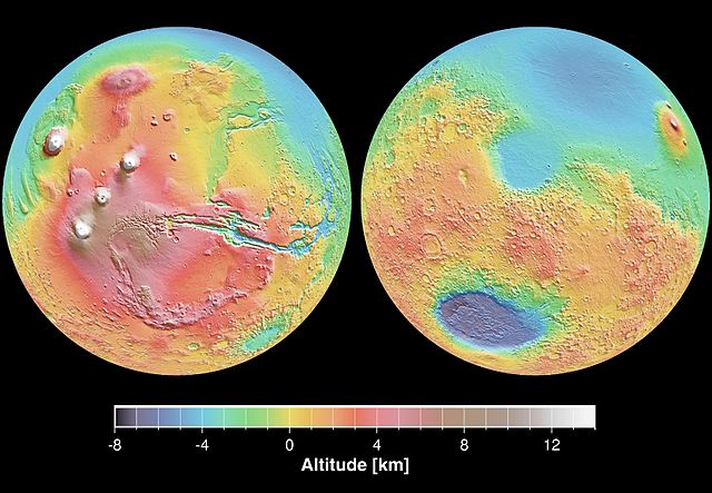
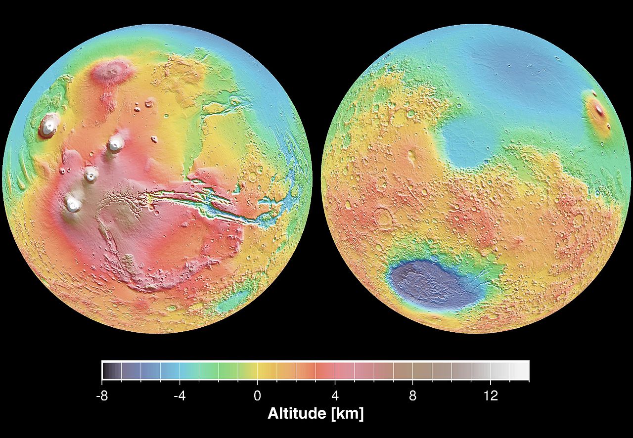
English: These maps are global false-color topographic views of Mars at different orientations from the Mars Orbiter Laser Altimeter (MOLA). The maps are orthographic projections that contain over 200,000,000 points and about 5,000,000 altimetric crossovers. The spatial resolution is about 15 kilometers at the equator and less at higher latitudes. The vertical accuracy is less than 5 meters. The right hand image view features the Hellas impact basin (in purple, with red annulus of high standing material). The left hand features the Tharsis topographic rise (in red and white). Note also the subtle textures associated with resurfacing of the northern hemisphere lowlands in the vicinity of the Utopia impact basin. This data was compiled by the Mars Orbiter Laser Altimeter (MOLA) Team, led by David Smith at the Goddard Space Flight Center in Greenbelt, MD.
Español: Levantamento topográfico realizado pela sonda norte-americana Mars Global Surveyor |
| 日期 | |
| 來源 | http://photojournal.jpl.nasa.gov/catalog/PIA02820 |
| 作者 | NASA/JPL |
| 此標籤不表示文件的著作權狀態。任何文件在附有此標籤的同時還需要一個有效的著作權標籤。請參閱許可協議說明頁面以了解更多資訊。 其他語言:
|
授權條款
| 本作品由NASA創作,屬於公有領域。根據NASA的版權政策:“NASA的創作除非另有聲明否則不受版權保護。”(參見:Template:PD-USGov/zh,NASA版權政策或JPL圖像使用政策) | ||
 |
警告:
|
檔案歷史
點選日期/時間以檢視該時間的檔案版本。
| 日期/時間 | 縮圖 | 尺寸 | 使用者 | 備註 | |
|---|---|---|---|---|---|
| 目前 | 2005年12月29日 (四) 19:23 | | 4,000 × 2,769(1.06 MB) | Severino666~commonswiki | Levantamento topográfico realizado pela sonda norte-americana Mars Global Surveyor Category:Mars |
檔案用途
下列頁面有用到此檔案:
全域檔案使用狀況
以下其他 wiki 使用了這個檔案:
- ca.wikipedia.org 的使用狀況
- cs.wikipedia.org 的使用狀況
- en.wikipedia.org 的使用狀況
- en.wikibooks.org 的使用狀況
- en.wikiversity.org 的使用狀況
- es.wikipedia.org 的使用狀況
- fi.wikipedia.org 的使用狀況
- fr.wikipedia.org 的使用狀況
- it.wikipedia.org 的使用狀況
- ja.wikipedia.org 的使用狀況
- mk.wikipedia.org 的使用狀況
- ml.wikipedia.org 的使用狀況
- nap.wikipedia.org 的使用狀況
- no.wikipedia.org 的使用狀況
- olo.wikipedia.org 的使用狀況
- pt.wikipedia.org 的使用狀況
- pt.wikibooks.org 的使用狀況
- ro.wikipedia.org 的使用狀況
- ru.wikipedia.org 的使用狀況
- sk.wikipedia.org 的使用狀況
- sv.wikipedia.org 的使用狀況