
File:Santiam Pass.jpg

原始檔案 (2,272 × 1,514 像素,檔案大小:1.86 MB,MIME 類型:image/jpeg)
| 描述 |
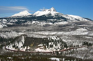
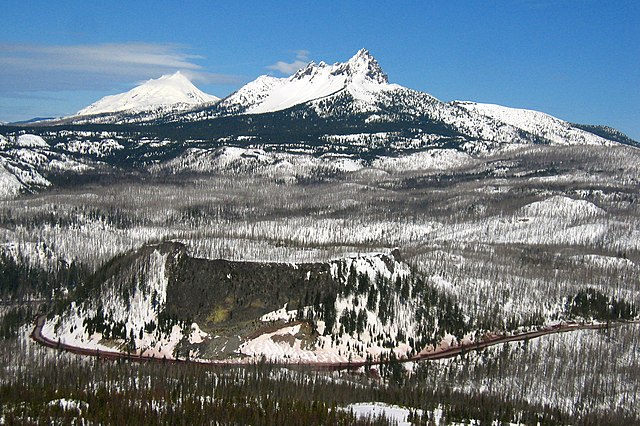
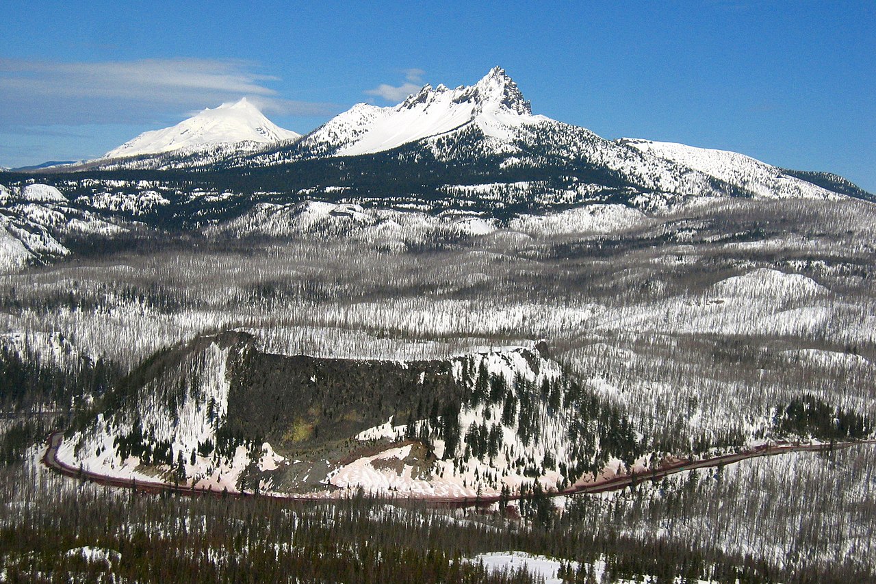
This is the majestic Santiam Pass, elevated at. 4817 ft above sea level in central Oregon Cascades. It is located about 18 mi (29 km) northwest of Sisters, between volcanic peaks of Three Fingered Jack to the north and Mount Washington to the south. U.S. Highway 20 connects eastern Oregon with the valley of the Santiam River on the west via Santiam Pass. One of the 19 or 20 lakes by the name of Lost Lake is located beside the highway just west of Santiam Pass. While the pass was known by native peoples, the first recorded crossing of the pass was in April 1859 by an expedition searching for a cattle trail over the Cascade Range from the Willamette Valley to Central Oregon. This expedition was led by Andrew Wiley, who reportedly climbed a tall tree on a mountain near Lost Prairie to help determine the route. Lost Prairie is located along Hackleman Creek between Fish Lake and Tombstone Prairie. Wiley later helped establish the Santiam Wagon Road. The prominent glaciated peak on the photo is the Three Fingered Jack, a Pleistocene volcano elevated 7,841 foot (2,390 meter), deeply glaciated and consists mainly of basaltic andesite lava. Mount Jefferson can also be seen from its left. The typical tuya volcano Hogg Rock, which is clearly visible from the photo below the Three Fingered Jack where US 20 Highway wraps in a nearly 180-degree curve below cliffs on the south and west sides, is only about 2 miles (3 km) north of Hayrick Butte, a somewhat larger tuya of similar age and composition. A tuya is a type of subglacial volcano, formed when lava erupts underneath an overlying glacier or ice sheet and then melts through to the surface and pools, producing the flat plateau on top with near-vertical walls along the ice-contact margin as the lava cools and hardens. Unlike most tuyas which have steep cliffs on all sides, Hogg Rock has a break in its cliffs on the east side, with a moderate slope which leads down to a small road and gravel pit. Santiam Pass was also the intended route over the Cascades for the Oregon Pacific Railroad, an early transcontinental railroad project led by Col. T. Egenton Hogg for whom Hogg Rock is named. Although the working line never extended east of Santiam Pass, the pass is today the eastern terminus of the Oregon Pacific Railroad Linear Historic District, which is listed on the US National Register of Historic Places. Taken from Hoodoo Ski Bowl summit. |
| 日期 | |
| 來源 | santiam pass |
| 作者 | Shaun Che from Oregon, US |
| 目標地點 | | 位於此地的本圖片與其他圖片: OpenStreetMap |
|---|
授權條款
- 您可以自由:
- 分享 – 複製、發佈和傳播本作品
- 重新修改 – 創作演繹作品
- 惟需遵照下列條件:
- 姓名標示 – 您必須指名出正確的製作者,和提供授權條款的連結,以及表示是否有對內容上做出變更。您可以用任何合理的方式來行動,但不得以任何方式表明授權條款是對您許可或是由您所使用。
| This image, originally posted to Flickr, was reviewed on March 14, 2009 by the administrator or reviewer File Upload Bot (Magnus Manske), who confirmed that it was available on Flickr under the stated license on that date. |
| 註解 | 該圖片含有註解:在維基媒體共享資源上查看註解 |
檔案歷史
點選日期/時間以檢視該時間的檔案版本。
| 日期/時間 | 縮圖 | 尺寸 | 使用者 | 備註 | |
|---|---|---|---|---|---|
| 目前 | 2009年3月14日 (六) 06:29 | | 2,272 × 1,514(1.86 MB) | File Upload Bot (Magnus Manske) | {{Information |Description= This is the majestic [http://en.wikipedia.org/wiki/Santiam_Pass Santiam Pass], elevated at. 4817 ft above sea level in central Oregon Cascades. It is located about 18 mi (29 km) northwest of Sisters, between volcanic peaks of |
檔案用途
下列2個頁面有用到此檔案:
全域檔案使用狀況
以下其他 wiki 使用了這個檔案:
- en.wikipedia.org 的使用狀況
- es.wikipedia.org 的使用狀況
- fr.wikipedia.org 的使用狀況
- id.wikipedia.org 的使用狀況
- it.wikipedia.org 的使用狀況
- pt.wikipedia.org 的使用狀況
- uk.wikipedia.org 的使用狀況
- www.wikidata.org 的使用狀況