
File:SatavahanaMap.jpg

預覽大小:467 × 599 像素。 其他解析度:187 × 240 像素 | 374 × 480 像素 | 599 × 768 像素 | 1,123 × 1,440 像素。
原始檔案 (1,123 × 1,440 像素,檔案大小:327 KB,MIME 類型:image/jpeg)

|
This map has been uploaded by Electionworld from en.wikipedia.org to enable the |

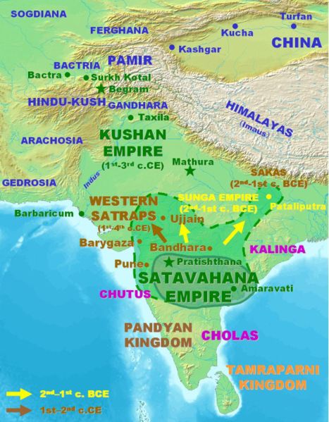
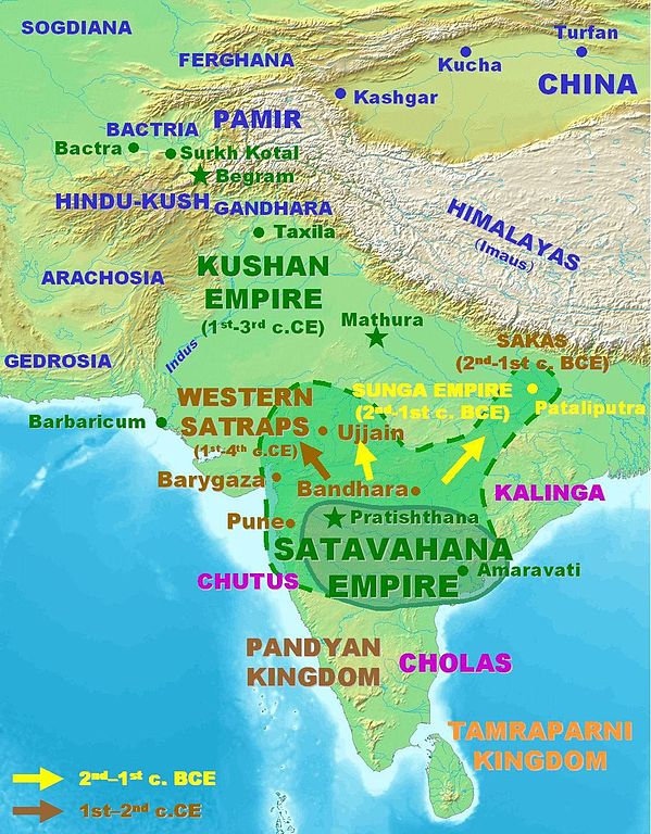
Approximate extent of the Satavahana Empire.
Personal map, 2005. Released in the Public Domain.
| 此作品已由其作者,PHG,釋出至公有領域。此授權條款在全世界均適用。 這可能在某些國家不合法,如果是的話: |
檔案歷史
點選日期/時間以檢視該時間的檔案版本。
| 日期/時間 | 縮圖 | 尺寸 | 使用者 | 備註 | |
|---|---|---|---|---|---|
| 目前 | 2007年3月18日 (日) 14:09 | | 1,123 × 1,440(327 KB) | World Imaging | Better map, personal creation. |
| 2006年12月13日 (三) 23:21 |  | 395 × 432(29 KB) | Electionworld | {{ew|en|PHG}} {{POV-map}} Approximate extent of the Satavahana Empire. Personal map, 2005. Released in the Public Domain. {{pd}} |
檔案用途
全域檔案使用狀況
以下其他 wiki 使用了這個檔案:
- ba.wikipedia.org 的使用狀況
- bn.wikipedia.org 的使用狀況
- ca.wikipedia.org 的使用狀況
- cs.wikipedia.org 的使用狀況
- cv.wikipedia.org 的使用狀況
- de.wikipedia.org 的使用狀況
- en.wikipedia.org 的使用狀況
- es.wikipedia.org 的使用狀況
- eu.wikipedia.org 的使用狀況
- fa.wikipedia.org 的使用狀況
- fi.wikipedia.org 的使用狀況
- fr.wikipedia.org 的使用狀況
- hi.wikipedia.org 的使用狀況
- hy.wikipedia.org 的使用狀況
- id.wikipedia.org 的使用狀況
- id.wikibooks.org 的使用狀況
- it.wikipedia.org 的使用狀況
- kn.wikipedia.org 的使用狀況
- ko.wikipedia.org 的使用狀況
- lt.wikipedia.org 的使用狀況
- mr.wikipedia.org 的使用狀況
- nl.wikipedia.org 的使用狀況
- pnb.wikipedia.org 的使用狀況
- ru.wikipedia.org 的使用狀況
- sa.wikipedia.org 的使用狀況
- sh.wikipedia.org 的使用狀況
- si.wikipedia.org 的使用狀況
- sq.wikipedia.org 的使用狀況
- sr.wikipedia.org 的使用狀況
- te.wikipedia.org 的使用狀況
- th.wikipedia.org 的使用狀況
- tl.wikipedia.org 的使用狀況
- tt.wikipedia.org 的使用狀況
- uk.wikipedia.org 的使用狀況
- ur.wikipedia.org 的使用狀況
檢視此檔案的更多全域使用狀況。