
File:Suhongtu site - Sinornithomimus quarry.png

預覽大小:800 × 529 像素。 其他解析度:320 × 211 像素 | 640 × 423 像素 | 1,147 × 758 像素。
原始檔案 (1,147 × 758 像素,檔案大小:496 KB,MIME 類型:image/png)
摘要
| 描述 |
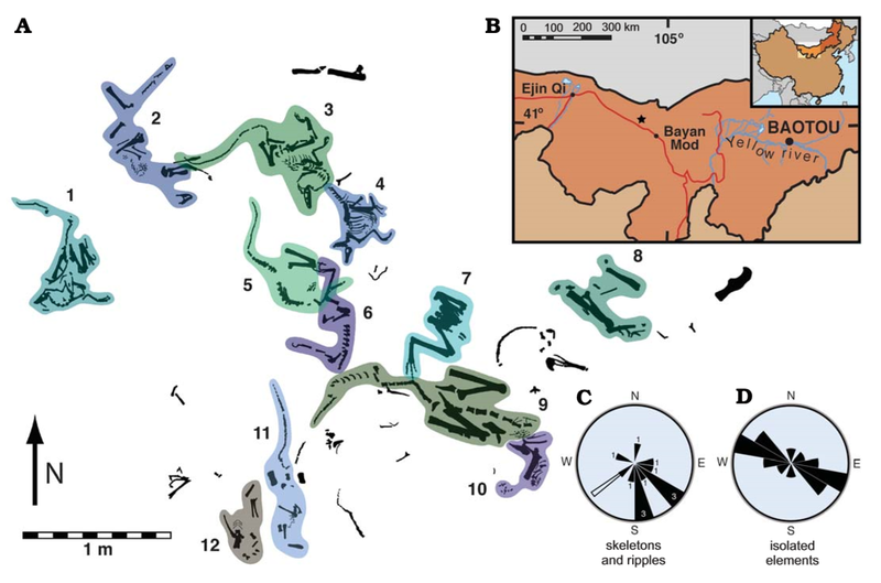
English: Suhongtu site, partial quarry map, locality map, and orientation data. A. Map of the central and northern portions of site showing the position of 12 of 13 skeletons. Skeletons 3 and 4 enlarged in Fig. 3. B. Fossil locality (41°17’ 10”N, 103°52’38”E) located 90 km northwest of Bayan Mod, InnerMongolia, China. C. Rose−diagram showing trends for skeletons (black, numbers denote skeleton count) and ripples (white). D. Mirror rose−diagram of elongated, isolated elements (n=13). Trends of skeletons have a strong, non−random (p<0.002) alignment to southeast. Flow direction of ripples is roughly perpendicular to that of elongate elements. |
| 日期 | |
| 來源 | (2008). "Mud-Trapped Herd Captures Evidence of Distinctive Dinosaur Sociality". Acta Palaeontologica Polonica 53 (4): 567–578. DOI:10.4202/app.2008.0402. 國際標準期刊號 0567-7920. |
| 作者 | David J. Varricchio, Paul C. Sereno, Zhao Xi-jin, Tan Lin Jeffrey A. Wilson & Gabrielle H. Lyon |
授權條款
此檔案採用創用CC 姓名標示 4.0 國際授權條款。
- 您可以自由:
- 分享 – 複製、發佈和傳播本作品
- 重新修改 – 創作演繹作品
- 惟需遵照下列條件:
- 姓名標示 – 您必須指名出正確的製作者,和提供授權條款的連結,以及表示是否有對內容上做出變更。您可以用任何合理的方式來行動,但不得以任何方式表明授權條款是對您許可或是由您所使用。
檔案歷史
點選日期/時間以檢視該時間的檔案版本。
| 日期/時間 | 縮圖 | 尺寸 | 使用者 | 備註 | |
|---|---|---|---|---|---|
| 目前 | 2020年8月21日 (五) 05:28 | | 1,147 × 758(496 KB) | PaleoNeolitic | {{Information |description ={{en|1=Suhongtu site, partial quarry map, locality map, and orientation data. '''A'''. Map of the central and northern portions of site showing the position of 12 of 13 skeletons. Skeletons 3 and 4 enlarged in Fig. 3. '''B'''. Fossil locality (41°17’ 10”N, 103°52’38”E) located 90 km northwest of Bayan Mod, InnerMongolia, China. '''C'''. Rose−diagram showing trends for skeletons (black, numbers denote skeleton count) and ripples (white). '''D'''. Mirror rose−diagr... |
檔案用途
下列頁面有用到此檔案:
全域檔案使用狀況
以下其他 wiki 使用了這個檔案:
- ar.wikipedia.org 的使用狀況
- ca.wikipedia.org 的使用狀況
- cs.wikipedia.org 的使用狀況
- en.wikipedia.org 的使用狀況
- he.wikipedia.org 的使用狀況
- hu.wikipedia.org 的使用狀況
- sv.wikipedia.org 的使用狀況
- www.wikidata.org 的使用狀況