
File:Taklimakanm.jpg

預覽大小:800 × 600 像素。 其他解析度:320 × 240 像素 | 640 × 480 像素 | 1,024 × 768 像素 | 1,280 × 960 像素 | 2,560 × 1,920 像素 | 4,800 × 3,600 像素。
原始檔案 (4,800 × 3,600 像素,檔案大小:2.79 MB,MIME 類型:image/jpeg)
摘要
| 描述 |
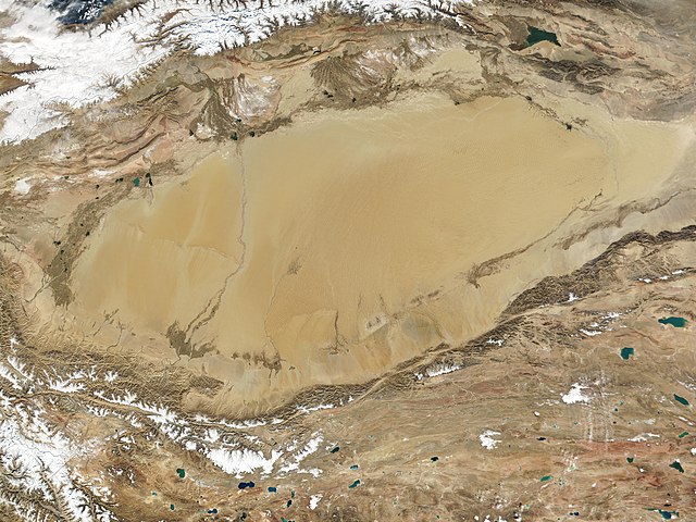
English: The Taklamakan Desert in northwest China is a vast region of sand desert sitting in a depression between two high, rugged mountain ranges. Seen in this true-color MODIS image from October 27, 2001, the Taklimakan's rolling sand dunes stretch out over several hundred thousand square miles in the Xinjiang region of China. The desert is hemmed in to the north by the snow-covered Tien Shan Mountain range and to the south by the rugged Kunlun Mountains. At the lower left corner of the image is the Karakoram Mountain range, where the world's second highest mountain, K2, casts a blue shadow (see high-resolution image for an up-close look). Desertification and shifting sand dunes are a major concern for the farmers and herders who live at the Taklimakan's edge. At the bottom of the image lies the Tibetan Plateau. |
| 日期 | 攝於2001年10月27日 |
| 來源 | http://www.gsfc.nasa.gov/indepth/photos_earth2001_p1.html (archive) |
| 作者 | NASA/GSFC/MODIS Team |
授權條款
| 本作品由NASA創作,屬於公有領域。根據NASA的版權政策:“NASA的創作除非另有聲明否則不受版權保護。”(參見:Template:PD-USGov/zh,NASA版權政策或JPL圖像使用政策) | ||
 |
警告:
|
檔案歷史
點選日期/時間以檢視該時間的檔案版本。
| 日期/時間 | 縮圖 | 尺寸 | 使用者 | 備註 | |
|---|---|---|---|---|---|
| 目前 | 2020年9月27日 (日) 02:05 | | 4,800 × 3,600(2.79 MB) | Huntster | 250m resolution version. |
| 2005年8月23日 (二) 21:33 |  | 1,200 × 900(324 KB) | Nanosmile | Description: The Taklimakan Desert in northwest China is a vast region of sand desert sitting in a depression between two high, rugged mountain ranges. Seen in this true-color MODIS image from October 27, 2001, the Taklimakan's rolling sand dunes stretch |
檔案用途
下列頁面有用到此檔案:
全域檔案使用狀況
以下其他 wiki 使用了這個檔案:
- af.wikipedia.org 的使用狀況
- als.wikipedia.org 的使用狀況
- bn.wikipedia.org 的使用狀況
- br.wikipedia.org 的使用狀況
- ca.wikipedia.org 的使用狀況
- de.wikipedia.org 的使用狀況
- en.wikipedia.org 的使用狀況
- eo.wikipedia.org 的使用狀況
- es.wikipedia.org 的使用狀況
- et.wikipedia.org 的使用狀況
- eu.wikipedia.org 的使用狀況
- fa.wikipedia.org 的使用狀況
- fi.wikipedia.org 的使用狀況
- fr.wikipedia.org 的使用狀況
- gl.wikipedia.org 的使用狀況
- he.wikipedia.org 的使用狀況
- hu.wikipedia.org 的使用狀況
- hy.wikipedia.org 的使用狀況
- id.wikipedia.org 的使用狀況
- it.wikipedia.org 的使用狀況
- ku.wikipedia.org 的使用狀況
- ky.wikipedia.org 的使用狀況
- nds.wikipedia.org 的使用狀況
- nn.wikipedia.org 的使用狀況
- no.wikipedia.org 的使用狀況
- pt.wikipedia.org 的使用狀況
- ro.wikipedia.org 的使用狀況
- ru.wikipedia.org 的使用狀況
- sr.wikipedia.org 的使用狀況
- th.wikipedia.org 的使用狀況
檢視此檔案的更多全域使用狀況。