
File:Typhoon maemi 2003.jpg
預覽大小:461 × 599 像素。 其他解析度:184 × 240 像素 | 369 × 480 像素 | 591 × 768 像素 | 788 × 1,024 像素 | 1,575 × 2,048 像素 | 6,000 × 7,800 像素。
原始檔案 (6,000 × 7,800 像素,檔案大小:5.89 MB,MIME 類型:image/jpeg)
摘要
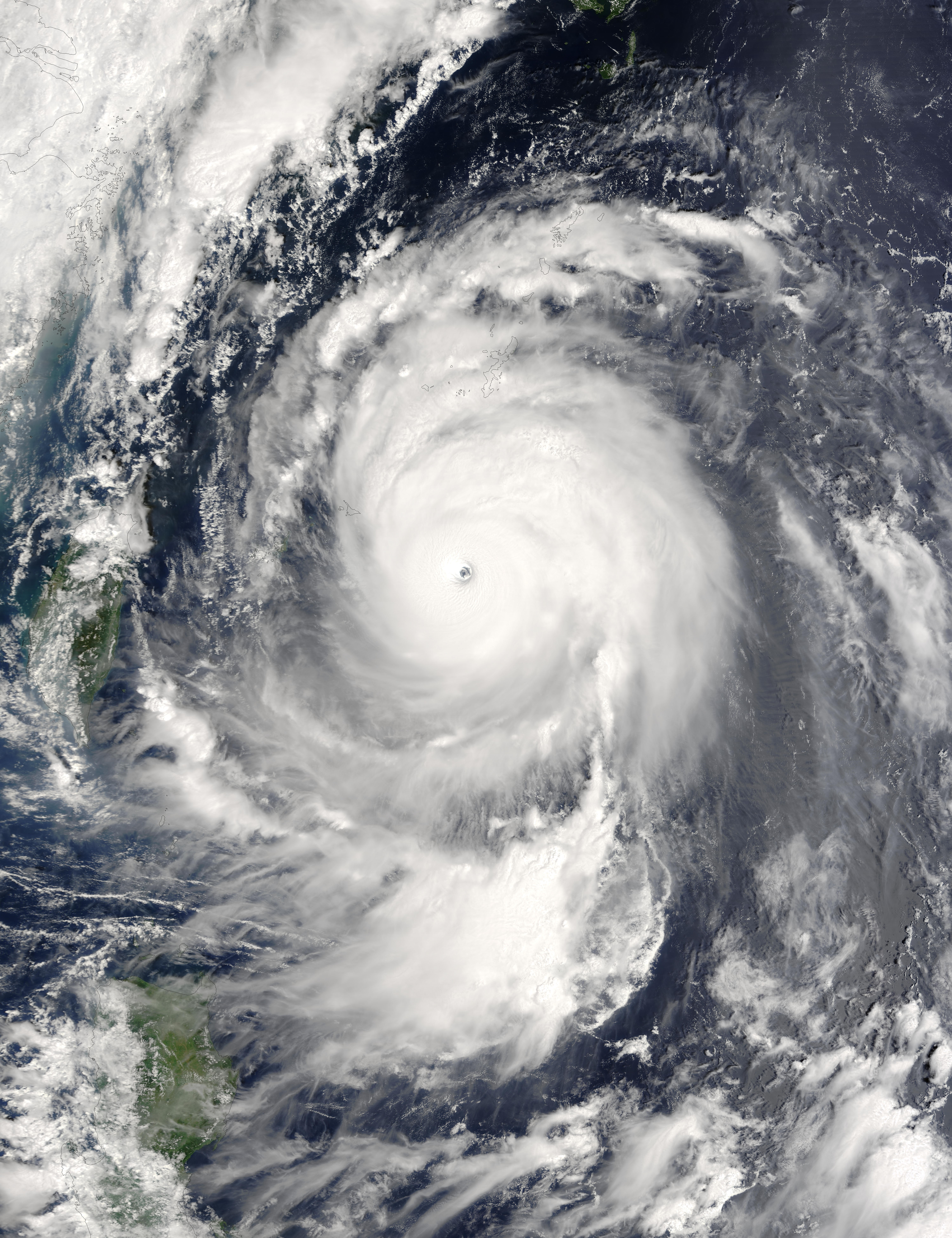
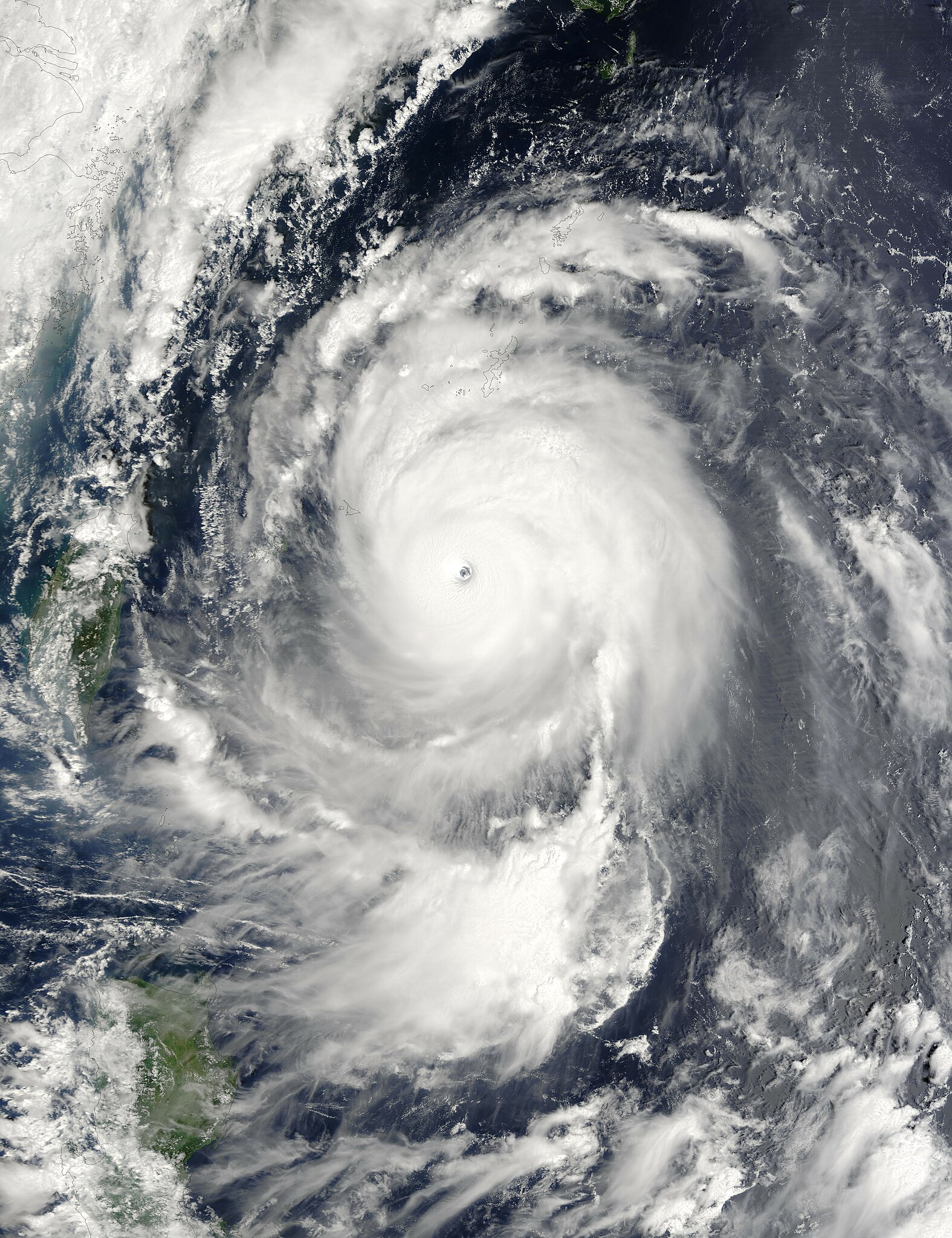
| 描述 | The MODIS instrument onboard NASA’s Terra satellite captured this true-color image of Typhoon Maemi located south-southeast of Okinawa, Japan on September 10, 2003. At the time this image was taken, Maemi was packing sustained winds of 172 mph with gusts to 200 mph. By this time, Maemi had grown into a super-typhoon, a category that the U.S. Joint Typhoon Warning Center reserves for storms with sustained wind speeds greater than 150 miles per hour. Super Typhoon Maemi would be roughly equivalent to a category 5 hurricane on the Saffir-Simpson Hurricane Scale. Maemi is the Korean name for a cicada that legend says chirps madly to warn of a coming typhoon. | |||||
| 日期 | ||||||
| 來源 | http://visibleearth.nasa.gov/view_rec.php?id=5771 | |||||
| 作者 | Jacques Descloitres, MODIS Land Rapid Response Team at NASA GSFC. | |||||
| 授權許可 (重用此檔案) |
|

檔案歷史
點選日期/時間以檢視該時間的檔案版本。
| 日期/時間 | 縮圖 | 尺寸 | 使用者 | 備註 | |
|---|---|---|---|---|---|
| 目前 | 2006年9月4日 (一) 06:35 | | 6,000 × 7,800(5.89 MB) | Good kitty | a bigger one |
| 2006年8月6日 (日) 10:30 |  | 3,000 × 3,900(1.92 MB) | Irfanfaiz | Larger version. | |
| 2006年8月4日 (五) 07:24 |  | 1,500 × 1,950(626 KB) | Irfanfaiz | {{Information |Description=The {{w|MODIS}} instrument onboard {{w|NASA}}'s Terra satellite captured this true-color image of {{w|Typhoon Maemi}} located approximately 400 miles south-southest of {{w|Okinawa}}, {{w|Japan}}. At the time this image was taken |
檔案用途
下列15個頁面有用到此檔案:
- 2003年太平洋颱風季
- 颱風梅米
- Talk:除名太平洋颱風名稱列表
- Talk:颱風梅米
- Wikipedia:优良条目/2016年4月
- Wikipedia:优良条目/2016年4月5日
- Wikipedia:优良条目/台风梅米
- Wikipedia:典范条目/2016年4月
- Wikipedia:典范条目/2016年4月8日
- Wikipedia:典范条目/2018年7月
- Wikipedia:典范条目/2018年7月4日
- Wikipedia:典范条目/2022年2月
- Wikipedia:典范条目/2022年2月14日
- Wikipedia:典范条目/颱風梅米
- WikiProject:太平洋颱風季/條目/典範條目
全域檔案使用狀況
以下其他 wiki 使用了這個檔案:
- cy.wikipedia.org 的使用狀況
- en.wikipedia.org 的使用狀況
- 2003 Pacific typhoon season
- Typhoon Maemi
- Portal:Tropical cyclones/Anniversaries/September
- Portal:Tropical cyclones/Anniversaries/September/10
- Wikipedia:WikiProject Tropical cyclones/Featured topics
- Wikipedia:Today's featured article/March 2021
- User:Gog the Mild/Blurbs/Archive 1
- Tropical cyclones in 2003
- Wikipedia:Today's featured article/March 11, 2021
- Wikipedia:Main Page history/2021 March 11
- Wikipedia:Main Page history/2021 March 11b
- es.wikipedia.org 的使用狀況
- fa.wikipedia.org 的使用狀況
- fr.wikipedia.org 的使用狀況
- ko.wikipedia.org 的使用狀況
- 태풍 매미
- 토론:9·11 테러
- 태풍
- 토론:대한항공 858편 폭파 사건
- 토론:홀로코스트
- 토론:진주만 공격
- 토론:허리케인 카트리나
- 토론:대연각호텔 화재
- 위키백과:유저박스/유저박스 모음/기타흥미
- 토론:스리마일섬 원자력 발전소
- 토론:버지니아 공대 총기 난사 사건
- 토론:간토 대학살
- 위키프로젝트:재난
- 토론:제2연평해전
- 토론:강릉지역 무장공비 침투사건
- 토론:대구 지하철 화재 참사
- 토론:I-35W 미시시피강 다리
- 토론:테러리즘
- 토론:지진
- 토론:지진 목록
- 분류토론:연도별 지진
- 분류토론:나라별 지진
- 분류토론:지진
- 토론:1906년 샌프란시스코 지진
- 토론:니가타현 주에쓰 해역 지진
- 토론:2007년 페루 지진
- 분류토론:대한민국의 지진
- 분류토론:미국의 지진
- 분류토론:인도네시아의 지진
- 분류토론:일본의 지진
- 토론:간토 대지진
- 토론:효고현 남부 지진
- 분류토론:칠레의 지진
- 분류토론:파키스탄의 지진
- 토론:2005년 카슈미르 지진
檢視此檔案的更多全域使用狀況。