
File:UNsierraleone.PNG

原始檔案 (2,293 × 2,895 像素,檔案大小:1.71 MB,MIME 類型:image/png)
摘要
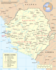
Map of Sierra Leone.
Source: http://www.un.org/Depts/Cartographic/map/profile/sierrale.pdf
| This image is a map derived from a United Nations map.
Unless stated otherwise, UN maps are to be considered in the public domain. This applies worldwide. UN maps are, in principle, open source material and you can use them in your work or for making your own map. UN requests however that you delete the UN name, logo and reference number upon any modification to the map. Content of your map will be your responsibility. You can state in your publication, if you wish, something like: based on UN map … (map name, map number, revision number and date). See: Geospatial Information Section. And: Geospatial, location data for a better world. |
 |
檔案歷史
點選日期/時間以檢視該時間的檔案版本。
| 日期/時間 | 縮圖 | 尺寸 | 使用者 | 備註 | |
|---|---|---|---|---|---|
| 目前 | 2023年7月8日 (六) 14:04 | | 2,293 × 2,895(1.71 MB) | Lojwe | Cropped 2 % horizontally, 2 % vertically using CropTool with precise mode. |
| 2007年10月23日 (二) 02:11 |  | 2,349 × 2,947(1.7 MB) | Jeroen | Much higher resolution. | |
| 2006年1月9日 (一) 00:57 |  | 615 × 773(176 KB) | Taichi | Map of Sierra Leone. Source: http://www.un.org/Depts/Cartographic/map/profile/sierrale.pdf {{PD-UN}} Category:Sierra Leone |
檔案用途
下列3個頁面有用到此檔案:
全域檔案使用狀況
以下其他 wiki 使用了這個檔案:
- ar.wikipedia.org 的使用狀況
- avk.wikipedia.org 的使用狀況
- azb.wikipedia.org 的使用狀況
- az.wikipedia.org 的使用狀況
- bg.wikipedia.org 的使用狀況
- bn.wikipedia.org 的使用狀況
- ca.wikipedia.org 的使用狀況
- Sierra Leone
- Guerra Civil de Sierra Leone
- Resolució 1132 del Consell de Seguretat de les Nacions Unides
- Resolució 1270 del Consell de Seguretat de les Nacions Unides
- Resolució 1299 del Consell de Seguretat de les Nacions Unides
- Resolució 1400 del Consell de Seguretat de les Nacions Unides
- Resolució 1492 del Consell de Seguretat de les Nacions Unides
- Resolució 1508 del Consell de Seguretat de les Nacions Unides
- Resolució 1537 del Consell de Seguretat de les Nacions Unides
- Resolució 1610 del Consell de Seguretat de les Nacions Unides
- Missió de les Nacions Unides a Sierra Leone
- Resolució 1620 del Consell de Seguretat de les Nacions Unides
- Oficina Integral de les Nacions Unides a Sierra Leone
- Resolució 1829 del Consell de Seguretat de les Nacions Unides
- Oficina de les Nacions Unides per a la Consolidació de la Pau a Sierra Leone
- Resolució 1940 del Consell de Seguretat de les Nacions Unides
- ckb.wikipedia.org 的使用狀況
- el.wikipedia.org 的使用狀況
- en.wikipedia.org 的使用狀況
- Sierra Leone
- List of cities in Sierra Leone
- Operation Barras
- Outline of Sierra Leone
- Portal:Sierra Leone
- Portal:Sierra Leone/Selected picture
- United Nations Security Council Resolution 1132
- United Nations Security Council Resolution 1270
- United Nations Security Council Resolution 1688
- Mano, Sierra Leone
- Portal:Sierra Leone/Selected picture/6
- User:MarioGom/sandbox/Missing P21 German
- User:Northamerica1000/Topics
- es.wikipedia.org 的使用狀況
- fa.wikipedia.org 的使用狀況
- fi.wikipedia.org 的使用狀況
檢視此檔案的更多全域使用狀況。