
File:Utm-zones.jpg

原始檔案 (2,048 × 1,024 像素,檔案大小:821 KB,MIME 類型:image/jpeg)
摘要
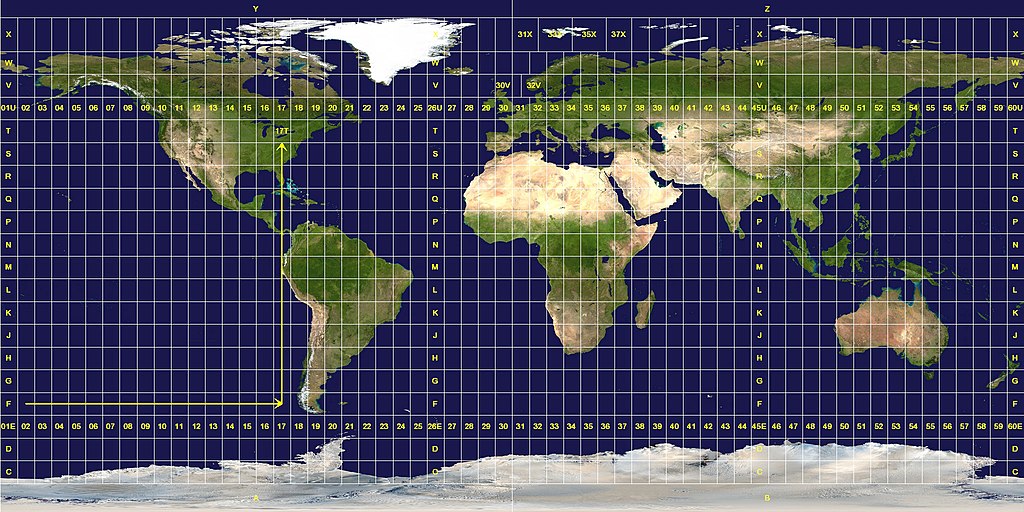
Longitude zones are six degrees wide. They are numbered from 01 at 180° west, increasing towards the east until 60 at 180° east.
Latitude zones are 8° high. They are lettered from C to X, omitting the letters "I" and "O", beginning at 80° south. The letters A, B, Y and Z are used in the polar regions by the Universal Polar Stereographic grid system.
A grid reference is read "right, up", as indicated by the arrows. A reference is always written with the longitude zone first. In this example, "17T".
Exceptions to the system are apparent. The west coast of Norway is given a wider zone 32V, taking some space from the zone 31V that covers open water. The zones around Svalbard are also widened, effectively deleting some longitude zones at this latitude. Finally, the entire latitude zone "X" is extended an extra 4°, topping off at 84° north.授權條款
此作品在美國屬於公有領域,因為其是由美國政府的官員或僱員,基於其個人公務目的製作的作品,參考美國法典第17篇第1章第105條。
注意︰本模板僅適用於美國聯邦政府的原創作品,不適用於任何美國州、屬地、聯邦個體、縣、市或任何次級政府的作品。本模板也不適用於1978年以後由美國郵政署出版的郵票圖案(參看美國版權局實踐綱領第313.6(C)(1)條)。也不適用於部分美國硬幣;參看美國鑄幣局使用條款。 |
 | |
| 此作品無已知的著作權限制,亦不受所有相關和鄰接的權利限制。 | ||
This image was constructed from a public domain Visible Earth product of the Earth Observatory office of the United States government space agency NASA. It is based on a cylindrical equi-distant projection, and was marked up by custom software created specifically for the Wikipedia.
| 此檔案採用創用CC 姓名標示-相同方式分享 3.0 未在地化版本授權條款。 受免責聲明的約束。 | ||
| ||
| 已新增授權條款標題至此檔案,作為GFDL授權更新的一部份。 |

|
已授權您依據自由軟體基金會發行的無固定段落、封面文字和封底文字GNU自由文件授權條款1.2版或任意後續版本,對本檔進行複製、傳播和/或修改。該協議的副本列在GNU自由文件授權條款中。 受免責聲明的約束。 |
檔案歷史
點選日期/時間以檢視該時間的檔案版本。
| 日期/時間 | 縮圖 | 尺寸 | 使用者 | 備註 | |
|---|---|---|---|---|---|
| 目前 | 2007年1月26日 (五) 11:08 | | 2,048 × 1,024(821 KB) | Jan Krymmel~commonswiki | The longitude and latitude zones in the Universal Transverse Mercator system. Longitude zones are six degrees wide. They are numbered from 01 at 180° west, increasing towards the east until 60 at 180° east. Latitude zones are 8° high. They are le |
檔案用途
下列頁面有用到此檔案:
全域檔案使用狀況
以下其他 wiki 使用了這個檔案:
- ar.wikipedia.org 的使用狀況
- ast.wikipedia.org 的使用狀況
- ca.wikipedia.org 的使用狀況
- cs.wikipedia.org 的使用狀況
- da.wikipedia.org 的使用狀況
- de.wikipedia.org 的使用狀況
- en.wikipedia.org 的使用狀況
- es.wikipedia.org 的使用狀況
- et.wikipedia.org 的使用狀況
- eu.wikipedia.org 的使用狀況
- fa.wikipedia.org 的使用狀況
- he.wikipedia.org 的使用狀況
- hu.wikipedia.org 的使用狀況
- ilo.wikipedia.org 的使用狀況
- ko.wikipedia.org 的使用狀況
- mk.wikipedia.org 的使用狀況
- nl.wikipedia.org 的使用狀況
- no.wikipedia.org 的使用狀況
- pl.wikipedia.org 的使用狀況
- pt.wikipedia.org 的使用狀況
- sv.wikipedia.org 的使用狀況
- ta.wikipedia.org 的使用狀況
- th.wikipedia.org 的使用狀況
- uk.wikipedia.org 的使用狀況