
File:Wembley Twin Towers - geograph.org.uk - 258671.jpg
預覽大小:398 × 600 像素。 其他解析度:159 × 240 像素 | 420 × 633 像素。
原始檔案 (420 × 633 像素,檔案大小:229 KB,MIME 類型:image/jpeg)
摘要
| 描述 |
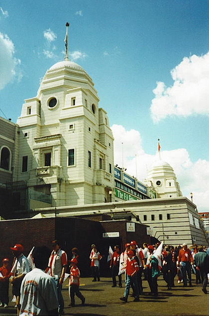
English: Wembley Twin Towers These concrete towers were claimed to be crumbling and beyond repair when Wembley Stadium was demolished. Here a mix of supporters in red are gathering for the FA Trophy Final between Kidderminster Harriers and Woking. |
| 日期 | |
| 來源 | From geograph.org.uk |
| 作者 | Colin Smith |
| 姓名標示 (由许可协议要求) | Colin Smith / Wembley Twin Towers / |
| 拍攝地點 | | 位於此地的本圖片與其他圖片: OpenStreetMap |
|---|
_heading:135.00&language=zh-hant)
| 目標地點 | | 位於此地的本圖片與其他圖片: OpenStreetMap |
|---|
_heading:135.00&language=zh-hant)
授權條款

|
此檔案採用創用CC 姓名標示-相同方式分享 2.0 通用版授權條款。
姓名標示: Colin Smith
- 您可以自由:
- 分享 – 複製、發佈和傳播本作品
- 重新修改 – 創作演繹作品
- 惟需遵照下列條件:
- 姓名標示 – 您必須指名出正確的製作者,和提供授權條款的連結,以及表示是否有對內容上做出變更。您可以用任何合理的方式來行動,但不得以任何方式表明授權條款是對您許可或是由您所使用。
- 相同方式分享 – 如果您利用本素材進行再混合、轉換或創作,您必須基於如同原先的相同或兼容的條款,來分布您的貢獻成品。
檔案歷史
點選日期/時間以檢視該時間的檔案版本。
| 日期/時間 | 縮圖 | 尺寸 | 使用者 | 備註 | |
|---|---|---|---|---|---|
| 目前 | 2013年8月23日 (五) 09:15 | | 420 × 633(229 KB) | Hic et nunc | cropped to remove white border, a bit less yellow |
| 2010年8月25日 (三) 18:00 |  | 426 × 640(102 KB) | GeographBot | == {{int:filedesc}} == {{Information |description={{en|1=Wembley Twin Towers These concrete towers were crumbling and were beyond repair when Wembley Stadium was demolished. Here a mix of supporters in red are gathering for the FA Trophy Final between Ki |
檔案用途
下列頁面有用到此檔案:
全域檔案使用狀況
以下其他 wiki 使用了這個檔案:
- cs.wikipedia.org 的使用狀況
- en.wikipedia.org 的使用狀況
- fa.wikipedia.org 的使用狀況
- fr.wikipedia.org 的使用狀況
- ko.wikipedia.org 的使用狀況
- pl.wikipedia.org 的使用狀況
- pt.wikipedia.org 的使用狀況
- ro.wikipedia.org 的使用狀況
- ru.wikipedia.org 的使用狀況
- uk.wikipedia.org 的使用狀況
- vi.wikipedia.org 的使用狀況