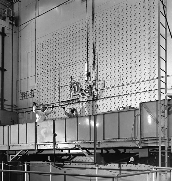
File:X10 Reactor Face.jpg
外觀

預覽大小:569 × 599 像素。 其他解析度:228 × 240 像素 | 456 × 480 像素 | 729 × 768 像素 | 972 × 1,024 像素 | 2,400 × 2,528 像素。
原始檔案 (2,400 × 2,528 像素,檔案大小:2.67 MB,MIME 類型:image/jpeg)
檔案歷史
點選日期/時間以檢視該時間的檔案版本。
| 日期/時間 | 縮圖 | 尺寸 | 使用者 | 備註 | |
|---|---|---|---|---|---|
| 目前 | 2009年6月12日 (五) 18:44 |  | 2,400 × 2,528(2.67 MB) | SeeingI~commonswiki | Changed from CMYK to Grayscale for web viewing. |
| 2009年6月12日 (五) 18:43 |  | 2,400 × 2,528(5.27 MB) | SeeingI~commonswiki | {{Information |Description={{en|1=Workers load uranium slugs into the X10 Graphite Reactor face in Oak Ridge, TN. Built as part of the Manhattan Project, X10 was the first-ever production reactor, and is now a National Historic Landmark. It |
檔案用途
全域檔案使用狀況
以下其他 wiki 使用了這個檔案:
- af.wikipedia.org 的使用狀況
- ar.wikipedia.org 的使用狀況
- cs.wikipedia.org 的使用狀況
- da.wikipedia.org 的使用狀況
- de.wikipedia.org 的使用狀況
- en.wikipedia.org 的使用狀況
- Manhattan Project
- Oak Ridge National Laboratory
- X-10 Graphite Reactor
- User:James086/portfolio
- User:Maury Markowitz/Sandbox
- Talk:X-10 Graphite Reactor
- Wikipedia:Featured pictures/Engineering and technology/Others
- Wikipedia:WikiProject Military history/Showcase
- Wikipedia:WikiProject Military history/Showcase/FP
- Ed Westcott
- Wikipedia talk:Featured and good topic questions/Archive 6
- Wikipedia:Featured pictures thumbs/32
- User talk:James086/Archives/2013
- Wikipedia:Picture peer review/X10 Graphite Reactor
- Wikipedia:Featured picture candidates/February-2013
- Wikipedia:WikiProject Military history/News/March 2013/Articles
- Wikipedia:Featured picture candidates/X-10 Reactor
- Wikipedia:Picture peer review/Archives/Oct-Dec 2012
- User talk:James086/Archives/2014
- Wikipedia:Picture of the day/June 2014
- Template:POTD/2014-06-09
- Wikipedia:Main Page history/2014 June 9
- Wikipedia:Today's featured article/June 2018
- Template:Did you know nominations/X-10 Graphite Reactor
- Wikipedia:Recent additions/2016/February
- Wikipedia:WikiProject Military history/News/December 2016/Review essay
- Wikipedia:Wikipedia Signpost/2017-06-09/Featured content
- Wikipedia:Wikipedia Signpost/Single/2017-06-09
- Wikipedia:Today's featured article/June 2, 2018
- Wikipedia:Main Page history/2018 June 2
- Portal:Nuclear technology/Articles
- Portal:Nuclear technology/Pictures
- Portal:Nuclear technology/Articles/28
- Portal:Nuclear technology/Pictures/43
- Wikipedia:Did you know/Statistics/Monthly DYK pageview leaders/2016/February
- es.wikipedia.org 的使用狀況
- fa.wikipedia.org 的使用狀況
- fr.wikipedia.org 的使用狀況
- gl.wikipedia.org 的使用狀況
檢視此檔案的更多全域使用狀況。


