
File:Zooming on the yardangs of Mount Sharp with Remote Micro Imager - sol 1994.jpg

原始檔案 (4,400 × 2,512 像素,檔案大小:3.31 MB,MIME 類型:image/jpeg)
摘要
| 描述 |
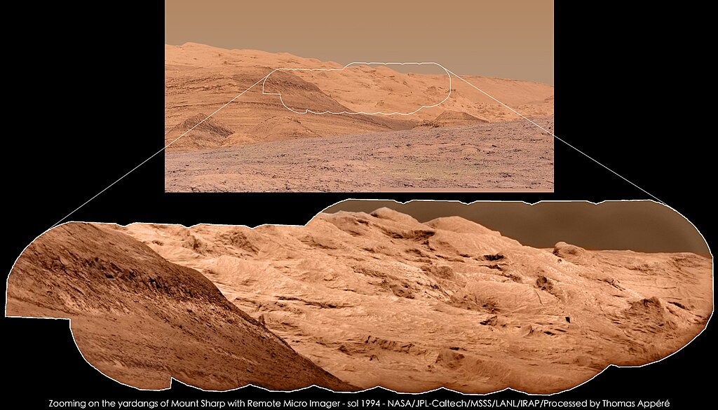
The Remote Micro Imager, part of ChemCam instrument, has imaged yardangs of Mount Sharp on sol 1994 at 12h00 local time. Yardangs are geologic structures carved by wind, observed in most Earth's deserts. Top image is a mosaic of 2 photos taken by the MastCam 100mm camera. Bottom image was obtained using the technique of pansharpening, i.e. the fusion of the RMI mosaic, providing details, and the MastCam 100mm image, providing colors. L'instrument Remote Micro Imager, qui fait partie de l'instrument ChemCam, a photographié les yardangs du Mont Sharp au sol 1994 à 12h00 heure locale.. Les yardangs sont des structures géologiques creusées par le vent, observées dans la plupart des déserts terrestres. L'image du haut est une mosaïque de 6 images acquises par la caméra MastCam 100 mm. L'image du bas a été obtenue grâce à la technique du "pansharpening", c'est-à-dire la fusion de la mosaïque RMI, qui fournit les détails, avec l'image MastCam 100 mm, qui apporte les couleurs. |
| 日期 | |
| 來源 | Zooming on the yardangs of Mount Sharp with Remote Micro Imager - sol 1994 |
| 作者 | Thomas Appéré from Saint-Avé, France |
授權條款
- 您可以自由:
- 分享 – 複製、發佈和傳播本作品
- 重新修改 – 創作演繹作品
- 惟需遵照下列條件:
- 姓名標示 – 您必須指名出正確的製作者,和提供授權條款的連結,以及表示是否有對內容上做出變更。您可以用任何合理的方式來行動,但不得以任何方式表明授權條款是對您許可或是由您所使用。
- 相同方式分享 – 如果您利用本素材進行再混合、轉換或創作,您必須基於如同原先的相同或兼容的條款,來分布您的貢獻成品。
| 這幅圖片原始出處為Flickr的https://flickr.com/photos/105035663@N07/40344654384 ,作者為Thomas Appéré 。經機器人FlickreviewR 2在2018年7月3日審查後確定為採用cc-by-sa-2.0的協議授權使用。 |
檔案歷史
點選日期/時間以檢視該時間的檔案版本。
| 日期/時間 | 縮圖 | 尺寸 | 使用者 | 備註 | |
|---|---|---|---|---|---|
| 目前 | 2018年7月3日 (二) 17:50 | | 4,400 × 2,512(3.31 MB) | Tillman | Transferred from Flickr via #flickr2commons |
檔案用途
下列頁面有用到此檔案:
全域檔案使用狀況
以下其他 wiki 使用了這個檔案:
- en.wikipedia.org 的使用狀況