
File:1696 Genroku 9 (early Edo) Japanese Map of Kyoto, Japan - Geographicus - Kyoto-genroku9-1696.jpg

預覽大小:437 × 599 像素。 其他解析度:175 × 240 像素 | 350 × 480 像素 | 560 × 768 像素 | 747 × 1,024 像素 | 1,494 × 2,048 像素 | 4,478 × 6,139 像素。
原始檔案 (4,478 × 6,139 像素,檔案大小:6.91 MB,MIME 類型:image/jpeg)
_Japanese_Map_of_Kyoto,_Japan_-_Geographicus_-_Kyoto-genroku9-1696.jpg?uselang=zh-hk)
_Japanese_Map_of_Kyoto,_Japan_-_Geographicus_-_Kyoto-genroku9-1696.jpg?uselang=zh-hk)
_Japanese_Map_of_Kyoto,_Japan_-_Geographicus_-_Kyoto-genroku9-1696.jpg?action=history&uselang=zh-hk)
_Japanese_Map_of_Kyoto,_Japan_-_Geographicus_-_Kyoto-genroku9-1696.jpg)
| Kyoto. | ||||||
|---|---|---|---|---|---|---|
| 作家 | ||||||
| 標題 |
Kyoto. |
|||||
| 描述 |
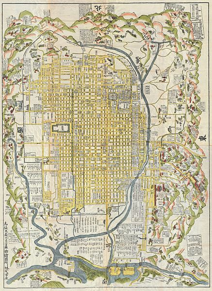
English: A rare 1696 Japanese woodblock map of Kyoto, Japan. Made in the early Edo period during the 9th year of Genroku era. Covers the city of Kyoto and its immediate vicinity. Like most early Japanese maps, this map does not have a firm directional orientation, rather all text radiates out from the center. Labels streets, waterways, mountains and important buildings. Despite 1696 date, it may be a reissue circa 1860, based upon the type of paper used. |
|||||
| 日期 | 1696年 (dated: Genroku 9, early Edo) | |||||
| 尺寸 | 高度:60英寸(152.4釐米);寬度:45英寸(114.3釐米) | |||||
| 登錄號 |
Geographicus link: Kyoto-genroku9-1696 |
|||||
| 來源/攝影者 |
|
|||||
| 授權許可 (重用此檔案) |
|
|||||
檔案歷史
點選日期/時間以檢視該時間的檔案版本。
| 日期/時間 | 縮圖 | 尺寸 | 用戶 | 備註 | |
|---|---|---|---|---|---|
| 目前 | 2011年3月22日 (二) 15:25 | | 4,478 × 6,139(6.91 MB) | BotMultichillT | {{subst:User:Multichill/Geographicus |link=http://www.geographicus.com/P/AntiqueMap/Kyoto-genroku9-1696 |product_name=1696 Genroku 9 (early Edo) Japanese Map of Kyoto, Japan |map_title=Kyoto. |description=A rare and extraordinary 1696 Japanese woodblock m |
檔案用途
下列頁面有用到此檔案:
全域檔案使用狀況
以下其他 wiki 使用了這個檔案:
- br.wikipedia.org 的使用狀況
- ckb.wikipedia.org 的使用狀況
- de.wikipedia.org 的使用狀況
- en.wikipedia.org 的使用狀況
- es.wikipedia.org 的使用狀況
- fr.wikipedia.org 的使用狀況
- gl.wikipedia.org 的使用狀況
- it.wikipedia.org 的使用狀況
- ja.wikipedia.org 的使用狀況
- ko.wikipedia.org 的使用狀況
- pt.wikipedia.org 的使用狀況
- ru.wikipedia.org 的使用狀況
- simple.wikipedia.org 的使用狀況
- sl.wikipedia.org 的使用狀況
- sr.wikipedia.org 的使用狀況
- sv.wikipedia.org 的使用狀況
- vi.wikipedia.org 的使用狀況
- www.wikidata.org 的使用狀況
_Japanese_Map_of_Kyoto,_Japan_-_Geographicus_-_Kyoto-genroku9-1696.jpg)